More From Contributor

£3.50
Higher Disley & Furness Vale in 1907 in a fascinating series of reproductions of old Ordnance Survey plans in the Alan Godfrey Editions, ideal for anyone interested in the history of their neighbourhood or family. The map is double-sided. The main map covers the area around Higher Disley, stretching from Danebank eastward to Broadhey Hill, & from New Mills station southward to Kiln Knoll. Features include Badgersclough, Albert Works, Higher Greenshall, Disley Hall, Pottershey, etc. On the reverse is the adjacent sheet 20.16, extending coverage eastward to the Cheshire boundary (the Derbyshire area is left blank on this sheet). This side covers Furness Vale, including Furness Vale station, Furness Print Works & Furness House. About the Alan Godfrey Editions of the 25” OS Series: Selected towns in Great Britain & Ireland are covered by maps showing the extent of urban development in the last decades of the 19th & early 20th century. The plans have been taken from the Ordnance Survey mapping & reprinted at about 15 inches to one mile (1:4, 340). On the reverse most maps have historical notes & many also include extracts from contemporary directories. Most maps cover about one mile (1.6kms) north/south, one & a half miles (2.4kms) across; adjoining sheets can be combined to provide wider coverage.FOR MORE INFORMATION & A COMPLETE LIST OF ALL AVAILABLE TITLES PLEASE CLICK ON THE SERIES LINK. ...
Archived Product
£8.99
Planning your next beach break or a trip around the world, but worried about the footprint you`ll leave behind? Never fear
- it
...
Archived Product
£14.99
For decades now, Martin Moran has made his living as a mountain guide based in Strathcarron, Wester Ross. The Scottish hills have by no means bound or defined him though. It was after his ascent of the North Face of the Eiger that he made his decision to take the mountain guide qualifications. Martin has climbed & guided in the Alps, Norway, & the Himalayas, experiencing life changing adventures, near death experiences, meeting & guiding many interesting people. Humour has never been far away, but neither has excitement & interest. He has lived life in the mountains to the full & this is his story. ...
Archived Product
£45.00
` Monumental!`
- Bob Ross, Australian Sailing High Performance Sailing is now regarded as the bible of racing sailors & carries
...
Archived Product
£10.99
Stephen Venables is one of the greatest British climbers of his generation & he has now written a full autobiography
- Higher than
...
Archived Product
£3.50
Highgate in 1869 in a fascinating series of reproductions of old Ordnance Survey plans in the Alan Godfrey Editions, ideal for anyone interested in the history of their neighbourhood or family. Three versions have been published for this area, stretching from Fitzroy Park eastward to Hazellville Road & from Shepherds Hill Road southward to Highgate Cemetery. Features include Park House Penitentiary, Highgate Cemetery, Waterlow Park, Shepherds Hill, a stretch of the GNR High Barnet line including Highgate station & part of Crouch End station, St Pancras Infirmary, Holborn Union Infirmary, a workhouse & Archway. Streets include North Road, North Hill, The Grove, Pond Square, Hampstead Lane, Highgate Hill, Archway Road, St John`s Road. This 1869 map has a description of Highgate Cemetery from Walford`s Old & New London. About the Alan Godfrey Editions of the 25” OS Series: Selected towns in Great Britain & Ireland are covered by maps showing the extent of urban development in the last decades of the 19th & early 20th century. The plans have been taken from the Ordnance Survey mapping & reprinted at about 15 inches to one mile (1:4, 340). On the reverse most maps have historical notes & many also include extracts from contemporary directories. Most maps cover about one mile (1.6kms) north/south, one & a half miles (2.4kms) across; adjoining sheets can be combined to provide wider coverage.FOR MORE INFORMATION & A COMPLETE LIST OF ALL AVAILABLE TITLES PLEASE CLICK ON THE SERIES LINK. ...
Archived Product
£3.50
Highgate in 1894 in a fascinating series of reproductions of old Ordnance Survey plans in the Alan Godfrey Editions, ideal for anyone interested in the history of their neighbourhood or family. Three versions have been published for this area, stretching from Fitzroy Park eastward to Hazellville Road & from Shepherds Hill Road southward to Highgate Cemetery. Features include Park House Penitentiary, Highgate Cemetery, Waterlow Park, Shepherds Hill, a stretch of the GNR High Barnet line including Highgate station & part of Crouch End station, St Pancras Infirmary, Holborn Union Infirmary, a workhouse & Archway. Streets include North Road, North Hill, The Grove, Pond Square, Hampstead Lane, Highgate Hill, Archway Road, St John`s Road. The 1894 map

Includes::
extracts from early directories. About the Alan Godfrey Editions of the 25” OS Series: Selected towns in Great Britain & Ireland are covered by maps showing the extent of urban development in the last decades of the 19th & early 20th century. The plans have been taken from the Ordnance Survey mapping & reprinted at about 15 inches to one mile (1:4, 340). On the reverse most maps have historical notes & many also include extracts from contemporary directories. Most maps cover about one mile (1.6kms) north/south, one & a half miles (2.4kms) across; adjoining sheets can be combined to provide wider coverage.FOR MORE INFORMATION & A COMPLETE LIST OF ALL AVAILABLE TITLES PLEASE CLICK ON THE SERIES LINK.

...
Archived Product
£3.50
Highgate in 1913 in a fascinating series of reproductions of old Ordnance Survey plans in the Alan Godfrey Editions, ideal for anyone interested in the history of their neighbourhood or family. Three versions have been pubslished for this area, stretching from Fitzroy Park eastward to Hazellville Road & from Shepherds Hill Road southward to Highgate Cemetery. Features include Park House Penitentiary, Highgate Cemetery, Waterlow Park, Shepherds Hill, a stretch of the GNR High Barnet line including Highgate station & part of Crouch End station, St Pancras Infirmary, Holborn Union Infirmary, a workhouse & Archway. Streets include North Road, North Hill, The Grove, Pond Square, Hampstead Lane, Highgate Hill, Archway Road, St John`s Road. The 1913 map

Includes::
extracts from early directories. About the Alan Godfrey Editions of the 25” OS Series: Selected towns in Great Britain & Ireland are covered by maps showing the extent of urban development in the last decades of the 19th & early 20th century. The plans have been taken from the Ordnance Survey mapping & reprinted at about 15 inches to one mile (1:4, 340). On the reverse most maps have historical notes & many also include extracts from contemporary directories. Most maps cover about one mile (1.6kms) north/south, one & a half miles (2.4kms) across; adjoining sheets can be combined to provide wider coverage.FOR MORE INFORMATION & A COMPLETE LIST OF ALL AVAILABLE TITLES PLEASE CLICK ON THE SERIES LINK.

...
Archived Product
£15.95
Highgate retains its village atmosphere & magnificent views across London. The author relates its history from wealthy Tudor residents through to the expansive Victorian times when Highgate was fortunate to obtain much public green space, & into modern times. It also acquired a cable tramway up its steep hill, a famous school founded in 1565 & one of the most picturesque cemeteries in the country. It has some notable old pubs & boasts one of the few surviving Literary & Scientific Institutions, Past residents include Baroness Coutts, Steel Gibbons & John Betjeman. ...
Archived Product
£15.99
Jack`s love of hillwalking began with a trip to the North-West Highlands where he & his son, Tom, began to explore the extraordinary mountains of Coigach & Inverpolly. Now this experienced hillwalker & geographer writes Highland Journal, an illustrated memoir looking back on his adventures. Joining the Jolly Boys, an anarchic group of Munro baggers, Jack was initiated into the world of hillwalking. Highland Journal records his adventures, the geology, the natural history & the idiosyncrasies of his climbing companions. With hair-raising moments such as walks in the deep snows of the Highland winter using crampons & ice axe & a mountain rescue on the Cuillin of Skye, readers witness the author`s transition from wide-eyed hillwalking novice to competent mountaineer. Illustrated with Jack`s own drawings & watercolours, Highland Journal also

Includes::
distinctive relief maps of each mountain climbed. The book will appeal to hillwalkers & Munro baggers, as well as readers interested in landscape & wildlife & lovers of adventure.

...
Archived Product

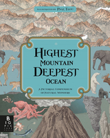
Highest Mountain, Deepest Ocean

Stanfords Children`s Book of the Month October 2016Do you know how tall the tallest mountain on Earth is? Or how deep the deepest ocean goes? Do you know which creature was the largest to ever live? Or how old the oldest tree is? Learn all this and more in this exquisite book of comparisons. Page Tsou`s extraordinarily detailed illustrations have a lithograph aesthetic that is at once vintage and contemporary.
RIP - This product is no longer available on our network. It was last seen on 25.09.2019

This page now acts as a permanent archive for this product. Add more information using the comments box below to ensure it can still be found by future generations.

Use our search facility to see if it is available from an alternative contributor.
  • External links may include paid for promotion
  • Availability: Out Of Stock
  • Supplier: Stanfords
  • SKU: 9781783704842
Availability: In Stock
£14.99

Product Description

Stanfords Children`s Book of the Month October 2016 Do you know how tall the tallest mountain on Earth is? Or how deep the deepest ocean goes? Do you know which creature was the largest to ever live? Or how old the oldest tree is? Learn all this & more in this exquisite book of comparisons. Page Tsou`s extraordinarily detailed illustrations have a lithograph aesthetic that is at once vintage & contemporary.

Reviews/Comments

Add New

Intelligent Comparison

Oooops!
We couldn't find anything!
Perhaps this product's unique.... Or perhaps we are still looking for comparisons!
Click to bump this page and we'll hurry up.

Price History

Vouchers

No voucher codes found.
Do you know a voucher code for this product or supplier? Add it to Insights for others to use.

Facebook

Jargon Buster

Contemporary - Modern era design
Contemporary - A design reference to indicate post war modern design
Earth - A planet third from the sun. Similar size to Venus but rich in water and complex life.
Month - A period of time originally related to the phases of the earths moon.
Contemporary - An object that is living in the same time.
illustrations - Pictures typically in books and newspapers.
Children - A young life form within the early stages of physical development,
Vintage - An older product that has become more quirky with time.

Supplier Information

Stanfords
Stanfords was established in 1853 and opened their iconic Covent Garden flagship store in 1901. They have become the top retailer of maps, travel books and accessories in the UK and arguably offer the largest selection of maps and travel books worldwide. Famous names such as Captain Robert Falcon Scott, Ranulph Fiennes and Michael Palin have purchased from Stanfords. They now have a shop in Bristol and both stores together with other venues operate a calendar of events including talks, book signings and exhibitions. As a specialist map retailer, the map selection is comprehensive and includes road maps, street maps and walking maps from worldwide destinations, as well as a selection of world atlases and wall maps. Books include travel guides and travel literature. Stanfords also stock globes, from miniatures made of blue marble to magnificent floor-standing globes. The website features a selection of interesting articles on travel topics.
Page Updated: 2023-11-12 20:15:36

Community Generated Product Tags

Oh No! The productWIKI community hasn't generated any tags for this product yet!
Menu