More From Contributor
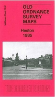
£12.50
Berlin
- Brandenburg
- Saxony-Anhalt region at 1:275, 000 in a series of eight regional road maps from Kümmerly + Frey printed

...
Archived Product
£10.99
A detailed road map with hill shading to portray the relief. Road classification is extensive & motorway junction details are drawn. Intermediate driving distances are indicated & scenic roads & special tourist sightseeing routes are highlighted. Railways & railway stations are marked & small symbols indicate campsites, youth hostels & places of interest, eg. castles, antiquities, museums churches, etc.A separate index attached to the cover gives the postcode for each locality &

Includes::
places on the map in adjacent countries beyond the German border. A grid in steps of 10` indicates latitude & longitude. Map legend

Includes::
English.


...
Archived Product
£15.99
Hesse Railways Cycle Tours, 340 kms of cycle routes & tours along the disused railway lines of Hesse, north-east of Frankfurt, presented by the Verlag Esterbauer in guide with maps at 1:50, 000 showing the route & its variants. Extensive information is conveyed by symbols, indicating road surface, campsites & other accommodation, repair workshops, recreational facilities, places of interest, etc. A list of various types of accommodation facilities is included.IMPORTANT
- PLEASE NOTE BEFORE ORDERING
- ALL THE TEXT IN THIS TITLE IS GERMAN ONLY. MAP LEGEND

Includes::
ENGLISH (please see our sample image) & the information provided on the maps is sufficient to use this title without any knowledge of German.ABOUT THE BIKELINE SERIES: all the titles have been meticulously researched & are highly regarded in their native Germany. Most titles, as indicated in their individual descriptions, also include a separate section listing selected accommodation, from hotels to campsites, youth hostels & rooms in private houses, all with addresses, telephone numbers & price range. Information on towns along each route

Includes::
a list of places of interest, with opening hours, etc. Several of the guides also have street plans. To see the list of other titles in the Bikeline series please click on the series link.


...
Archived Product
£9.99
German state of Hesse on an indexed road map at 1:200, 000 in the Mair Dumont’s Marco Polo series, prominently highlighting interesting locations & protected areas. A 95-page index booklet

Includes::
city centre street plans plus enlargements at 1:100, 000 showing in greater detail the environs & road access to Darmstadt, Frankfurt, Gießen, Kassel, Offenbach & Wiesbaden. Also included are plans of Frankfurt’s airport & the Messe exhibition grounds. Maps in this Mair Dumont Marco Polo series indicate topography by light relief shading & the series is particularly good for identifying geographical

Features:
mountain & hill chains, valleys, national/natural parks, etc. The maps boldly stress main roads & motorways in strong colours & selected towns in large letters, but also show minor roads & villages in considerable detail. Road information

Includes::
toll roads, traffic restrictions & seasonal closures, gradient marking for steep roads, etc. Motorway services clearly indicate types of facilities available there, & driving distances are marked on many small local roads. Scenic roads & special tourist routes are highlighted. Railway network

Includes::
narrow gauge & tourist lines, cable car lines, & chair lifts. Where appropriate, ferry connections are shown. Locations worth visiting, both town/villages & natural sites, are highlighted & graded; 15 best sites are prominently marked & cross-referenced to their descriptions in the accompanying booklet. Other tourist information

Includes::
campsites & youth hostels, landmarks, recreational facilities etc. Latitude & longitude grid is drawn at intervals of 10`. Each title comes with a booklet attached to the map cover containing street plans & maps at 1:100, 000 showing in greater detail road access to main cities. The booklet also provides an index listing towns/villages with their postcodes as well as rivers & landscape features, plus a table with distances/travelling times, & for route planning an overview of the whole area covered by the main map indicating the 15 special places of interest. Map legend & the descriptions include English. To see the list of titles in this series please click on the series link.


...
Archived Product
£3.50
Heston in 1894 in a fascinating series of reproductions of old Ordnance Survey plans in the Alan Godfrey Editions, ideal for anyone interested in the history of their neighbourhood or family. Two versions have been published for this area. The 1894 map shows Heston as a rural Middlesex village, surrounded by orchards or market gardens & open countryside to the west, with a clutch of roads or lanes (Fern Lane, Norwood Green Road, Smoky Lane, Church Lane), St Leonard`s church, some pubs, Heston Hall, Heston Farm & a few other buildings. To the south is the hamlet of Sutton. Cranford Lane meanders across the map. The 1935 map is more developed &

Includes::
Heston Airfield; scheduled services started here in 1933 with flights to the Isle of Wight & Chamberlain famously flew from here to meet Hitler. This map

Includes::
a 1933 directory of Heston. About the Alan Godfrey Editions of the 25” OS Series Selected towns in Great Britain & Ireland are covered by maps showing the extent of urban development in the last decades of the 19th & early 20th century. The plans have been taken from the Ordnance Survey mapping & reprinted at about 15 inches to one mile (1:4, 340). On the reverse most maps have historical notes & many also include extracts from contemporary directories. Most maps cover about one mile (1.6kms) north/south, one & a half miles (2.4kms) across; adjoining sheets can be combined to provide wider coverage.FOR MORE INFORMATION & A COMPLETE LIST OF ALL AVAILABLE TITLES PLEASE CLICK ON THE SERIES LINK.


...
Archived Product
£19.95
Topographic survey of Faroe Islands at 1:20, 000 prepared by the Danish national mapping agency Kort og Matrikelstyrelsen. The islands’ topography is vividly presented by contours at 5 metre intervals, enhanced by relief shading plus colouring and/or graphics for different types of terrain or vegetation (scree, boulders, etc). The maps show all the detail expected of the topographic mapping at this scale & have a 1-km UTM grid, plus margin ticks for latitude & longitude at 1’ & 2` respectively. Map legend is in Danish only. The maps are available either separately or as sets of five of more sheets, each covering the main island group: Vagar, Sandoy, Suduroy, Nordoyar, Streymoy & Eysturoy. To see the list of all the titles in this series please click on the series link. ...
Archived Product
£9.99
“ Het Groene Woud” map in 1:25, 000 belong to a series of eleven walking from Falk, which cover the most beautiful hiking areas in four regions: North Brabant in the south, the tip of North Holl&, Friesland & Groningen in the north of the country.“ Het Groene Woud” (the green forest) map covers an area of Approx. 26 x 16 km in North Brabant. The maps in this series feature a very detailed topography (landscape information is provided by colouring for woodlands, canals, hills, etc ) & specific information such as the distance in kilometres between junctions, the long distance footpaths & one-day walking tours with description. The paths of walking network are marked with a number. A wide range of symbols shows various accommodation options, bars & restaurants, & various places of interest. Map legend

Includes::
English. To see the list of other titles in this series please click on the series link.

...
Archived Product
£17.99
The 1:50 000 topographic map gives a more general picture of the ground features than a basic map. It shows settlements, houses, roads, cultivated areas, waterways, cutting areas, mires, rock exposures, & relief. One map sheet covers an area of 30 x 40 km & one centimetre corresponds to 500 metres on the ground. The 1:50, 000 topographic map is also an ideal complement to nautical charts as it provides useful information about the land areas adjacent to waterways. For example, all Finnish sea areas are covered by 1:50 000 topographic map sheets. ...
Archived Product
£3.50
HHetton Downs & Rainton Bridge in 1895 in a fascinating series of reproductions of old Ordnance Survey plans in the Alan Godfrey Editions, ideal for anyone interested in the history of their neighbourhood or family. The map covers an area just south of Houghton-le-Spring, with part of the village of Hetton Downs is in the south-eastern corner. Features include All Saints church, High Downs Square; Hetton Colliery Railway, Rainton & Seaham Railway; three powered inclines
- Byer Bank, Copt Hill Bank, Rainton Bank; Rainton Mill, Rainton Troughs, St Michaels RC church, Houghton cemetery, Houghton Brewery, etc. Directories for Eppleton (or Hetton Downs) & Rainton East parishes are on the reverse. About the Alan Godfrey Editions of the 25” OS Series: Selected towns in Great Britain & Ireland are covered by maps showing the extent of urban development in the last decades of the 19th & early 20th century. The plans have been taken from the Ordnance Survey mapping & reprinted at about 15 inches to one mile (1:4, 340). On the reverse most maps have historical notes & many also include extracts from contemporary directories. Most maps cover about one mile (1.6kms) north/south, one & a half miles (2.4kms) across; adjoining sheets can be combined to provide wider coverage.FOR MORE INFORMATION & A COMPLETE LIST OF ALL AVAILABLE TITLES PLEASE CLICK ON THE SERIES LINK.
...
Archived Product
£3.50
Hetton-le-Hole & East Rainton in 1895 in a fascinating series of reproductions of old Ordnance Survey plans in the Alan Godfrey Editions, ideal for anyone interested in the history of their neighbourhood or family. The map covers the village of Hetton-le-Hole, including The Square, Hetton Brewery, Hetton Hall, St Nicholas church, Bog Row, a stretch of the Hetton Colliery Railway, a stretch of the NER Durham Elvet & Murton Branch with station, Coalbank Terrace, Front Street, Four Lane Ends, etc. Coverage extends westward to East Rainton, including St Cuthberts church, Hazard Pit, a stretch of the Rainton & Seaham Railway & Dun Well Pit. Directories for both villages in 1894 are on the reverse. About the Alan Godfrey Editions of the 25” OS Series: Selected towns in Great Britain & Ireland are covered by maps showing the extent of urban development in the last decades of the 19th & early 20th century. The plans have been taken from the Ordnance Survey mapping & reprinted at about 15 inches to one mile (1:4, 340). On the reverse most maps have historical notes & many also include extracts from contemporary directories. Most maps cover about one mile (1.6kms) north/south, one & a half miles (2.4kms) across; adjoining sheets can be combined to provide wider coverage.FOR MORE INFORMATION & A COMPLETE LIST OF ALL AVAILABLE TITLES PLEASE CLICK ON THE SERIES LINK. ...
Archived Product

Heston 1935

Heston in 1935 in a fascinating series of reproductions of old Ordnance Survey plans in the Alan Godfrey Editions, ideal for anyone interested in the history of their neighbourhood or family. Two versions have been published for this area. The 1894 map shows Heston as a rural Middlesex village, surrounded by orchards or market gardens and open countryside to the west, with a clutch of roads or lanes (Fern Lane, Norwood Green Road, Smoky Lane, Church Lane), St Leonard`s church, some pubs, Heston Hall, Heston Farm and a few other buildings. To the south is the hamlet of Sutton. Cranford Lane meanders across the map. The 1935 map is more developed and includes Heston Airfield; scheduled services started here in 1933 with flights to the Isle of Wight and Chamberlain famously flew
from here to meet Hitler. This map includes a 1933 directory of Heston.About the Alan Godfrey Editions of the 25” OS SeriesSelected towns in Great Britain and Ireland are covered by maps showing the extent of urban development in the last decades of the 19th and early 20th century. The plans have been taken from the Ordnance Survey mapping and reprinted at about 15 inches to one mile (1:4, 340). On the reverse most maps have historical notes and many also include extracts from contemporary directories. Most maps cover about one mile (1.6kms) north/south, one and a half miles (2.4kms) across; adjoining sheets can be combined to provide wider coverage.FOR MORE INFORMATION AND A COMPLETE LIST OF ALL AVAILABLE TITLES PLEASE CLICK ON THE SERIES LINK.
RIP - This product is no longer available on our network. It was last seen on 25.09.2019

This page now acts as a permanent archive for this product. Add more information using the comments box below to ensure it can still be found by future generations.

Use our search facility to see if it is available from an alternative contributor.
  • Availability: Out Of Stock
  • Supplier: Stanfords
  • SKU: 9781847846518
Availability: In Stock
£3.50

Product Description

Heston in 1935 in a fascinating series of reproductions of old Ordnance Survey plans in the Alan Godfrey Editions, ideal for anyone interested in the history of their neighbourhood or family. Two versions have been published for this area. The 1894 map shows Heston as a rural Middlesex village, surrounded by orchards or market gardens & open countryside to the west, with a clutch of roads or lanes (Fern Lane, Norwood Green Road, Smoky Lane, Church Lane), St Leonard`s church, some pubs, Heston Hall, Heston Farm & a few other buildings. To the south is the hamlet of Sutton. Cranford Lane meanders across the map. The 1935 map is more developed &

Includes::
Heston Airfield; scheduled services started here in 1933 with flights to the Isle of Wight & Chamberlain famously flew from here to meet Hitler. This map

Includes::
a 1933 directory of Heston. About the Alan Godfrey Editions of the 25” OS Series Selected towns in Great Britain & Ireland are covered by maps showing the extent of urban development in the last decades of the 19th & early 20th century. The plans have been taken from the Ordnance Survey mapping & reprinted at about 15 inches to one mile (1:4, 340). On the reverse most maps have historical notes & many also include extracts from contemporary directories. Most maps cover about one mile (1.6kms) north/south, one & a half miles (2.4kms) across; adjoining sheets can be combined to provide wider coverage.FOR MORE INFORMATION & A COMPLETE LIST OF ALL AVAILABLE TITLES PLEASE CLICK ON THE SERIES LINK.

Reviews/Comments

Add New

Intelligent Comparison

Oooops!
We couldn't find anything!
Perhaps this product's unique.... Or perhaps we are still looking for comparisons!
Click to bump this page and we'll hurry up.

Price History

Vouchers

No voucher codes found.
Do you know a voucher code for this product or supplier? Add it to Insights for others to use.

Facebook

Jargon Buster

Contemporary - Modern era design
Contemporary - A design reference to indicate post war modern design
History - Anything that happens in the past. An acedemic subject.
Road - a manmade lane or a path that is used to speed up travel.
Smoky - A tone of grey, can also relate to a haze.
Contemporary - An object that is living in the same time.
Hall - A room at the inside of an entrance of a house.
Ideal - Something that satisfies a perfect criteria.
Family - A group of people that live together made up from parents and children.

Supplier Information

Stanfords
Stanfords was established in 1853 and opened their iconic Covent Garden flagship store in 1901. They have become the top retailer of maps, travel books and accessories in the UK and arguably offer the largest selection of maps and travel books worldwide. Famous names such as Captain Robert Falcon Scott, Ranulph Fiennes and Michael Palin have purchased from Stanfords. They now have a shop in Bristol and both stores together with other venues operate a calendar of events including talks, book signings and exhibitions. As a specialist map retailer, the map selection is comprehensive and includes road maps, street maps and walking maps from worldwide destinations, as well as a selection of world atlases and wall maps. Books include travel guides and travel literature. Stanfords also stock globes, from miniatures made of blue marble to magnificent floor-standing globes. The website features a selection of interesting articles on travel topics.
Page Updated: 2023-11-12 20:15:36

Community Generated Product Tags

Oh No! The productWIKI community hasn't generated any tags for this product yet!
Menu