
 United Kingdom
 France
 Germany
 Netherlands
 Sweden
 USA
USA
 Italy
Italy
 Spain
Spain
More From Contributor


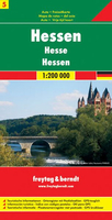
Hesse F&B
A detailed road map with hill shading to portray the relief. Road classification is extensive and motorway junction details are drawn. Intermediate driving distances are indicated and scenic roads and special tourist sightseeing routes are highlighted. Railways and railway stations are marked and small symbols indicate campsites, youth hostels and places of interest, eg. castles, antiquities, museums churches, etc.A separate index attached to the cover gives the postcode for each locality and includes places on the map in adjacent countries beyond the German border. A grid in steps of 10` indicates latitude and longitude. Map legend includes English.

Product Description
Reviews/Comments
Add New
Intelligent Comparison
Archived Product

Lesbos F&B Stanfords
£10.99
Vouchers
No voucher codes found.
Do you know a voucher code for this product or supplier? Add it to Insights for others to use.
Do you know a voucher code for this product or supplier? Add it to Insights for others to use.
 Denmark