
 United Kingdom
 France
 Germany
 Netherlands
 Sweden
 USA
USA
 Italy
Italy
 Spain
Spain
More From Contributor


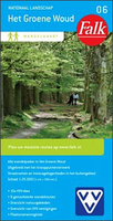
Het Groene Woud
“Het Groene Woud” map in 1:25, 000 belong to a series of eleven walking from Falk, which cover the most beautiful hiking areas in four regions: North Brabant in the south, the tip of North Holland, Friesland and Groningen in the north of the country.“Het Groene Woud” (the green forest) map covers an area of approximately 26 x 16 km in North Brabant.The maps in this series feature a very detailed topography (landscape information is provided by colouring for woodlands, canals, hills, etc ) and specific information such as the distance in kilometres between junctions, the long distance footpaths and one-day walking tours with description. The paths of walking network are marked with a number. A wide range of symbols shows various accommodation options, bars and restaurants,
and various places of interest. Map legend includes English.To see the list of other titles in this series please click on the series link.
and various places of interest. Map legend includes English.To see the list of other titles in this series please click on the series link.

Product Description
Reviews/Comments
Add New
Vouchers
No voucher codes found.
Do you know a voucher code for this product or supplier? Add it to Insights for others to use.
Do you know a voucher code for this product or supplier? Add it to Insights for others to use.
 Denmark