
 United Kingdom
 France
 Germany
 Netherlands
 Sweden
 USA
USA
 Italy
Italy
 Spain
Spain
More From Contributor


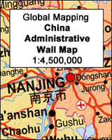
China Administrative Wall Map
China at 1:4, 500, 000 on a large administrative wall map, size 135cm x 95cm (53” x 37.5” approx), from Global Mapping showing provinces in different colours. An additional panel provides more information about each province.Names of the provinces and of the provincial capitals are shown in both Chinese and Latin alphabet; all other place names are given only transliterated. Towns are graded according to their population. The map shows the network of principal road and railway connections and indicates domestic airports. Topography is shown by subtle relief shading with names of main geographical features: mountain ranges, peaks, deserts, etc. Latitude and longitude lines are drawn at 5° intervals.Additional panel lists the administrative units indicating their status (province,
autonomous region, etc), population (in 2010) and the capital.
autonomous region, etc), population (in 2010) and the capital.

Product Description
Reviews/Comments
Add New
Vouchers
No voucher codes found.
Do you know a voucher code for this product or supplier? Add it to Insights for others to use.
Do you know a voucher code for this product or supplier? Add it to Insights for others to use.
 Denmark