
 United Kingdom
 France
 Germany
 Netherlands
 Sweden
 USA
USA
 Italy
Italy
 Spain
Spain
More From Contributor


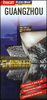

Guangzhou
Indexed street plan of Guangzhou, with an enlargement for the Shamian Island historic district, a diagram of the metro and rail network, plus a small overview map of the surrounding region showing road connections to Hong Kong and Macao.Coverage extends north to include Balyun Mountain and the The White Cloud Mountain Resort, and south across the Pearl River to Sun Yat-Sen University campus. East - west, the map extends from the various academic institutions in the Wushan district to the Datansha Island and the Zhujiang West Bridge. The map highlights traffic arteries across the city and prominently indicates public transport connections: metro stations shown with entrances/exits, local bus stands, ferry piers, coach terminals and intercity railway stations. Symbols highlight
selected tourist accommodation, places of interest, public buildings and various facilities, etc.Names of streets, neighbourhoods and districts are in Roman alphabet only. Names of some public institutions such as universities or facilties like sport centres, as well as parks, most metro stops and railways stations are also given in Chinese. The plan is indexed and also includes an enlargement for the Shamian Island Historic Urban District, a diagram of the metro and suburban rail networks and a small map showing the city
selected tourist accommodation, places of interest, public buildings and various facilities, etc.Names of streets, neighbourhoods and districts are in Roman alphabet only. Names of some public institutions such as universities or facilties like sport centres, as well as parks, most metro stops and railways stations are also given in Chinese. The plan is indexed and also includes an enlargement for the Shamian Island Historic Urban District, a diagram of the metro and suburban rail networks and a small map showing the city
Product Description
Reviews/Comments
Add New
Vouchers
No voucher codes found.
Do you know a voucher code for this product or supplier? Add it to Insights for others to use.
Do you know a voucher code for this product or supplier? Add it to Insights for others to use.
 Denmark