
 United Kingdom
 France
 Germany
 Netherlands
 Sweden
 USA
USA
 Italy
Italy
 Spain
Spain
More From Contributor


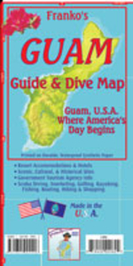
Guam Guide & Dive Map
Guam Guide and Dive Map from Franko`s Maps printed on light, waterproof and tear-resistant synthetic paper, with a wealth of information for various recreational activities, historical sights, etc, plus a map of Micronesia.On one side is a map showing the whole of Guam with enlargements on the reverse presenting Apra Harbour and Tumon Bay in greater detail. All are extensively annotated with tourist facilities and recreational sites: hiking, mountain biking, kayaking, surfing, etc, with numerous diving sites shown in the island’s coastal waters. Also marked are various historical locations, including those connected with the Guam’s history in World War II. Extensive accompanying notes provide more information, including details of the diving sites (depth in feet and metres
of numerous reefs, walls, ledges, etc) and contact details for accommodation.The map includes a street map of the centre of Agana (Hagatna) showing a 3-mile heritage trail. Also provided is an overview map of Micronesia from Palau to Kiribati, with insets showing in greater detail: Palau Islands, Yap, Tinian, Saipan, Rota, Chuuk (Truk Islands, Pohnpei Islands, Kosrae, plus the Majuro and Arno Atolls of the Marshall Islands.The map is printed on light, waterproof and tear-resistant synthetic paper and is decorated with lovely colour drawings of numerous species of fish found around Micronesia.
of numerous reefs, walls, ledges, etc) and contact details for accommodation.The map includes a street map of the centre of Agana (Hagatna) showing a 3-mile heritage trail. Also provided is an overview map of Micronesia from Palau to Kiribati, with insets showing in greater detail: Palau Islands, Yap, Tinian, Saipan, Rota, Chuuk (Truk Islands, Pohnpei Islands, Kosrae, plus the Majuro and Arno Atolls of the Marshall Islands.The map is printed on light, waterproof and tear-resistant synthetic paper and is decorated with lovely colour drawings of numerous species of fish found around Micronesia.

Product Description
Reviews/Comments
Add New
Intelligent Comparison
Archived Product
Cayman Islands Guide & Dive Map Stanfords
£9.99
Vouchers
No voucher codes found.
Do you know a voucher code for this product or supplier? Add it to Insights for others to use.
Do you know a voucher code for this product or supplier? Add it to Insights for others to use.
 Denmark