
 United Kingdom
 France
 Germany
 Netherlands
 Sweden
 USA
USA
 Italy
Italy
 Spain
Spain
More From Contributor


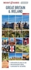


Great Britain & Ireland Michelin Wall Map ENCAPSULATED
Laminated wall map of Great Britain and Ireland at 1:1, 000, 000 from Michelin, showing roads boldly overprinted on a plain white base, with very subtle relief shading.Road detail shows motorways, A roads and B roads, all with road numbers and distances marked; ferry routes and airports are also indicated. International, national, and county and unitary authority boundaries are highlighted and named for England, with a separate legend listing district council and unitary authorities for Wales, Scotland, and Northern Ireland.The Channel and Shetland Islands are shown in separate insets.*The lamination on this wall map allows you to write on it with a felt marker and wipe it clean afterwards. It is also more durable than an ordinary paper wall map.*

Product Description
Reviews/Comments
Add New
Intelligent Comparison
Archived Product

Great Britain & Ireland Michelin Wall Map PAPER Stanfords
£14.99
Archived Product
Great Britain A-Z Wall Map ENCAPSULATED Stanfords
£24.99
Archived Product

Britain And Ireland NGS Classic Wall Map ENCAPSULATED Stanfords
£16.99
Archived Product
Paris Michelin Wall Map ENCAPSULATED Stanfords
£14.99
Archived Product
World Michelin Wall Map ENCAPSULATED Stanfords
£16.99
Archived Product
Britain And Ireland NGS Executive Wall Map ENCAPSULATED Stanfords
£17.99
Archived Product
Great Britain - Ireland Michelin Pocket Map Stanfords
£2.99
Archived Product
Great Britain A-Z REVERSIBLE Wall Map ENCAPSULATED Stanfords
£24.99
Vouchers
No voucher codes found.
Do you know a voucher code for this product or supplier? Add it to Insights for others to use.
Do you know a voucher code for this product or supplier? Add it to Insights for others to use.
 Denmark