
 United Kingdom
 France
 Germany
 Netherlands
 Sweden
 USA
USA
 Italy
Italy
 Spain
Spain
More From Contributor
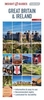


Great Britain & Ireland: Collins Handy Road Atlas 2010 - A5
SPIRAL-BOUND SUPERCEDED
This handy A5 sized road atlas makes it the ideal travelling companion. It has extremely clear, route planning maps of Britain and Ireland and fits neatly into the glovebox, pocket or bag. This clear, easy-to-use handy sized atlas has been fully updated for 2009. The maps of Britain are at 9.9 miles to 1 inch (1:625, 000) and the whole of Ireland is covered at 15.8 miles to 1 inch (1:1, 000, 000). There are also a selection of more detailed urban area maps at 4.5 miles to 1 inch (1:285, 000) to aid route planning in these busy areas. The atlas includes: / Road maps, greatly improved for 2009, that focus on the main roads, motorways and settlements. / Useful distance calculator chart highlighting distances between the major towns. / The Ireland section includes a separate distance
chart and an index. Ideal general purpose route planner in a handy lightweight format. It fits easily into the glovebox, briefcase, handbag or pocket.
chart and an index. Ideal general purpose route planner in a handy lightweight format. It fits easily into the glovebox, briefcase, handbag or pocket.
Product Description
Reviews/Comments
Add New
Vouchers
No voucher codes found.
Do you know a voucher code for this product or supplier? Add it to Insights for others to use.
Do you know a voucher code for this product or supplier? Add it to Insights for others to use.
 Denmark