More From Contributor

£5.99
Germany at 1:750, 000 from Michelin, 2012 edition, with information on driving regulations, plus a distance & journey time table. The map is an enlargement of cartography prepared to cover a wider area, so has larger that usual print & greater clarity. Roads network

Includes::
local roads & is graded according to the number of lanes. Motorways indicate toll routes & junctions show full or partial interchanges. Toll barriers, steep gradients & seasonal restrictions are marked, scenic routes are highlighted. Railway lines are not included. Relief shading is used to indicate the topography, with colouring for forested areas. Selected regional parks are also marked. Small symbols indicate various landmarks or places of interest, but the map is not designed to highlight tourist sights. The map has no geographical coordinates. Multilingual map legend

Includes::
English. The index is printed on the same side as the map. Also provided is basic information on Germany


...
Archived Product
£10.99
Germany at 1:700, 000 on a large, single-sided road map from Freytag & Berndt, with a separate extensive index booklet listing locations with postcodes & providing street plans of 18 town centres in the country’s main cities. The map shows the country’s road network, clearly distinguishing motorways & main connecting routes, shown with driving distances, from local roads. Motorway interchanges are named & services are marked. Railway lines are included. Topography is indicated by relief shading with plenty of names of geographical features such as mountain & hill ranges, woodlands, regional parks & other protected areas, etc. Small symbols indicate locations of castles & other historical buildings & monuments, but the map is not primarily designed to show tourist information. Latitude & longitude lines are drawn at 30’ intervals. Multilingual map legend

Includes::
English. Extensive index is in a separate booklet attached to the map cover & lists locations with their postcodes. The booklet also

Includes::
street plans of central Berlin, Bremen, Cologne, Dresden, Düsseldorf, Erfurt, Frankfurt, Hamburg, Hannover, Kiel, Leipzig, Magdeburg, Mainz, Munich, Potsdam, Saarbrücken, Schwerin, Stuttgart & Wiesbaden.


...
Archived Product
£5.49
Fully updated, the maps combine clear design & an easy-to-read scale with more road detail to ensure you never lose your way. Designed especially for the British motorist, all motorways are clearly shown in blue & toll motorways are highlighted. Distance markers & service stations are included, with towns of interest identified to help you plan the best route. The mapping shown on the country titles

Includes::
touring information & visitor attractions including national parks, ski resorts, beaches, top museums & churches. Roads unsuitable for caravans are also indicated, together with steep gradients. A place name index & large scale city plans, featuring street names & places of interest, complete the sheet map.

...
Archived Product
£30.00
The new ADAC Germany Maxi Atlas combines clarity & clear cartography. With the generous scale of 1:150, 000, the driver finds even the smallest roads & paths with few glances. Good legibility characterize the urban thoroughfare maps on a scale of 1:75 000. The city maps on a scale of 1:15 000 show not only the smallest streets, but also sights & nature parks. An additional service is provided by the motorway route maps. Campsites are also listed. ...
Archived Product
£40.00
The ADAC Auto Atlas shows Germany & its neighboring countries from Denmark in the north to Lake Garda in the south & from Ostende & Metz in the west to Lake Balaton & Wroclaw in the east in a clear & detailed scale. There is also a travel map section, which shows all the important car travel destinations in Europe on the ideal country map scale. Important information for traveling at home & abroad also offers you a section of information: ADAC service, travel information for all European countries, travel guide & much more. Hotel & restaurant ads are also part of this tourist section. ...
Archived Product
£13.99
An administrative wall map of Germany from Freytag & Berndt, 96 x 128cm (3ft 2” x 4ft 2” approx), showing the country at 1:700, 000 with each state in a different colour. Within the states the map shows internal divisions into regions (Regierungsbezirke) & districts (Kreise) with names of the regions. Towns also indicate their administrative status. The base map shows the country’s road & rail networks. The map comes with a separate index booklet listing all locations with their postcodes. The booklet also

Includes::
street plans of central Berlin, Bremen, Cologne, Dresden, Düsseldorf, Erfurt, Frankfurt, Hamburg, Hannover, Kiel, Leipzig, Magdeburg, Mainz, Munich, Potsdam, Saarbrücken, Schwerin, Stuttgart & Wiesbaden.

...
Archived Product
£9.99
Germany on a double-sided road map 1:825, 000 approx. from the National Geographic Society printed on light, waterproof & tear-resistant synthetic paper. Cartographic information provided by the German publishers Reise Know-How is presented here in the overall style of the NGS Adventure maps. The map divides the country north/south with a generous overlap between the sides. Names of German states are given in the original & in English (Sachsen / Saxony); geographical regions are in German only (so Schwarzwald, Bayerische Alpen, etc.) Topography is shown by colouring & shading with the names of the main geographic regions. Road network is clearly presented, although without indicating full/partial motorway interchanges or services; driving distances are shown on main routes. Railway lines are included, if not easy to see given the density of other detail, & domestic airports are marked. Symbols highlight a selection of the county’s numerous places of interest. Latitude & longitude lines are drawn at 1° intervals & the map has an index of place names. ...
Archived Product
£7.50
Long-distance hiking paths in Germany & the adjoining Alpine regions of Europeon contoured & GPS compatible, waterproof & tear-resistant maps from Kompass at 1:50, 000, presenting each trail in a series of panels accompanied by an accommodation list, street plans of local town, route profile, plus a German language guide to main places of interest. Each route is prominently highlighted on a series of 17.5 x 20cm panels & annotated with 5km markers. Topography is shown by contours (intervals at 20m or 40m) enhanced by relief shading with colouring and/or graphics for woodlands, orchards, vineyards, etc. Symbols indicate various accommodation options (hotels, campsites, youth hostels), sport facilities, & various places of interest. The maps also show locations of car parks near the route & railway lines are shown with stations. The maps have a 2km UTM grid. Each title

Includes::
street plans of local towns, a route profile, details of recommended accommodation indicating price range, plus descriptions of main places of interest. Map legend & all the text are in German only.

...
Archived Product
£20.00
Inland waterways of Germany, Belgium, Netherlands & Luxemburg on a map at 1:1, 000, 000 from the Hamburg based Edition Maritim, with enlargements for Berlin area & the Ruhr, plus the Danube from Regensburg to the Black Sea. The map shows as its base the entire river network, plus main roads & within Germany the division into states. Navigable waterways are classified into six categories according to the tonnage, length, beam, draught & headroom of the vessels. Separate markings distinguish canals from rivers, with planned extensions & new canals also marked. All the navigable waterways show existing & planned locks & ship lifts, & have kilometre markings. In the coastal regions the map also indicates the extent of inland access to sea faring ships. The map extends to include north-eastern France, west to Reims & south to the confluence of Canal de Bourgogne, the Sa ...
Archived Product
£22.50
Inland waterways of Germany, Belgium, Netherlands & Luxemburg on a map at 1:1, 000, 000 from the Hamburg based Edition Maritim, with enlargements for Berlin area & the Ruhr, plus the Danube from Regensburg to the Black Sea. The map shows as its base the entire river network, plus main roads & within Germany the division into states. Navigable waterways are classified into six categories according to the tonnage, length, beam, draught & headroom of the vessels. Separate markings distinguish canals from rivers, with planned extensions & new canals also marked. All the navigable waterways show existing & planned locks & ship lifts, & have kilometre markings. In the coastal regions the map also indicates the extent of inland access to sea faring ships. The map extends to include north-eastern France, west to Reims & south to the confluence of Canal de Bourgogne, the Saône & the Rhine-Rhône canal, plus western Czech Republic with Vltava/ Moldau & the Elbe from Kostomlátky. Latitude & longitude lines are drawn at 1º intervals. Insets present the Berlin region & the Ruhr in greater detail at 1:500, 000. The remaining part of the Danube which on the main map is covered to just beyond Linz & Mauthausen (2100kms from the Black Sea) is also shown on another inset at 1:5, 000, 000 approx. Map legend

Includes::
English, although only the main terms are translated.

...
Archived Product

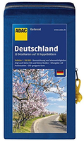
Germany ADAC Road Map Set

Germany on a set of 20 double-sided road maps at 1:200, 000 from ADFC – the equivalent of Britain’s AA. Cartography is the same as in MairDumont’s perennially popular ‘Marco Polo’ series at the same scale, but presented in a smaller format and with more prominent highlighting of interesting locations. The set is supplied in sturdy zipped pouch with also includes a separate booklet containing an index. Each map covers two numbers shown on our coverage image (1+2. 3+6, 4+5, 7+11, 8+9, 10+14, 12+13, 15+18, 16+17 and 19+20) conveniently combining adjoining regions.The maps boldly stress main roads and motorways in strong colours and main towns in large letters, but also show minor roads and villages in considerable detail. Road information includes toll roads, traffic
restrictions and seasonal closures, gradient marking for steep roads, scenic routes, border checkpoints with restrictions, etc. Motorway services clearly indicate types of facilities available there. Railway network includes narrow gauge and tourist lines, and indicates car-loading terminal. Ferry connections show passenger only or car transport with, where appropriate, seasonal dates. Picturesque towns and natural areas of interest are prominently highlighted in contracting colours. Other tourist information includes campsites and youth hostels, various landmarks, ADFC offices, etc. The maps are particularly good for identifying geographical features: mountain and hill chains, valleys, national parks, etc, Latitude and longitude grid is drawn at intervals of 10`. An index
for all 20 maps is in a separate 71-page booklet. Map legend, conveniently shown on both sides, is in German and English.
RIP - This product is no longer available on our network. It was last seen on 25.09.2019

This page now acts as a permanent archive for this product. Add more information using the comments box below to ensure it can still be found by future generations.

Use our search facility to see if it is available from an alternative contributor.
  • External links may include paid for promotion
  • Availability: Out Of Stock
  • Supplier: Stanfords
  • SKU: 9783826460548
Availability: In Stock
£14.99

Product Description

Germany on a set of 20 double-sided road maps at 1:200, 000 from ADFC – the equivalent of Britain’s AA. Cartography is the same as in Mair Dumont’s perennially popular ‘ Marco Polo’ series at the same scale, but presented in a smaller format & with more prominent highlighting of interesting locations. The set is supplied in sturdy zipped pouch with also

Includes::
a separate booklet containing an index. Each map covers two numbers shown on our coverage image (1+2. 3+6, 4+5, 7+11, 8+9, 10+14, 12+13, 15+18, 16+17 & 19+20) conveniently combining adjoining regions. The maps boldly stress main roads & motorways in strong colours & main towns in large letters, but also show minor roads & villages in considerable detail. Road information

Includes::
toll roads, traffic restrictions & seasonal closures, gradient marking for steep roads, scenic routes, border checkpoints with restrictions, etc. Motorway services clearly indicate types of facilities available there. Railway network

Includes::
narrow gauge & tourist lines, & indicates car-loading terminal. Ferry connections show passenger only or car transport with, where appropriate, seasonal dates. Picturesque towns & natural areas of interest are prominently highlighted in contracting colours. Other tourist information

Includes::
campsites & youth hostels, various landmarks, ADFC offices, etc. The maps are particularly good for identifying geographical

Features:
mountain & hill chains, valleys, national parks, etc, Latitude & longitude grid is drawn at intervals of 10`. An index for all 20 maps is in a separate 71-page booklet. Map legend, conveniently shown on both sides, is in German & English.

Reviews/Comments

Add New

Intelligent Comparison

Oooops!
We couldn't find anything!
Perhaps this product's unique.... Or perhaps we are still looking for comparisons!
Click to bump this page and we'll hurry up.

Price History

Vouchers

No voucher codes found.
Do you know a voucher code for this product or supplier? Add it to Insights for others to use.

Facebook

Jargon Buster

Stress - Also known as tension, a situation where a human can not cope with emotional or physical threats
Germany - A country in Central Europe.
strong - A descriptive word for an item that has physical strength
Car - A machine used for transport which runs on roads
Set - a group of items usually related to one another. Some objects cannot function without the complete set of items.
Natural - not manmade
Network - A link and communication between things. Often computers or people.
Large - something that takes up more space than normal.
Road - a manmade lane or a path that is used to speed up travel.
Popular - Something that is admired and liked by many people.
Sturdy - something hat is very stable and is solidly built.
Transport - Something that carries people or goods.

Supplier Information

Stanfords
Stanfords was established in 1853 and opened their iconic Covent Garden flagship store in 1901. They have become the top retailer of maps, travel books and accessories in the UK and arguably offer the largest selection of maps and travel books worldwide. Famous names such as Captain Robert Falcon Scott, Ranulph Fiennes and Michael Palin have purchased from Stanfords. They now have a shop in Bristol and both stores together with other venues operate a calendar of events including talks, book signings and exhibitions. As a specialist map retailer, the map selection is comprehensive and includes road maps, street maps and walking maps from worldwide destinations, as well as a selection of world atlases and wall maps. Books include travel guides and travel literature. Stanfords also stock globes, from miniatures made of blue marble to magnificent floor-standing globes. The website features a selection of interesting articles on travel topics.
Page Updated: 2023-11-12 20:15:36

Community Generated Product Tags

Oh No! The productWIKI community hasn't generated any tags for this product yet!
Menu