More From Contributor

£9.99
Elba on a map at 1:25, 000 from Kompass, with a street plan of Portoferraio & coverage of the nearby Capraia & Pianosa at 1:50, 000. Contours are at 20m intervals, with relief shading & graphics/colouring to indicate different types of the terrain. An overprint highlights hiking trails, including the GTE – Grande Traversata Elbana, recommended cycling routes & a selection of mountain bike trails. A very wide range of symbols indicate various recreational facilities, including campsites & other type of accommodation, & places of interest. The map has a 1-km UTM grid. The plan of Portoferraio shows car parks, ferry terminals, important buildings, etc. Accompanying booklet

Includes::
English & provides general information about Elba, recommendations for three walking trails, etc.KOMPASS HIKING MAPS OF ITALY – TO SEE THE OTHER TITLES IN THIS SERIES PLEASE CLICK ON THE SERIES LINK. The series covers the northern part of the Italian Alps, the lake region of Lombardy, the Dolomites, selected parts of Tuscany & Umbria, the Sorrento Peninsula, central Sardinia & the islands of the Tyrrhenian Sea. Coverage of the Dolomites by Kompass at more detailed scales (mainly 1:25, 000) is listed on our website in a separate series (please search for SI00000405). Kompass are Europe’s largest publishers of walking maps, with extensive coverage of hiking areas in other countries, all listed on our website.CARTOGRAPHY: Contour interval varies according to the terrain, 40m in most titles. Colouring and/or graphics show different types of the terrain, including woodlands, vineyards, heath, exposed rock, etc. All the maps highlight local hiking paths indicating, where appropriate, long-distance routes or via ferrata trails. Symbols show various types of accommodation such as selected inns & hotels, campsites, mountain huts & refuges, etc. Most titles also include cycle or mountain bike trails and/or ski routes. GPS COMPATIBILITY & MAP LEGEND: All the titles are GPS compatible with a UTM grid, unless indicated to the contrary in the individual description. Map legend

Includes::
English.DURABILITY: Many new editions are now published on sturdy, waterproof & tear-resistant synthetic paper, as indicated in the individual description.BOOKLETS: PLEASE NOTE BEFORE ORDERING!
- Many titles come with a booklet describing the area and/or various hiking routes. Unless indicated in the individual description that the booklet

Includes::
English, these booklets are in Italian & German only. The booklets are not necessary to use the maps since, as stated above, full English language map legend is provided.


...
Archived Product
£12.50
Elba at 1:25, 000 on a contoured & GPS-compatible map from L’ Escursionista Editore prominently highlighting local trails & longer routes, shown where appropriate with their waymaking symbols and/or official numbers, plus a 32-page English language booklet on the Grande Traversata Elbana including accommodation. Topography of the island is presented by contours at 25m intervals with spot heights, relief shading, plus colouring for woodlands. The map shows local paths & mule tracks, indicating narrow or poorly marked trails & sections passable only when the sea is calm. Where appropriate, waymarked routes are annotated with their colours/signs and/or official numbers. Two longer routes are highlighted: the GTE – Grande Traversata Elbana through the interior & the Tour delle Coste. Also marked are locations with mountain bike trails graded according to the degree of difficulty. The map has a 1-km UTM grid. Map legend

Includes::
English. Accompanying 32-page booklet in English describes the GTE in four stages & provides contact details for accommodations & other useful numbers. A table shows locations with accommodation, restaurants, grocery shops, cash dispensers & bus stops.

...
Archived Product
£19.99
The new Supertrail Maps show the best singletrails in Europe’s hottest mountain bike spots. These unique topographic maps make the knowledge of locals available to other mountain bikers. Consistent difficulty rating & useful additional information prevent the user from critical situations on the trails. The best singletrails in the best mountain bike spots throughout Europe
- this is the convincing formula of the brand new Supertrail Maps. For the first time ever, these unique topographic maps make the knowledge of locals available to others. All the trails on a map have been biked & rated in five difficulty levels for up- & downhill separately by specially trained authors. This consistent rating facilitates tour planning & spares a user from getting into sketchy situations on the trails. In addition to the difficulty rating, extraordinary nice trails are marked with a «highlight»-pictogram. The maps in a scale of 1:50 000 show all information required for tour planning & orienting oneself on the trails, such as: difficulty, highlight-trails, mountain railways with mountain bike transport, mountain bike shuttles, dangerous falls, restaurants, bike shops, emergency numbers & touristic infopoints. Thanks to the especially chosen map section, one map covers the whole area. The Supertrail Maps are printed on tear- & waterproof foil which makes them very sturdy. On the back of any map, additional information about the area & the use of a Supertrail Map are presented in two languages. Folded

Dimensions of 10x 15cm allow the map to fit into any pocket without squeezing.


...
Archived Product
£11.99
Elbasan
- Berat area of central Albania at 1:50, 000 in a series of GPS compatible contoured maps from Huber Verlag showing hiking
...
Archived Product
£9.99
Elbasani Prefecture at 1:110, 000 in a series of handy size, waterproof & tear-resistant, contoured & GPS compatible road maps from the Tirana-based publishers Vektor. Landscape is presented by altitude colouring & contours lines at 100m intervals, with spot heights & a few more names of topographic features than found on Vektor’s 200K road maps of the country. National parks & nature reserves are prominently highlighted. The prefecture maps appear to show the same small local dirt roads as in the 200K series, but given the increase in scale do so with greater clarity & also provide more detailed GPS coordinates (latitude & longitude lines are drawn at 5’ intervals), useful when travelling across the more remote parts of the country. Railway lines are included & local airports are marked. Symbols highlight campsites, beaches, archaeological & historical sites, caves, etc. The maps also show subdivisions of prefectures & names of the communes, & indicate administrative status of towns. Map legend

Includes::
English. Please note: border crossings are prominently marked but beyond topographic colouring no road or other information is provided outside the country’s borders.

...
Archived Product
£10.99
Elbe – Wendland on a waterproof, tear-resistant, GPS compatible cycling map at 1:75, 000 from the ADFC (Allgemeiner Deutscher Fahrrad-Club
-
...
Archived Product
£15.99
Elbe River Cycle Trail Part 1, a 500-km long section from Prague to Magdeburg, in an English language guide from Verlag Esterbauer with mapping at 1:75, 000 highlighting the route & its variants, & extensive information conveyed by symbols indicating road surface, campsites & other accommodation, repair workshops, recreational facilities, places of interest, etc. A list of accommodation recommendations is included. PLEASE NOTE: the Czech section of this route between Prague & the German border is included in a German language guide which also covers the upper part of the Laba/ Elbe from its source in the Krkonoše Mountains to the confluence with the Vlatva & Prague.ABOUT THE BIKELINE SERIES: unless specifically described in the title as an English edition, all the remaining guides in this series have text in GERMAN only. Map legends include English & the information provided on the maps is sufficient to use these titles without any knowledge of German, particularly in the absence of similar products in English from other publishers. All the titles have been meticulously researched & are highly regarded in their native Germany. Most titles, as indicated in their individual descriptions, also include a separate section listing selected accommodation, from hotels to campsites, youth hostels & rooms in private houses, all with addresses, telephone numbers & price range. Information on towns along each route

Includes::
a list of places of interest, with opening hours, etc. Several guides also have street plans. To see the list of other titles in the Bikeline series please click on the series link.

...
Archived Product
£15.99
Elbe River Cycle Trail Part 2, a 500-km long section from Magdeburg to Hamburg & Cuxhaven, in an English language guide from Verlag Esterbauer with mapping at 1:75, 000 highlighting the route & its variants, & extensive information conveyed by symbols indicating road surface, campsites & other accommodation, repair workshops, recreational facilities, places of interest, etc. A list of accommodation recommendations is included.ABOUT THE BIKELINE SERIES: unless specifically described in the title as an English edition, all the remaining guides in this series have text in GERMAN only. Map legends include English & the information provided on the maps is sufficient to use these titles without any knowledge of German, particularly in the absence of similar products in English from other publishers. All the titles have been meticulously researched & are highly regarded in their native Germany. Most titles, as indicated in their individual descriptions, also include a separate section listing selected accommodation, from hotels to campsites, youth hostels & rooms in private houses, all with addresses, telephone numbers & price range. Information on towns along each route

Includes::
a list of places of interest, with opening hours, etc. Several guides also have street plans. To see the list of other titles in the Bikeline series please click on the series link.

...
Archived Product
£12.99
Topographic survey of France at 1:25, 000 in IGN`s excellent TOP25 / Série Bleue series. All the maps are GPS compatible, with a 1km UTM grid plus latitude & longitude lines at 5’ intervals. Contours are at 5m intervals except for mountainous areas where the maps have contours at 10m intervals, vividly enhanced by hill shading & graphics for rocky terrain. Colouring with graphics indicates different types of vegetation or land use (deciduous or coniferous forests, moors, orchards, vineyards, etc). PLEASE NOTE: coverage of France at this scale is currently being revised – the format & the presentation of each title are indicated by the letters at the end of its Sheet Reference number (e.g. 0416ET, 3531ETR, 1923SB, etc.)MAPS WITH FULL TOURIST OVERPRINT & AN ENGLISH MAP LEGEND: all TOP25 maps & the SB editions of Série Bleue have an overprint highlighting waymarked walking trails including long-distance GR routes &, where appropriate, ski routes. Symbols indicate campsites, gîtes d’etape, refuges, equestrian centres & other recreational facilities or sites, tourist information centres, cultural heritage, etc. Towns & locations of particular interest are highlighted.- ET or OT = single-sided TOP25 map covering approx. 29x 21 km / 18x 13 miles.- ETR or OTR = waterproof & tear resistant TOP25 map covering the same area as the corresponding ET or OT number, but double-sided, printed on a smaller size sheet with a good overlap between the sides.- SB = Série Bleue map with full tourist overprint; these maps, first introduced in summer 2014, each cover approx. 29x 24km / 18x 15 miles.SÉRIE BLEUE maps with numbers ending in E (Est) or O (Ouest): most editions now indicate the GR routes, but do not show any other tourist information. Map legend is in French only. Each map covers approx. 14x 20km / 9x 12 miles. ...
Archived Product
£18.99
Elbrus on an excellent map from the Swiss-based Climbing Map publishers, combining topographic coverage at 1:50, 000 with an overview map of the region, a route profile, drawings of south & north faces, a panorama map, etc. On one side is a topographic map of Elbrus at 1:50, 000, centred on the peak & showing access to it both from the Baksan Valley in the south & from Dzhylysu along the northern approach route. Local roads, 4WD tracks & trails are marked, as well as gondola & chair lifts from the valley where settlements are annotated with icons indicating various facilities such as restaurants & food shops, banks & medical help, petrol stations, etc. The northern & the southern climbing routes are highlighted on the map & annotated to show camping areas. On the reverse there are drawings of the south & the north face of Elbrus indicating, as appropriate, the routes with variants, camping areas & gondola access, plus providing a description of each route. The southern approach from Azau is shown on a route profile at 250m stages. This title also provides:
- a panel of GPS waypoints for the two routes & other locations on the map- an overview map of the region showing access to the Elbrus area from Mineralnye Vody, Pyatigorsk & Nalchik- plans of Terskol, Cheget & Azau annotated with accommodation & other facilities- Elbrus Chronicle with history since 1829- a panorama map of the Caucasus looking south with Mount Ararat in the distance- photos of local flowers All place names are given in both Cyrillic & Latin alphabets. Map legend & all the text include English.
...
Archived Product

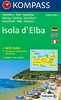
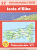
Elba`s Beaches 25K Ed. Multigraphic Map

Elba on a double-sided map from Edizioni Multigraphic highlighting 143 beaches, many illustrated with colour photographs, and grading them into sandy, sand and shingle or rocky. The interior is shown on a detailed contoured map with the publishers’ characteristic, somewhat old-fashioned cartography based on the earlier style of the Italian topographic survey.Contours are at 25m intervals and some additional places of interest are highlighted. The map has no geographical coordinates or an index apart from the list of the beaches. Map legend includes English.
RIP - This product is no longer available on our network. It was last seen on 25.09.2019

This page now acts as a permanent archive for this product. Add more information using the comments box below to ensure it can still be found by future generations.

Use our search facility to see if it is available from an alternative contributor.
  • Availability: Out Of Stock
  • Supplier: Stanfords
  • SKU: 9788874651061
Availability: In Stock
£12.99

Product Description

Elba on a double-sided map from Edizioni Multigraphic highlighting 143 beaches, many illustrated with colour photographs, & grading them into sandy, sand & shingle or rocky. The interior is shown on a detailed contoured map with the publishers’ characteristic, somewhat old-fashioned cartography based on the earlier style of the Italian topographic survey. Contours are at 25m intervals & some additional places of interest are highlighted. The map has no geographical coordinates or an index apart from the list of the beaches. Map legend

Includes::
English.

Reviews/Comments

Add New

Intelligent Comparison

Oooops!
We couldn't find anything!
Perhaps this product's unique.... Or perhaps we are still looking for comparisons!
Click to bump this page and we'll hurry up.

Price History

Vouchers

No voucher codes found.
Do you know a voucher code for this product or supplier? Add it to Insights for others to use.

Facebook

Jargon Buster

Italian - A word used ot descibe something from Italy
Colour - The categorised spectrum of light visable to humans
Interior - The inside of something, usually what is not visible.

Supplier Information

Stanfords
Stanfords was established in 1853 and opened their iconic Covent Garden flagship store in 1901. They have become the top retailer of maps, travel books and accessories in the UK and arguably offer the largest selection of maps and travel books worldwide. Famous names such as Captain Robert Falcon Scott, Ranulph Fiennes and Michael Palin have purchased from Stanfords. They now have a shop in Bristol and both stores together with other venues operate a calendar of events including talks, book signings and exhibitions. As a specialist map retailer, the map selection is comprehensive and includes road maps, street maps and walking maps from worldwide destinations, as well as a selection of world atlases and wall maps. Books include travel guides and travel literature. Stanfords also stock globes, from miniatures made of blue marble to magnificent floor-standing globes. The website features a selection of interesting articles on travel topics.
Page Updated: 2023-11-12 20:15:36

Community Generated Product Tags

Oh No! The productWIKI community hasn't generated any tags for this product yet!
Menu