
 United Kingdom
 France
 Germany
 Netherlands
 Sweden
 USA
USA
 Italy
Italy
 Spain
Spain
More From Contributor


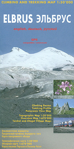
Elbrus
Elbrus on an excellent map from the Swiss-based Climbing Map publishers, combining topographic coverage at 1:50, 000 with an overview map of the region, a route profile, drawings of south and north faces, a panorama map, etc.On one side is a topographic map of Elbrus at 1:50, 000, centred on the peak and showing access to it both from the Baksan Valley in the south and from Dzhylysu along the northern approach route. Local roads, 4WD tracks and trails are marked, as well as gondola and chair lifts from the valley where settlements are annotated with icons indicating various facilities such as restaurants and food shops, banks and medical help, petrol stations, etc. The northern and the southern climbing routes are highlighted on the map and annotated to show camping areas. On
the reverse there are drawings of the south and the north face of Elbrus indicating, as appropriate, the routes with variants, camping areas and gondola access, plus providing a description of each route. The southern approach from Azau is shown on a route profile at 250m stages.This title also provides: - a panel of GPS waypoints for the two routes and other locations on the map- an overview map of the region showing access to the Elbrus area from Mineralnye Vody, Pyatigorsk and Nalchik- plans of Terskol, Cheget and Azau annotated with accommodation and other facilities- Elbrus Chronicle with history since 1829- a panorama map of the Caucasus looking south with Mount Ararat in the distance- photos of local flowers All place names are given in both Cyrillic and Latin alphabets. Map
legend and all the text include English.

Product Description
Reviews/Comments
Add New
Intelligent Comparison
Archived Product
Elbrus Stanfords
£6.95
Vouchers
No voucher codes found.
Do you know a voucher code for this product or supplier? Add it to Insights for others to use.
Do you know a voucher code for this product or supplier? Add it to Insights for others to use.
 Denmark