
 United Kingdom
 France
 Germany
 Netherlands
 Sweden
 USA
USA
 Italy
Italy
 Spain
Spain
More From Contributor


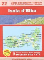
Elba L`Escursionista Editore
Elba at 1:25, 000 on a contoured and GPS-compatible map from L’Escursionista Editore prominently highlighting local trails and longer routes, shown where appropriate with their waymaking symbols and/or official numbers, plus a 32-page English language booklet on the Grande Traversata Elbana including accommodation.Topography of the island is presented by contours at 25m intervals with spot heights, relief shading, plus colouring for woodlands. The map shows local paths and mule tracks, indicating narrow or poorly marked trails and sections passable only when the sea is calm. Where appropriate, waymarked routes are annotated with their colours/signs and/or official numbers. Two longer routes are highlighted: the GTE – Grande Traversata Elbana through the interior and the Tour
delle Coste. Also marked are locations with mountain bike trails graded according to the degree of difficulty. The map has a 1-km UTM grid. Map legend includes English.Accompanying 32-page booklet in English describes the GTE in four stages and provides contact details for accommodations and other useful numbers. A table shows locations with accommodation, restaurants, grocery shops, cash dispensers and bus stops.
delle Coste. Also marked are locations with mountain bike trails graded according to the degree of difficulty. The map has a 1-km UTM grid. Map legend includes English.Accompanying 32-page booklet in English describes the GTE in four stages and provides contact details for accommodations and other useful numbers. A table shows locations with accommodation, restaurants, grocery shops, cash dispensers and bus stops.

Product Description
Reviews/Comments
Add New
Vouchers
No voucher codes found.
Do you know a voucher code for this product or supplier? Add it to Insights for others to use.
Do you know a voucher code for this product or supplier? Add it to Insights for others to use.
 Denmark