
 United Kingdom
 France
 Germany
 Netherlands
 Sweden
 USA
USA
 Italy
Italy
 Spain
Spain
More From Contributor


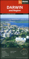
Darwin And Region Hema
Darwin and Region in a series of maps from Hema presenting Australia’s main cities with three maps: a detailed street plan of the central area, a road map of the city with its outer suburbs, plus a map of the wider surrounding region for out-of-town excursions. The Darwin map has on one side a street plan of city centre highlighting locations of 17 places of interest and 28 hotels, plus an indexed map of the city and its suburbs at 1:25, 000, extending south to include the Charles Darwin National Park. On the reverse is a road map of the Darwin Region (not indexed) at approx. 1:1, 500, 000 including the whole of the Kakadu National Park and extending south along the Stuart Highway to Mataranka. This title additionally provides indexed maps of Palmerston (1:25, 000) and Howard Springs
– Humpty Doo (1:75, 000).Both the suburban and the regional maps show the road network indicating unsurfaced roads and tracks. Symbols mark roadside rest areas, campsites, accredited information centres, places of interest, etc. Topography is indicated by names of mountain ranges and selected peaks, plus rivers and lakes; national and state parks, conservation areas and reserves are all highlighted. The suburban map also shows suburb names with their postal codes.To see other titles in this series please click on the series link.
– Humpty Doo (1:75, 000).Both the suburban and the regional maps show the road network indicating unsurfaced roads and tracks. Symbols mark roadside rest areas, campsites, accredited information centres, places of interest, etc. Topography is indicated by names of mountain ranges and selected peaks, plus rivers and lakes; national and state parks, conservation areas and reserves are all highlighted. The suburban map also shows suburb names with their postal codes.To see other titles in this series please click on the series link.

Product Description
Reviews/Comments
Add New
Vouchers
No voucher codes found.
Do you know a voucher code for this product or supplier? Add it to Insights for others to use.
Do you know a voucher code for this product or supplier? Add it to Insights for others to use.
 Denmark