
 United Kingdom
 France
 Germany
 Netherlands
 Sweden
 USA
USA
 Italy
Italy
 Spain
Spain
More From Contributor

Dartmoor Walking
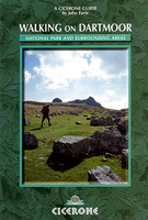
John Earle’s Cicerone guide to Walking on Dartmoor explores one of England’s favourite National Park walking destinations as well as its surrounding areas. Dartmoor has been referred to as one of the last great wildernesses in the country, where it is possible to get further away from civilisation than anywhere else. Its wild, lonely and remote areas of uplands and mountains, even in holiday periods, make it ideal walking country.The guide is organized into five sections - the South Moor, Widecombe walks, the North-East Moor, the North-West Moor and other Long walks taking in a total of 43 walking experiences. Each walk has a distance and difficulty rating at the start to help walkers plan their routes and the guide also allows for those of different abilities. An extensive
introduction includes essential information for any visitor- details on the geology and formation of Dartmoor, its legends and history as well as practical information on maps and compasses, equipment, clothing, tips on walking and climbing and the unique curiosity of the Dartmoor letterbox. Detailed route descriptions are accompanied by Ordnance Survey extracts mapping the route as well as colour photographs illustrating some of the highlights of the region.
introduction includes essential information for any visitor- details on the geology and formation of Dartmoor, its legends and history as well as practical information on maps and compasses, equipment, clothing, tips on walking and climbing and the unique curiosity of the Dartmoor letterbox. Detailed route descriptions are accompanied by Ordnance Survey extracts mapping the route as well as colour photographs illustrating some of the highlights of the region.

Product Description
Reviews/Comments
Add New
Vouchers
No voucher codes found.
Do you know a voucher code for this product or supplier? Add it to Insights for others to use.
Do you know a voucher code for this product or supplier? Add it to Insights for others to use.
 Denmark