
 United Kingdom
 France
 Germany
 Netherlands
 Sweden
 USA
USA
 Italy
Italy
 Spain
Spain
More From Contributor


Cyprus
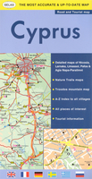
Indexed road map of Cyprus from the Nicosia based cartographic publishers Selas, with street plans of main cities and resorts indexed for main places of interest, an enlargement for the Troodos Mountains, maps of various nature trails, etc.The main map at 1:250, 000 has altitude colouring to give a general impression of the island’s topography. Road network includes unpaved roads and indicates locations of petrol stations. A wide range of symbols highlights various facilities, including accommodation and numerous restaurants, beaches, sport and recreational facilities, archaeological sites and other places of interest, etc. The overprint is limited to the Greek park of the island. Place names are shown in Latin alphabet only, with old Greek names used in Northern Cyprus. The
map has an index with a separate list of places of interest. Margin ticks give latitude and longitude at 30’ intervals.Enlargements at scales around 1:50, 000/75, 000 show waymarked nature trails in the central part of the Troodos mountains, Stavros mountains, plus on Akamas and Gkreko peninsulas. These maps are not contoured but have altitude colouring and show local landmarks. On the reverse, an enlargement at 1:100, 000 shows in greater detail the road network and various facilities in the whole of the Troodos mountains. Large street plans cover the central areas of Nicosia, Larnaka, Limassol and Pafos, indicating one way streets, petrol stations and banks, as well as accommodation, places of interest and various facilities all indexed. Similarly annotated and indexed insets
cover Agia Napa, Eastern Larnaka Beach and Protoras. Also included is a distance table. Main map legend is multilingual, including English; all indexes are in English only.

Product Description
Reviews/Comments
Add New
Intelligent Comparison
Archived Product
Cyprus Stanfords
£4.99
Archived Product
Cyprus Stanfords
£9.50
Archived Product
Cyprus Stanfords
£8.95
Archived Product
Cyprus Stanfords
£16.95
Archived Product
Cyprus Stanfords
£11.19
Archived Product
Cyprus Stanfords
£12.99
Archived Product
Cyprus Stanfords
£11.19
Archived Product

Crush Stanfords
£7.99
Vouchers
No voucher codes found.
Do you know a voucher code for this product or supplier? Add it to Insights for others to use.
Do you know a voucher code for this product or supplier? Add it to Insights for others to use.
 Denmark