
 United Kingdom
 France
 Germany
 Netherlands
 Sweden
 USA
USA
 Italy
Italy
 Spain
Spain
More From Contributor
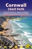


Cornwall From The Coast Path
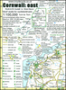
In 2007, Mike Kent fulfilled a long-standing ambition to walk the whole of the coast path of his Cornish homeland, from Marsland to Cremyll. During the 16-day journey, walking for up to 14 hours each day, and occasionally camping wild on remote and rugged cliffs, Mike recorded his thoughts and observations about various things Cornish. On his return, Mike and Merryn Kent dug deeper to uncover more about the places and people, landscapes and wildlife that caught his imagination along the way. Some are as world famous as Tintagel Castle and the tin mines of Levant. Others, like the cliffside hut built by poet and playwright Robert Duncan, are equally fascinating but barely known. Handsomely illustrated with many photographs and maps, this book aims to capture the authors' shared
passion for Cornwall's rich coastal heritage.
passion for Cornwall's rich coastal heritage.
Product Description
Reviews/Comments
Add New
Vouchers
No voucher codes found.
Do you know a voucher code for this product or supplier? Add it to Insights for others to use.
Do you know a voucher code for this product or supplier? Add it to Insights for others to use.
 Denmark