More From Contributor

£7.99
Cornwall in the Short Walks guide series, produced in association with Ordnance Survey & published by Crimson; comprising a range of walking guides to popular British destinations. Each title

Includes::
20 varied walks that are suitable for walkers of all ages & abilities & is accompanied by detailed Explorer 1:25, 000 Ordnance Survey mapping with colour-coded marked routes. The guides are structured in three main sections with different levels of difficulty- short & easy walks, those of modest length that may include uphill walking & more challenging routes that may be longer & over more rugged terrain- covering a total of 20 walks. Each walk has a mini summary & an information box with details of starting points, distance, approximate time, parking & any individual route features. There is also information on refreshments, local transport & public toilets en route. Appendices provide further useful information on walking safety, GPS, the Countryside Code, local organisations & Ordnance Survey maps.

...
Archived Product
£2.95
Cornwall 1610 Replica Map by the Old Map Company is a reproduction of the map created for the famous atlas of the period by the master map maker John Speede Esq. The Old Map Company has recreated the antique maps of British counties, European cities & World countries originally crafted by master map maker John Speede Esq. whose work had accuracy & quality not surpassed for centuries. Each map is treated & presented on specially crafted paper then h&-treated giving it texture & an aged appearance before being beautifully engraved & detailed. ...
Archived Product
£20.00
Cornwall in a series of cloth-backed reproductions from the Old Folding Maps of county maps published in late 19th century by Letts, Son & Co, with colouring & symbols providing a wealth of information, including towns where County Courts & Quarter Sessions are held, municipal boroughs, parliamentary county & borough boundaries with the number of returnable Members, etc. Letts county maps present each county with colouring indicating its parliamentary divisions & show a large number of smaller towns & villages. Railways are prominently highlighted; on roads “dangerous hills” are marked. Other information

Includes::
distance from London of main towns, market days, post towns, coast guard & life boat stations, etc. Each title also gives county statistics: population, area in acres, gross rental, inhabited houses, poor rate, & the number of paupers (!). Where appropriate, hachures are used to show the topography. The area outside the county boundary is not coloured but main towns plus road & rail connections are marked. Each map is backed onto cloth & presented folded in a colourful case covered with a unique design marbled paper. To see the list of all the titles in this series please click on the series link.

...
Archived Product
£6.99
Cornwall 30 Short walks is a handy pocket-sized box of 30 short walking routes in Cornwall. Contained within the box are 30 cards each with a short walking route, so walkers can easily take it with them on the walk for easy reference. All of the walks featured are between 1 & 4 miles long, allowing walkers to tackle them in a morning or afternoon. Key panels give details on distance, gradient, difficulty, surface & other practical advice. ...
Archived Product
£8.50
Cornwall Street Atlas from the Geographers` A-Z Map Company in a spiral-bound format slightly smaller than A4 & covering selected areas of the county at 1:16, 896 (3.75” to 1 mile). More detailed mapping at 1:8, 448 (7.5” to 1 mile) shows town centres of Looe, St. Ives & Plymouth. Current edition of this title was published in 2012. To see other titles in this series of A-Z county street atlases please click on the series link. A-Z also publish street atlases in a smaller A5 paperback format covering towns & cities with their surrounding areas
- for a list of titles in that series please search for SI00000932. Most A-Z county street atlases are in a spiral-bound format just smaller than A4 size, Most titles offer coverage of only the built-up areas, with selected titles covering the whole county
- as indicated in the individual descriptions & our area coverage images. Motorways plus A & B roads are highlighted by colouring & show route numbers. One way or restricted access streets, Park & Ride facilities & selected car parks are marked, as are locations of speed cameras. Also shown are selected cycleway routes. Where appropriate, A & B roads are annotated with selected house numbers for easier identification of addresses. Railway lines are shown with stations & level crossings. Colouring indicates different types of buildings: educational, hospitals & healthcare, industrial, leisure & recreational, shopping centres & markets, public buildings, & places of interest. Symbols mark locations of facilities usually indicated on street mapping: post offices, emergency services, public toilets, etc. Also marked are postcode & local authority boundaries. Each page has the lines & coordinates of the British National Grid. All the titles have a comprehensive index including, unless specified to the contrary in the description, separate entries for places of interest such as cultural & sport or recreational facilities, historical sites, nature reserves & gardens. Many titles include a separate list of hospitals & hospices in the area covered by the atlas.

...
Archived Product
£5.95
Cornwall at 1:158, 400 (1” to 2.5 miles) on an indexed Visitors’ road map from Geographers A-Z Map Company, highlighting numerous places of interest & providing street plans of 13 main towns, each with a list of sights & other useful tourist information. Road network is clearly presented, with driving distances marked on primary routes & on most A & B roads. Railway lines are shown with stations. A very wide range of symbols indicates various places of interest, many with their names prominently highlighted on the map, including campsites & caravan parks, historical & cultural sites, sport & recreational facilities, etc. Colouring indicates areas of Outstanding Natural Beauty. The index of towns & villages is supplemented by a separate list of the sites & facilities. Surrounding the map are panels with street plans showing the town centres of Bodmin, Bude, Falmouth, Fowley, Lauceston, Liskeard, Looe, Newquay, Padstow, Penzance, Plymouth, St. Ives & Truro. All show access to the centre, main sights & facilities, etc. & are accompanied by notes for visitors. Current 10th edition of this map was published in 2015. To see the list of titles on A-Z’s Visitor’ series please click on the series link. ...
Archived Product
£11.99
The stereotypical image of Cornwall is captivating enough: craggy cliffs, smugglers' coves & surfers hanging ten offshore. But peek behind the nautical bunting & sunburned tourists & you'll discover the real Cornwall
- a compelling land of myth, legend, dramatic scenery & rich culture
- The AA Guide to Cornwall gives you all you need to know to get the most out of your visit to this wonderful county. From open-air theatre to fish 'n' chips in Padstow, the Eden biospheres to the galleries of St Ives, each entry is packed with the very best sites to see, things to do, recommendations for eating & drinking, & places to explore nearby. With everything from local legends to must-see festivals & events, this authoritative & practical guide ensures you will never be lost for something to do.

...
Archived Product
£34.95
Cornwall & Scilly Isles Postcode Sector Map at 1:150, 000, encapsulated version, in a series of postcode sector maps showing the first part of the postcode & the first number of the second part, the Inward Code. Coverage extends to: north to Bradworthy, south to The Lizard & east to Tavistock. Map Marketing’s series of postcode sector maps covers Great Britain & Northern Ireland on 36 titles, each available only as a flat map, either on paper or encapsulated for greater durability. Presentation

Includes::
postcode changes in the most recent Royal Mail Postcode updates. The series covers Great Britain at 1:150, 000 (1” to 2.4 miles), with Northern Ireland shown at 1:210, 000 & London at two scales: 1:60, 000 for the area within the M25 & in more detail at 1:15, 000 for central London. Postcode area, district & sector boundaries & numbers/letters are shown in red, with County & Unitary Authority boundaries in green. The map base shows motorways, primary, ‘A’ & down to unclassified roads, with conurbation shapes & city plan insets showing street level detail for major cities. To see the list of all the titles in this series please click on the series link.LAMINATED & ENCAPSULATED WALL MAPS:- LAMINATED wall maps have a thin layer of plastic usually applied to the printed side only. They can be written on with suitable marker pens without any damage to the map but, unless laminated on both sides, they are not damp-proof.- ENCAPSULATED wall maps are sealed between two sheets of plastic. They are more rigid & heavier than laminated maps of the same size. They are damp-proof & do not crinkle in humid conditions. Encapsulation gives the map a shiny surface, similar to being displayed behind glass.- PLEASE NOTE: many publishers & retailers often use these two terms interchangeably. Our map titles & descriptions follow the definitions provided above.

...
Archived Product
£24.95
Cornwall & Scilly Isles Postcode Sector Map at 1:150, 000, paper version, in a series of postcode sector maps showing the first part of the postcode & the first number of the second part, the Inward Code. Coverage extends to: north to Bradworthy, south to The Lizard & east to Tavistock. Map Marketing’s series of postcode sector maps covers Great Britain & Northern Ireland on 36 titles, each available only as a flat map, either on paper or encapsulated for greater durability. Presentation

Includes::
postcode changes in the most recent Royal Mail Postcode updates. The series covers Great Britain at 1:150, 000 (1” to 2.4 miles), with Northern Ireland shown at 1:210, 000 & London at two scales: 1:60, 000 for the area within the M25 & in more detail at 1:15, 000 for central London. Postcode area, district & sector boundaries & numbers/letters are shown in red, with County & Unitary Authority boundaries in green. The map base shows motorways, primary, ‘A’ & down to unclassified roads, with conurbation shapes & city plan insets showing street level detail for major cities. To see the list of all the titles in this series please click on the series link.

...
Archived Product

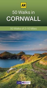
Cornwall 40 Short Walks

This compact and handy guide to short walks in Cornwall features walks between one and four miles long which can be covered in a morning or afternoon. There is an introduction for each walk giving background on the area, its history, wildlife and other points of interest; plus key information panels providing a summary of distance, time, gradient and ascent, level of difficulty, type of surface and access, landscape, dog friendliness, refreshments, parking and public toilets. Each walk has a highly detailed map and clear, easy-to-follow route directions.
RIP - This product is no longer available on our network. It was last seen on 25.09.2019

This page now acts as a permanent archive for this product. Add more information using the comments box below to ensure it can still be found by future generations.

Use our search facility to see if it is available from an alternative contributor.
  • External links may include paid for promotion
  • Availability: Out Of Stock
  • Supplier: Stanfords
  • SKU: 9780749569013
Availability: In Stock
£9.99

Product Description

This compact & handy guide to short walks in Cornwall features walks between one & four miles long which can be covered in a morning or afternoon. There is an introduction for each walk giving background on the area, its history, wildlife & other points of interest; plus key information panels providing a summary of distance, time, gradient & ascent, level of difficulty, type of surface & access, landscape, dog friendliness, refreshments, parking & public toilets. Each walk has a highly detailed map & clear, easy-to-follow route directions.

Reviews/Comments

Add New

Price History

Vouchers

No voucher codes found.
Do you know a voucher code for this product or supplier? Add it to Insights for others to use.

Facebook

Jargon Buster

compact - Carefuly designed to ensure an item has a minimal physical size
Key - A physical or virtual device or code used for opening something
History - Anything that happens in the past. An acedemic subject.
Compact - something that has a lot combined within a small space.

Supplier Information

Stanfords
Stanfords was established in 1853 and opened their iconic Covent Garden flagship store in 1901. They have become the top retailer of maps, travel books and accessories in the UK and arguably offer the largest selection of maps and travel books worldwide. Famous names such as Captain Robert Falcon Scott, Ranulph Fiennes and Michael Palin have purchased from Stanfords. They now have a shop in Bristol and both stores together with other venues operate a calendar of events including talks, book signings and exhibitions. As a specialist map retailer, the map selection is comprehensive and includes road maps, street maps and walking maps from worldwide destinations, as well as a selection of world atlases and wall maps. Books include travel guides and travel literature. Stanfords also stock globes, from miniatures made of blue marble to magnificent floor-standing globes. The website features a selection of interesting articles on travel topics.
Page Updated: 2023-11-12 20:15:36

Community Generated Product Tags

Oh No! The productWIKI community hasn't generated any tags for this product yet!
Menu