More From Contributor

£20.00
Cornwall in a series of cloth-backed reproductions from the Old Folding Maps of county maps published in late 19th century by Letts, Son & Co, with colouring & symbols providing a wealth of information, including towns where County Courts & Quarter Sessions are held, municipal boroughs, parliamentary county & borough boundaries with the number of returnable Members, etc. Letts county maps present each county with colouring indicating its parliamentary divisions & show a large number of smaller towns & villages. Railways are prominently highlighted; on roads “dangerous hills” are marked. Other information

Includes::
distance from London of main towns, market days, post towns, coast guard & life boat stations, etc. Each title also gives county statistics: population, area in acres, gross rental, inhabited houses, poor rate, & the number of paupers (!). Where appropriate, hachures are used to show the topography. The area outside the county boundary is not coloured but main towns plus road & rail connections are marked. Each map is backed onto cloth & presented folded in a colourful case covered with a unique design marbled paper. To see the list of all the titles in this series please click on the series link.

...
Archived Product
£6.99
Cornwall 30 Short walks is a handy pocket-sized box of 30 short walking routes in Cornwall. Contained within the box are 30 cards each with a short walking route, so walkers can easily take it with them on the walk for easy reference. All of the walks featured are between 1 & 4 miles long, allowing walkers to tackle them in a morning or afternoon. Key panels give details on distance, gradient, difficulty, surface & other practical advice. ...
Archived Product
£9.99
This compact & handy guide to short walks in Cornwall features walks between one & four miles long which can be covered in a morning or afternoon. There is an introduction for each walk giving background on the area, its history, wildlife & other points of interest; plus key information panels providing a summary of distance, time, gradient & ascent, level of difficulty, type of surface & access, landscape, dog friendliness, refreshments, parking & public toilets. Each walk has a highly detailed map & clear, easy-to-follow route directions. ...
Archived Product
£8.50
Cornwall Street Atlas from the Geographers` A-Z Map Company in a spiral-bound format slightly smaller than A4 & covering selected areas of the county at 1:16, 896 (3.75” to 1 mile). More detailed mapping at 1:8, 448 (7.5” to 1 mile) shows town centres of Looe, St. Ives & Plymouth. Current edition of this title was published in 2012. To see other titles in this series of A-Z county street atlases please click on the series link. A-Z also publish street atlases in a smaller A5 paperback format covering towns & cities with their surrounding areas
- for a list of titles in that series please search for SI00000932. Most A-Z county street atlases are in a spiral-bound format just smaller than A4 size, Most titles offer coverage of only the built-up areas, with selected titles covering the whole county
- as indicated in the individual descriptions & our area coverage images. Motorways plus A & B roads are highlighted by colouring & show route numbers. One way or restricted access streets, Park & Ride facilities & selected car parks are marked, as are locations of speed cameras. Also shown are selected cycleway routes. Where appropriate, A & B roads are annotated with selected house numbers for easier identification of addresses. Railway lines are shown with stations & level crossings. Colouring indicates different types of buildings: educational, hospitals & healthcare, industrial, leisure & recreational, shopping centres & markets, public buildings, & places of interest. Symbols mark locations of facilities usually indicated on street mapping: post offices, emergency services, public toilets, etc. Also marked are postcode & local authority boundaries. Each page has the lines & coordinates of the British National Grid. All the titles have a comprehensive index including, unless specified to the contrary in the description, separate entries for places of interest such as cultural & sport or recreational facilities, historical sites, nature reserves & gardens. Many titles include a separate list of hospitals & hospices in the area covered by the atlas.

...
Archived Product
£11.99
The stereotypical image of Cornwall is captivating enough: craggy cliffs, smugglers' coves & surfers hanging ten offshore. But peek behind the nautical bunting & sunburned tourists & you'll discover the real Cornwall
- a compelling land of myth, legend, dramatic scenery & rich culture
- The AA Guide to Cornwall gives you all you need to know to get the most out of your visit to this wonderful county. From open-air theatre to fish 'n' chips in Padstow, the Eden biospheres to the galleries of St Ives, each entry is packed with the very best sites to see, things to do, recommendations for eating & drinking, & places to explore nearby. With everything from local legends to must-see festivals & events, this authoritative & practical guide ensures you will never be lost for something to do.

...
Archived Product
£34.95
Cornwall & Scilly Isles Postcode Sector Map at 1:150, 000, encapsulated version, in a series of postcode sector maps showing the first part of the postcode & the first number of the second part, the Inward Code. Coverage extends to: north to Bradworthy, south to The Lizard & east to Tavistock. Map Marketing’s series of postcode sector maps covers Great Britain & Northern Ireland on 36 titles, each available only as a flat map, either on paper or encapsulated for greater durability. Presentation

Includes::
postcode changes in the most recent Royal Mail Postcode updates. The series covers Great Britain at 1:150, 000 (1” to 2.4 miles), with Northern Ireland shown at 1:210, 000 & London at two scales: 1:60, 000 for the area within the M25 & in more detail at 1:15, 000 for central London. Postcode area, district & sector boundaries & numbers/letters are shown in red, with County & Unitary Authority boundaries in green. The map base shows motorways, primary, ‘A’ & down to unclassified roads, with conurbation shapes & city plan insets showing street level detail for major cities. To see the list of all the titles in this series please click on the series link.LAMINATED & ENCAPSULATED WALL MAPS:- LAMINATED wall maps have a thin layer of plastic usually applied to the printed side only. They can be written on with suitable marker pens without any damage to the map but, unless laminated on both sides, they are not damp-proof.- ENCAPSULATED wall maps are sealed between two sheets of plastic. They are more rigid & heavier than laminated maps of the same size. They are damp-proof & do not crinkle in humid conditions. Encapsulation gives the map a shiny surface, similar to being displayed behind glass.- PLEASE NOTE: many publishers & retailers often use these two terms interchangeably. Our map titles & descriptions follow the definitions provided above.

...
Archived Product
£24.95
Cornwall & Scilly Isles Postcode Sector Map at 1:150, 000, paper version, in a series of postcode sector maps showing the first part of the postcode & the first number of the second part, the Inward Code. Coverage extends to: north to Bradworthy, south to The Lizard & east to Tavistock. Map Marketing’s series of postcode sector maps covers Great Britain & Northern Ireland on 36 titles, each available only as a flat map, either on paper or encapsulated for greater durability. Presentation

Includes::
postcode changes in the most recent Royal Mail Postcode updates. The series covers Great Britain at 1:150, 000 (1” to 2.4 miles), with Northern Ireland shown at 1:210, 000 & London at two scales: 1:60, 000 for the area within the M25 & in more detail at 1:15, 000 for central London. Postcode area, district & sector boundaries & numbers/letters are shown in red, with County & Unitary Authority boundaries in green. The map base shows motorways, primary, ‘A’ & down to unclassified roads, with conurbation shapes & city plan insets showing street level detail for major cities. To see the list of all the titles in this series please click on the series link.

...
Archived Product
£5.95
Cornwall is a special place. It generates a fierce pride among its native sons & daughters, & a passionate attachment from newcomers. Dreams of Cornwall can also inspire the Cornish overseas, descendants of nineteenth-century emigrants. But why? ” Cornwall & the Cornish” reveals the meanings of some of the places that inspire an identity with Cornwall. It explains why Cornwall is so often viewed as a distinctive place, & where the Cornish identity comes from. ...
Archived Product
£11.99
All-in-one hiking route guide, maps & accommodations for the 288-mile footpath that runs around the entire coastline of Cornwall: from Bude to Plymouth. Part 2 of the South West Coast Path, a 630-mile national trail from Minehead to Poole.

Includes::
142 large-scale maps (3 1/8 inches to 1 mile); 24 town plans & 16 overview maps. Full details of all accommodations & campsites, restaurants & pubs; plus full public transport information.

Includes::
day-walks. This second part of the South West Coast Path around the south-western tip of Britain

Includes::
some of the best coastal walking in Europe. With constantly changing scenery, the footpath takes in secluded coves, tiny fishing villages, rocky headlands, bustling resorts, wooded estuaries & golden surf-washed beaches. It is an area rich in wildlife with seabirds, wild flowers, dolphins & seals.. 24 town plans, 16 overview maps & 142 large-scale walking maps at just under 1:20, 000 showing route times, places to stay, places to eat, points of interest & much more. These are not general-purpose maps but fully-edited maps drawn by walkers for walkers.. Itineraries for all walkers whether walking the route in its entirety over a week to 10 days or sampling the highlights on day walks & short breaks. Practical information for all budgets camping, bunkhouses, hostels, B& Bs, pubs & hotels; where to stay, where to eat, what to see, plus detailed street plans. Comprehensive public transport information for all access points on the coast path. Flora & fauna four page full color flower guide, plus an illustrated section on local wildlife. Green hiking understanding the local environment & minimizing our impact on it.

Includes::
downloadable gps waypoints Plus extra colour sections: 16pp colour introduction & 16pp of colour mapping for stage sections (one stage per page) with trail profiles.”


...
Archived Product

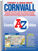
Cornwall A-Z Visitors` Map

Cornwall at 1:158, 400 (1” to 2.5 miles) on an indexed Visitors’ road map from Geographers A-Z Map Company, highlighting numerous places of interest and providing street plans of 13 main towns, each with a list of sights and other useful tourist information. Road network is clearly presented, with driving distances marked on primary routes and on most A and B roads. Railway lines are shown with stations. A very wide range of symbols indicates various places of interest, many with their names prominently highlighted on the map, including campsites and caravan parks, historical and cultural sites, sport and recreational facilities, etc. Colouring indicates areas of Outstanding Natural Beauty. The index of towns and villages is supplemented by a separate list of the sites and
facilities. Surrounding the map are panels with street plans showing the town centres of Bodmin, Bude, Falmouth, Fowley, Lauceston, Liskeard, Looe, Newquay, Padstow, Penzance, Plymouth, St. Ives and Truro. All show access to the centre, main sights and facilities, etc. and are accompanied by notes for visitors. Current 10th edition of this map was published in 2015. To see the list of titles on A-Z’s Visitor’ series please click on the series link.
RIP - This product is no longer available on our network. It was last seen on 25.09.2019

This page now acts as a permanent archive for this product. Add more information using the comments box below to ensure it can still be found by future generations.

Use our search facility to see if it is available from an alternative contributor.
  • Availability: Out Of Stock
  • Supplier: Stanfords
  • SKU: 9781843489542
Availability: In Stock
£5.95

Product Description

Cornwall at 1:158, 400 (1” to 2.5 miles) on an indexed Visitors’ road map from Geographers A-Z Map Company, highlighting numerous places of interest & providing street plans of 13 main towns, each with a list of sights & other useful tourist information. Road network is clearly presented, with driving distances marked on primary routes & on most A & B roads. Railway lines are shown with stations. A very wide range of symbols indicates various places of interest, many with their names prominently highlighted on the map, including campsites & caravan parks, historical & cultural sites, sport & recreational facilities, etc. Colouring indicates areas of Outstanding Natural Beauty. The index of towns & villages is supplemented by a separate list of the sites & facilities. Surrounding the map are panels with street plans showing the town centres of Bodmin, Bude, Falmouth, Fowley, Lauceston, Liskeard, Looe, Newquay, Padstow, Penzance, Plymouth, St. Ives & Truro. All show access to the centre, main sights & facilities, etc. & are accompanied by notes for visitors. Current 10th edition of this map was published in 2015. To see the list of titles on A-Z’s Visitor’ series please click on the series link.

Reviews/Comments

Add New

Intelligent Comparison

Oooops!
We couldn't find anything!
Perhaps this product's unique.... Or perhaps we are still looking for comparisons!
Click to bump this page and we'll hurry up.

Price History

Vouchers

No voucher codes found.
Do you know a voucher code for this product or supplier? Add it to Insights for others to use.

Facebook

Jargon Buster

Truro - A city and parish in Cornwall, England
Plymouth - A city on the coast of Devon
Natural - not manmade
Network - A link and communication between things. Often computers or people.
Road - a manmade lane or a path that is used to speed up travel.
Wide - Something with a large width.
Primary - the beginning of something, of chief importance.

Supplier Information

Stanfords
Stanfords was established in 1853 and opened their iconic Covent Garden flagship store in 1901. They have become the top retailer of maps, travel books and accessories in the UK and arguably offer the largest selection of maps and travel books worldwide. Famous names such as Captain Robert Falcon Scott, Ranulph Fiennes and Michael Palin have purchased from Stanfords. They now have a shop in Bristol and both stores together with other venues operate a calendar of events including talks, book signings and exhibitions. As a specialist map retailer, the map selection is comprehensive and includes road maps, street maps and walking maps from worldwide destinations, as well as a selection of world atlases and wall maps. Books include travel guides and travel literature. Stanfords also stock globes, from miniatures made of blue marble to magnificent floor-standing globes. The website features a selection of interesting articles on travel topics.
Page Updated: 2023-11-12 20:15:36

Community Generated Product Tags

Oh No! The productWIKI community hasn't generated any tags for this product yet!
Menu