
 United Kingdom
 France
 Germany
 Netherlands
 Sweden
 USA
USA
 Italy
Italy
 Spain
Spain
More From Contributor

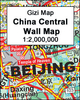

China Central Gizi Map
Central China in a series of five indexed maps at 1:2, 000, 000 from Gizi Map with attractive presentation of the country`s varied topography. Bold altitude colouring, with spot heights and names of mountain ranges and other geographical features, provides an excellent picture of the terrain. The maps in this series show various categories of roads including selected tracks, with intermediate driving distances marked on many routes. Railways, shipping and ferry lines, and local airports are also shown. Province boundaries are indicated and national parks are highlighted. Symbols marks landmarks and features such as tombs, monasteries, churches, temples, ruins, UNESCO sites including the Great Wall, and other places of interest.Names of main towns are also given in Chinese script
and within Tibet alternative versions are provided. Latitude and longitude lines are drawn at 1° intervals. Each title has an index on the reverse. Multilingual legend includes English.IN THIS TITLE: central and eastern China, extending from Shenyang in the north-east to Chongqing in the south and Yiayuguan in the west, including the Great Wall.
and within Tibet alternative versions are provided. Latitude and longitude lines are drawn at 1° intervals. Each title has an index on the reverse. Multilingual legend includes English.IN THIS TITLE: central and eastern China, extending from Shenyang in the north-east to Chongqing in the south and Yiayuguan in the west, including the Great Wall.
Product Description
Reviews/Comments
Add New
Vouchers
No voucher codes found.
Do you know a voucher code for this product or supplier? Add it to Insights for others to use.
Do you know a voucher code for this product or supplier? Add it to Insights for others to use.
 Denmark