
 United Kingdom
 France
 Germany
 Netherlands
 Sweden
 USA
USA
 Italy
Italy
 Spain
Spain
More From Contributor


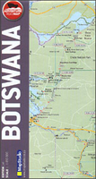
Botswana Map Studio Adventure Map
Botswana at 1:1, 650, 000 on an indexed road map from the South African publishers Map Studio, with the road network annotated with GPS waypoints for important locations, plus a street plan of Gaborone and an enlargement showing the nearby Victoria Falls area on the border of Zimbabwe and Zambia. The map shows Botswana’s topography by altitude colouring with names of deserts, salt pans, etc, and boundaries of national parks, game reserves and other protected areas. Road network indicates tarred and unsurfaced roads and includes cross-country tracks. Distances are shows on main and secondary routes, and locations of petrol stations are marked. GPS coordinates are indicated for important locations, e.g. entrance gates of protected areas and border crossing from/to the surrounding
countries. Symbols show locations with access by air, hotels, campsites and other tourist accommodation, and medical emergency facilities. The map has latitude and longitude lines at 1º intervals. The index is next to the map.Also provided is a street plan of central Gaborone highlighting important buildings/institutions, plus an enlargement presenting in greater detail the Victoria Falls area on the border of Zambia and Zimbabwe. The enlargement indicates main points of interest and includes small plans of Livingstone and of Victoria Falls Town.
countries. Symbols show locations with access by air, hotels, campsites and other tourist accommodation, and medical emergency facilities. The map has latitude and longitude lines at 1º intervals. The index is next to the map.Also provided is a street plan of central Gaborone highlighting important buildings/institutions, plus an enlargement presenting in greater detail the Victoria Falls area on the border of Zambia and Zimbabwe. The enlargement indicates main points of interest and includes small plans of Livingstone and of Victoria Falls Town.

Product Description
Reviews/Comments
Add New
Vouchers
No voucher codes found.
Do you know a voucher code for this product or supplier? Add it to Insights for others to use.
Do you know a voucher code for this product or supplier? Add it to Insights for others to use.
 Denmark