
 United Kingdom
 France
 Germany
 Netherlands
 Sweden
 USA
USA
 Italy
Italy
 Spain
Spain
More From Contributor


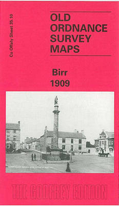
Birr 1909
Birr in 1909 in a fascinating series of reproductions of old Ordnance Survey plans in the Alan Godfrey Editions, ideal for anyone interested in the history of their neighbourhood or family. The map is double-sided for maximum coverage. The main map covers most of the town of Birr, with coverage from Pound Street southward to Moor Park and Seefin, and from Mount Palmer eastward to Clonoghil House. Features include the Observatory, Scurragh, Syngefield, Oxmantown Bridge, Presentation Brothers School, Birr Castle, Cumberland Square, John`s Place, Manor Saw Mill, Fair Green, St Brendan`s RC church, Industrial School, St Brendan`s church, Court House, Monastery, Union Workhouse, Elm Grove, etc. On the reverse is about half of the adjacent sheet 35.14 extending coverage
southward to include Crinkill, Whiteford Mill, Barracks, Whiteford Laundry, Millbrook Bridge, railway terminus, engine shed, etc. About the Alan Godfrey Editions of the 25” OS Series:Selected towns in Great Britain and Ireland are covered by maps showing the extent of urban development in the last decades of the 19th and early 20th century. The plans have been taken from the Ordnance Survey mapping and reprinted at about 15 inches to one mile (1:4, 340). On the reverse most maps have historical notes and many also include extracts from contemporary directories. Most maps cover about one mile (1.6kms) north/south, one and a half miles (2.4kms) across; adjoining sheets can be combined to provide wider coverage.FOR MORE INFORMATION AND A COMPLETE LIST OF ALL AVAILABLE TITLES PLEASE
CLICK ON THE SERIES LINK.

Product Description
Reviews/Comments
Add New
Intelligent Comparison
Archived Product
Birkdale 1909 Stanfords
£2.95
Archived Product

Birkdale 1909 Stanfords
£3.50
Archived Product
Ayr 1909 Stanfords
£3.50
Vouchers
No voucher codes found.
Do you know a voucher code for this product or supplier? Add it to Insights for others to use.
Do you know a voucher code for this product or supplier? Add it to Insights for others to use.
 Denmark