More From Contributor
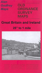
£8.99
Learning birdsong is not just a way to become a better bird-spotter. It is tuning in: a way of hearing the soundtrack of the planet earth... Why do birds sing? What are they trying to say? Birdsong is not just about natural history. It is also about our history. We got melody from the birds as we got rhythm from the womb. This vital book
- with a free podcast
- takes you from winter into deepest spring, teaching you to how recognise song after song as the chorus swells. You start with robin, & end up listening to nightingales. Along the way, you will learn something of the science of birdsong
- the difference between song & call, the physiology of songbirds, what birdsong tells us about evolution, & indeed the very beginnings of life itself. The aim is to give you a flying start in birdsong so that, after reading this book, you`ll be listening to order, not chaos, to Bach, not white noise. You will be more aware of the wild world, & better able to understand it.


...
Archived Product
£12.99
This is Birdwatchingwatching, a hilarious true story about fathers & sons, the birds (not the bees), & the eccentricities of two very different species. Alex Horne’s dad has always been a ‘twitcher’
- a birdwatcher, constantly on the look-out for his next bird sighting. Alex wasn’t so sure. But, determined to get to know his father better, Alex challenged him to a competitive Big Year: from January 1st to December 31st 2006, they would each attempt to see as many species of bird as possible, governed by the basic rules of birdwatching, plus a couple of their own: the birds had to be wild, free & alive; they had to actually see the birds; & they could travel anywhere in the world to do it. The one who saw the most birds over the course of 365 days would be declared the winner. Along the way, Alex would try to finally understand why his dad did what he did, & perhaps even ‘get into’ birdwatching himself. Following their year-long quest from Alex’s first bird sighting at home to birding breaks in Romania, a stag-weekend spent twitching in Wales & a penguin-spotting trip to South Africa, this is the charming story of a father & son, of manliness, obsessive behaviour, families & friendship. It’s the story of birdwatching told from the outsider’s point of view.
...
Archived Product
£6.99
Bou loves the floating library. But
- oh no!
- his favourite book is missing. Who could have it? A wonderfully vibrant picture

...
Archived Product
£7.99
There is the secret of Birdy`s dead grandmother`s cat. How the boys tortured her & Birdy Flynn had to drown her in the river to stop her suffering. There`s the secret of Mrs. Cope, the popular teacher, who took advantage of Birdy. & the secret of Gypsy Girl at school who Birdy likes, but can`t mention. Because Birdy`s greatest secret could change everything.. . In this luminescent, sad & funny portrayal of a young person growing up amid an imperfect family, Helen Donohoe has created a beautifully nuanced & deeply felt novel. Whatever their own story, every reader will recognise in Birdy their own struggle to find their place in the world. ...
Archived Product
£2.95
Birkdale in 1909 in a fascinating series of reproductions of old Ordnance Survey plans in the Alan Godfrey Editions, ideal for anyone interested in the history of their neighbourhood or family. Selected towns in Great Britain & Ireland are covered by maps showing the extent of urban development in the last decades of the 19th & early 20th century. In this title: the map covers the southern part of Southport, & Birkdale. Coverage extends from Stanley Avenue northward to Westcliffe Road, & from Warwick Street westward to the shore. This is mainly a residential map with many streets of housing, but other features include the Cheshire Lines Railway with Palace station, LYR railway with Birkdale station, Smedley Hydropathic, Bickerton House, livery stables, tramways, Victoria Brewery, Terra Nova, Palace Hotel, convent etc. A good selection of street directory entries is on the reverse. About the Alan Godfrey Editions of the 25 ...
Archived Product
£23.99
Birkebeineren area in Norway in a series of GPS compatible recreational maps at 1:50, 000 with cartography from Norway’s topographic survey & additional tourist information. Contours lines are drawn at 20m intervals. The overprint varies from title to title, but

Includes::
local footpaths, in some cases distinguishing between easy & more difficult trails, as well as mountain huts & campsites. Many titles also indicate cycle or ski routes, other accommodation possibilities, sport & recreational facilities, including alpine skiing slopes, places of interest, etc. The maps have a UTM grid & margin ticks giving latitude & longitude. Map legend

Includes::
English. Several titles have on the reverse additional tourist information, although in most cases in Norwegian only. To see the list of Turkart maps at 1:50, 000 & links to Turkart series at 25K, 100K & Hiking Sets please click on the series link above.


...
Archived Product
£3.50
Birkenhead in 1909 in a fascinating series of reproductions of old Ordnance Survey plans in the Alan Godfrey Editions, ideal for anyone interested in the history of their neighbourhood or family. The map is double-sided. The main map covers a major central area of Birkenhead, stretching from Manor Hill eastward to Hamilton Square, & from Grange Road northward to Vittoria Dock. Features include Birkenhead Park, Claughton, Manor House, St John`s church, tramways, Haymarket, St Lawrence`s RC church, Egerton Dock, Morpeth Dock, Wallasey Dock, Vittoria Dock, railways into & around docks, LNWR Goods station, Birkenhead Warehouses, Duke Street Wharf, Cavendish Wharf, Cavendish Wharf Sidings, Birkenhead Park football ground, Mersey Cabinet Works, tram depot, Birkenhead Park station, St Ann`s church, Borough Hospital, etc. On the reverse is the adjacent map 13.04 which extends coverage eastward to the waterfront; features here include Birkenhead Iron Works, St Mary`s church, Clovers Graving Docks, Woodside Ferry, Woodside station, Woodside Ferry, Morpeth Branch Dock, GWR goods station, Wallasey Landing Stage, Wallasey Lairage, Woodside Lairage, etc. A street directory for Conway Street is also included. About the Alan Godfrey Editions of the 25” OS Series: Selected towns in Great Britain & Ireland are covered by maps showing the extent of urban development in the last decades of the 19th & early 20th century. The plans have been taken from the Ordnance Survey mapping & reprinted at about 15 inches to one mile (1:4, 340). On the reverse most maps have historical notes & many also include extracts from contemporary directories. Most maps cover about one mile (1.6kms) north/south, one & a half miles (2.4kms) across; adjoining sheets can be combined to provide wider coverage.FOR MORE INFORMATION & A COMPLETE LIST OF ALL AVAILABLE TITLES PLEASE CLICK ON THE SERIES LINK. ...
Archived Product
£6.39
A detailed topographic map of Birmingham from the Ordnance Survey Explorer series, covering Walsall, Solihull & Redditch. Edition A2 with minor changes; publication date March 2012 About this series: These highly detailed maps show all the administrative boundaries, settlements as small as isolated farms, the road network down to unfenced roads & country tracks, & field boundaries (hedges & drystone walls) which make navigation across the countryside much easier. Steep gradients on roads are indicated. Various landmarks, e.g. powerlines, archaeological sites, windmills, churches & lighthouses are shown & additional graphics indicate natural terrain features such as cliffs, scree, mud & vegetation variations. The contour interval is 5 metres in the lower parts of the country & 10 metres in the uplands, & spot heights are marked. Each map covers an area of 30 x 20km (i.e. approx. 19 x 12 miles), with some double-sided maps covering more, as indicated in the individual descriptions. The maps are fully GPS compatible, with the National Grid shown at 1km intervals & latitude & longitude indicated by margin ticks at 1'. The Explorer series has replaced the earlier, green-cover Pathfinder maps. The Explorer series is now complete & covers all of Engl&, Wales & Scotl&. Some sheets for popular areas like the National Parks are still branded as Outdoor Leisure (OL) maps, but are now included in this series as the cartography is the same as that in the Explorer Maps. The Explorer maps offer a substantial improvement on the Pathfinder series, with greater use of colour, larger area per map, & stronger emphasis on information for ramblers & tourists. This series is ideal for walking & other outdoor pursuits & each map shows a large amount of information for ramblers & tourists. Public rights of way are shown (except in Scotland), together with other routes with public access: National Trails & Recreational Paths, permitted paths & bridleways, & selected cycle routes. Open access land created under the Countryside & Rights of Way Act 2000 is marked. Tourist information

Includes::
caravan & camp sites, Park & Ride locations, recreation/leisure/sport centres, museums, historic buildings, English Heritage & National Trust sites, rural pubs, etc. The map legend is in English only, except for the tourist information content which is also in French & German.

...
Archived Product
£16.99
Birmingham & the Heart of England Waterways Guide published by Collins under their Nicholson imprint in a series of spiral-bound guides to Britain’s inland waterways. Coverage

Includes::
Ashby Canal, Birmingham Canal Navigations – Main Line, Birmingham & Fazeley Canal, Coventry Canal, Erewash Canal, Grand Union Canal
- Leicester Section & the River Soar, Grand Union Canal – Main Line, Oxford Canal, Staffordshire & Worcestershire Canal: North, Stratford-on-Avon Canal, Worcester & Birmingham Canal, & Trent & Mersey Canal. Guides in the Nicholson series have Ordnance Survey’s mapping from the Landranger series with an overprint highlighting the waterways & adding locks with their names, number & rise, also staircase locks, weirs, turning points, various facilities such as overnight moorings, water points, sewage & refuse disposal, food shops, public houses & restaurants, etc. Towpaths, which can also be used by hikers or cyclists, are clearly marked. The guides provide descriptions of towns & villages, contact details & where appropriate opening hours of local services, etc. Each guide also

Includes::
an introductory section with general advice, regulations & tips. Completing the series is a general map of Great Britain showing the country’s navigable waterways.


...
Archived Product
£3.99
Street by Street Birmingham Mini has been fully updated with a stylish new cover design, in a handy pocket size. Quick to navigate & easy-to-use, the maps clearly show AA recommended restaurants, pubs, hotels, one-way streets & car parks. Featuring a clever use of colour to ensure they can be read under street lighting, the Street by Street Birmingham Mini map is all you need to keep you on the move. ...
Archived Product

Birkdale 1909

Birkdale in 1909 in a fascinating series of reproductions of old Ordnance Survey plans in the Alan Godfrey Editions, ideal for anyone interested in the history of their neighbourhood or family. The map covers the southern part of Southport, and Birkdale. Coverage extends from Stanley Avenue northward to Westcliffe Road, and from Warwick Street westward to the shore. This is mainly a residential map with many streets of housing, but other features include the Cheshire Lines Railway with Palace station, LYR railway with Birkdale station, Smedley Hydropathic, Bickerton House, livery stables, tramways, Victoria Brewery, Terra Nova, Palace Hotel, convent, etc. A good selection of street directory entries is on the reverse. About the Alan Godfrey Editions of the 25” OS
Series:Selected towns in Great Britain and Ireland are covered by maps showing the extent of urban development in the last decades of the 19th and early 20th century. The plans have been taken from the Ordnance Survey mapping and reprinted at about 15 inches to one mile (1:4, 340). On the reverse most maps have historical notes and many also include extracts from contemporary directories. Most maps cover about one mile (1.6kms) north/south, one and a half miles (2.4kms) across; adjoining sheets can be combined to provide wider coverage.FOR MORE INFORMATION AND A COMPLETE LIST OF ALL AVAILABLE TITLES PLEASE CLICK ON THE SERIES LINK.
RIP - This product is no longer available on our network. It was last seen on 25.09.2019

This page now acts as a permanent archive for this product. Add more information using the comments box below to ensure it can still be found by future generations.

Use our search facility to see if it is available from an alternative contributor.
  • External links may include paid for promotion
  • Availability: Out Of Stock
  • Supplier: Stanfords
  • SKU: 9780850547894
Availability: In Stock
£3.50

Product Description

Birkdale in 1909 in a fascinating series of reproductions of old Ordnance Survey plans in the Alan Godfrey Editions, ideal for anyone interested in the history of their neighbourhood or family. The map covers the southern part of Southport, & Birkdale. Coverage extends from Stanley Avenue northward to Westcliffe Road, & from Warwick Street westward to the shore. This is mainly a residential map with many streets of housing, but other features include the Cheshire Lines Railway with Palace station, LYR railway with Birkdale station, Smedley Hydropathic, Bickerton House, livery stables, tramways, Victoria Brewery, Terra Nova, Palace Hotel, convent, etc. A good selection of street directory entries is on the reverse. About the Alan Godfrey Editions of the 25” OS Series: Selected towns in Great Britain & Ireland are covered by maps showing the extent of urban development in the last decades of the 19th & early 20th century. The plans have been taken from the Ordnance Survey mapping & reprinted at about 15 inches to one mile (1:4, 340). On the reverse most maps have historical notes & many also include extracts from contemporary directories. Most maps cover about one mile (1.6kms) north/south, one & a half miles (2.4kms) across; adjoining sheets can be combined to provide wider coverage.FOR MORE INFORMATION & A COMPLETE LIST OF ALL AVAILABLE TITLES PLEASE CLICK ON THE SERIES LINK.

Reviews/Comments

Add New

Intelligent Comparison

Oooops!
We couldn't find anything!
Perhaps this product's unique.... Or perhaps we are still looking for comparisons!
Click to bump this page and we'll hurry up.

Price History

Vouchers

No voucher codes found.
Do you know a voucher code for this product or supplier? Add it to Insights for others to use.

Facebook

Jargon Buster

Contemporary - Modern era design
Contemporary - A design reference to indicate post war modern design
Hotel - An establishment which provides lodging for a fee
History - Anything that happens in the past. An acedemic subject.
Road - a manmade lane or a path that is used to speed up travel.
Contemporary - An object that is living in the same time.
Ideal - Something that satisfies a perfect criteria.
Family - A group of people that live together made up from parents and children.

Supplier Information

Stanfords
Stanfords was established in 1853 and opened their iconic Covent Garden flagship store in 1901. They have become the top retailer of maps, travel books and accessories in the UK and arguably offer the largest selection of maps and travel books worldwide. Famous names such as Captain Robert Falcon Scott, Ranulph Fiennes and Michael Palin have purchased from Stanfords. They now have a shop in Bristol and both stores together with other venues operate a calendar of events including talks, book signings and exhibitions. As a specialist map retailer, the map selection is comprehensive and includes road maps, street maps and walking maps from worldwide destinations, as well as a selection of world atlases and wall maps. Books include travel guides and travel literature. Stanfords also stock globes, from miniatures made of blue marble to magnificent floor-standing globes. The website features a selection of interesting articles on travel topics.
Page Updated: 2023-11-12 20:15:36

Community Generated Product Tags

Oh No! The productWIKI community hasn't generated any tags for this product yet!
Menu