More From Contributor
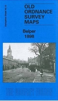
£8.99
Lila Langdon is twelve years old when she witnesses a family tragedy after her mother unveils her father`s surprise birthday present
- a tragedy that ends her childhood in India & precipitates a new life in Sussex with her Great-aunt Wilhelmina. From the darkest days of the British Raj through to the aftermath of the First World War, Belonging tells the interwoven story of three generations & their struggles to understand & free themselves from a troubled history steeped in colonial violence. It is a novel of secrets that unwind through Lila`s story, through her grandmother`s letters home from India & the diaries kept by her father, Henry, as he puzzles over the enigma of his birth & his stormy marriage to the mysterious Rebecca. Umi Sinha`s unforgettable debut is an intense, compelling & finely wrought epic of love & loss, of race & ethnicity, of homeland
- & of belonging.

...
Archived Product
£25.00
SHORTLISTED FOR THE BAILLIE GIFFORD PRIZE `A glittering gemstone of a book` The Times The Jewish story is a history that is about, & for, all of us. & in our own time of anxious arrivals & enforced departures, the Jews` search for a home is more startlingly resonant than ever. Belonging is a magnificent cultural history abundantly alive with energy, character & colour. It spans centuries & continents, from the Jews` expulsion from Spain in 1492 it navigates miracles & massacres, wandering, discrimination, harmony & tolerance; to the brink of the twentieth century &, it seems, a point of profound hope. It tells the stories not just of rabbis & philosophers but of a poetess in the ghetto of Venice; a boxer in Georgian England; a general in Ming China; an opera composer in nineteenth-century Germany. The story unfolds in Kerala & Mantua, the starlit hills of Galilee, the rivers of Colombia, the kitchens of Istanbul, the taverns of Ukraine & the mining camps of California. It sails in caravels, rides the stage coaches & the railways; trudges the dawn streets of London, hobbles along with the remnant of Napoleon`s ruined army. Through Schama`s passionate telling of this second chronicle in an epic tale, a history emerges of the Jewish people that feels it is the story of everyone, of humanity. ...
Archived Product
£7.99
It is the mid-1800s. At Sweet Home in Kentuckhy, an era is ending as slavery comes under attack from the abolitionists. The worlds of Halle & Paul D. are to be destroyed in a cataclysm of torment & agony. The world of Sethe, however, is to turn from one of love to one of violence & death
- the death of Sethe`s baby daughter Beloved, whose name is the single word on the tombstone, who died at her mother`s hands, & who will return to claim retribution.
...
Archived Product
£14.99
At the stroke of midnight on 20 May 2002, the Democratic Republic of Timor-Leste became the first new nation of the 21st century. From that moment, those who fought for independence have faced a challenge even bigger than shaking off Indonesian occupation: running a country of their own. * Beloved Land* picks up the story where world attention left off. Blending narrative history, travelogue, & personal reminiscences, Gordon Peake shows the daunting hurdles that the people of Timor-Leste must overcome to build a nation from scratch, & how much the international community has to learn if it is to help rather than hinder the process. Family politics, squabbles, power struggles, old romances, & even older grudges are woven into life in this land of intrigue & rumours in the most remarkable ways. Yet above all, * Beloved Land* is a story about the one million East Timorese who speak nearly 20 different languages, & who are exuberantly building their nation. It is also about the East Timorese diaspora in Northern Irel&. Written with verve & deep affection, the book brings the character of Timor-Leste to life unforgettably. ...
Archived Product
£18.99
Conbining gripping adventure writing with intimate memoir, Rick Ridgeway takes readers to the mysterious mountain domain of Tibet, & onto the remote corners of his past. Twenty years ago, in the wake of a massive & terrifying avalanche, Ridgeway cradled his dying friend Jonathan in his arms & pledged to keep watch over Jonathan's infant daughter Asia. Now Asia is a vibrant, headstrong young woman; hoping to help her connect with the father she never knew, Ridgeaway takes her to the Himalayas Jonathan so cherished. Together they search for the place where he died. Their trek through remote & forbidding terrain
- under constant threat from lethal storms & jumpy Chinese military patrols
- is a fitting backdrop for the precarious emotional journey that Ridgeway & Asia share, as they venture into alien landscapes of memory & self-discovery. Ultimately, the truths they both seek are revealed, not in the images of life long gone but in the bright promise of future possibility. In a stunning conclusion on a treacherous & wind-battered mountain face, both Ridgeway & his dead friend's daughter finally embrace the deepest realities of death & life.

...
Archived Product
£3.50
Belper in 1898 in a fascinating series of reproductions of old Ordnance Survey plans in the Alan Godfrey Editions, ideal for anyone interested in the history of their neighbourhood or family. The map is double-sided. The main map covers the centre of the town, stretching from Christ Church & the cotton mills eastward to Whitemoor Hall, & from Farlawn southward to King Street. Features include railway with station, Unity Mill, St Laurence`s Convent, St Peter`s church, Green Hall, St John`s church, The Gutter, Nottingham Road area, Market Place, etc. On the reverse is part of the adjacent sheet 45.01 extending coverage southward to include Park Foundry, Swainsleywood Farm, gas works, Goods Station, Belper Workhouse, Cowhill, Coppice Brook, etc. About the Alan Godfrey Editions of the 25” OS Series: Selected towns in Great Britain & Ireland are covered by maps showing the extent of urban development in the last decades of the 19th & early 20th century. The plans have been taken from the Ordnance Survey mapping & reprinted at about 15 inches to one mile (1:4, 340). On the reverse most maps have historical notes & many also include extracts from contemporary directories. Most maps cover about one mile (1.6kms) north/south, one & a half miles (2.4kms) across; adjoining sheets can be combined to provide wider coverage.FOR MORE INFORMATION & A COMPLETE LIST OF ALL AVAILABLE TITLES PLEASE CLICK ON THE SERIES LINK. ...
Archived Product
£14.50
Belt Pack (Mini) is a compact travel pack for the solo traveller to keep cards & documents safe & organised. The Belt Pack is zipped & comes with internal organiser pockets & pen loop. Internal pockets consist of a credit card slot & 2 EU passport sized slip in pockets, & there is a front zipped accessory pocket & Velcro pouch. Gusseted sides that prevent loose items from falling out when opened & a neck cord & belt loop are included. ...
Archived Product
£7.99
Belt Wallet operates on a hide & slide system to keep your money & valuables safe. The slim wallet is secured on to a belt & sits inconspicuously against the body, on your trouser waistb&. Belt Wallet is designed to hold cash, passport & credit cards. ...
Archived Product
£3.50
Belvedere in 1895 in a fascinating series of reproductions of old Ordnance Survey plans in the Alan Godfrey Editions, ideal for anyone interested in the history of their neighbourhood or family. Tthe map is double-sided to give maximum coverage. The main map covers an area from West Heath Road & Lessness Abbey eastward to Belvedere Park & Fox House Road, & southward to Erith Cemetery. Features include Abbey Wood (the actual wood), West Heath, Lessness Heath, All Saints church, Royal Alfred Institution. The original name for the area was Lessness Heath, the name Belvedere being adopted in 1858. Though quite a busy map, it still retains a semi-rural air, with the many Victorian houses surrounded by woodland & fields. On the reverse is half of Sheet 2.11, extending coverage westward to Bostall Heath, Bostall Wood, Shornell`s Wood & Plumstead Cemetery. About the Alan Godfrey Editions of the 25” OS Series: Selected towns in Great Britain & Ireland are covered by maps showing the extent of urban development in the last decades of the 19th & early 20th century. The plans have been taken from the Ordnance Survey mapping & reprinted at about 15 inches to one mile (1:4, 340). On the reverse most maps have historical notes & many also include extracts from contemporary directories. Most maps cover about one mile (1.6kms) north/south, one & a half miles (2.4kms) across; adjoining sheets can be combined to provide wider coverage.FOR MORE INFORMATION & A COMPLETE LIST OF ALL AVAILABLE TITLES PLEASE CLICK ON THE SERIES LINK. ...
Archived Product

Belper 1898

Belper in 1898 in a fascinating series of reproductions of old Ordnance Survey plans in the Alan Godfrey Editions, ideal for anyone interested in the history of their neighbourhood or family. Selected towns in Great Britain and Ireland are covered by maps showing the extent of urban development in the last decades of the 19th and early 20th century.In this title: the map is double-sided. The main map covers the centre of the town, with coverage stretching from Christ Church and the cotton mills eastward to Whitemoor Hall, and from Farlawn southward to King Street. Features include railway with station, Unity Mill, St Laurence's Convent, St Peter's church, Green Hall, St John's church, The Gutter, Nottingham Road area, Market Place, etc. On the reverse is part of the adjacent
sheet 45.01 extending coverage southward to include Park Foundry, Swainsleywood Farm, gas works, Goods Station, Belper Workhouse, Cowhill, Coppice Brook, etc. About the Alan Godfrey Editions of the 25
RIP - This product is no longer available on our network. It was last seen on 25.09.2019

This page now acts as a permanent archive for this product. Add more information using the comments box below to ensure it can still be found by future generations.

Use our search facility to see if it is available from an alternative contributor.
  • External links may include paid for promotion
  • Availability: Out Of Stock
  • Supplier: Stanfords
  • SKU: 9786000007430
Availability: In Stock
£2.95

Product Description

Belper in 1898 in a fascinating series of reproductions of old Ordnance Survey plans in the Alan Godfrey Editions, ideal for anyone interested in the history of their neighbourhood or family. Selected towns in Great Britain & Ireland are covered by maps showing the extent of urban development in the last decades of the 19th & early 20th century. In this title: the map is double-sided. The main map covers the centre of the town, with coverage stretching from Christ Church & the cotton mills eastward to Whitemoor Hall, & from Farlawn southward to King Street. Features include railway with station, Unity Mill, St Laurence's Convent, St Peter's church, Green Hall, St John's church, The Gutter, Nottingham Road area, Market Place, etc. On the reverse is part of the adjacent sheet 45.01 extending coverage southward to include Park Foundry, Swainsleywood Farm, gas works, Goods Station, Belper Workhouse, Cowhill, Coppice Brook, etc. About the Alan Godfrey Editions of the 25

Reviews/Comments

Add New

Price History

Vouchers

No voucher codes found.
Do you know a voucher code for this product or supplier? Add it to Insights for others to use.

Facebook

Jargon Buster

Cotton - A natural fibre grown on cotton plants
History - Anything that happens in the past. An acedemic subject.
King - The figure head of a monarch
Road - a manmade lane or a path that is used to speed up travel.
Cotton - A 100% natural fibre coming from a cotton boll.
Mill - A building which can grind grain into flour.
Hall - A room at the inside of an entrance of a house.
Ideal - Something that satisfies a perfect criteria.
Family - A group of people that live together made up from parents and children.

Supplier Information

Stanfords
Stanfords was established in 1853 and opened their iconic Covent Garden flagship store in 1901. They have become the top retailer of maps, travel books and accessories in the UK and arguably offer the largest selection of maps and travel books worldwide. Famous names such as Captain Robert Falcon Scott, Ranulph Fiennes and Michael Palin have purchased from Stanfords. They now have a shop in Bristol and both stores together with other venues operate a calendar of events including talks, book signings and exhibitions. As a specialist map retailer, the map selection is comprehensive and includes road maps, street maps and walking maps from worldwide destinations, as well as a selection of world atlases and wall maps. Books include travel guides and travel literature. Stanfords also stock globes, from miniatures made of blue marble to magnificent floor-standing globes. The website features a selection of interesting articles on travel topics.
Page Updated: 2023-11-12 20:15:36

Community Generated Product Tags

Oh No! The productWIKI community hasn't generated any tags for this product yet!
Menu