
 United Kingdom
 France
 Germany
 Netherlands
 Sweden
 USA
USA
 Italy
Italy
 Spain
Spain
More From Contributor


Belvedere 1895
Belvedere in 1895 in a fascinating series of reproductions of old Ordnance Survey plans in the Alan Godfrey Editions, ideal for anyone interested in the history of their neighbourhood or family. Tthe map is double-sided to give maximum coverage. The main map covers an area from West Heath Road and Lessness Abbey eastward to Belvedere Park and Fox House Road, and southward to Erith Cemetery. Features include Abbey Wood (the actual wood), West Heath, Lessness Heath, All Saints church, Royal Alfred Institution. The original name for the area was Lessness Heath, the name Belvedere being adopted in 1858. Though quite a busy map, it still retains a semi-rural air, with the many Victorian houses surrounded by woodland and fields. On the reverse is half of Sheet 2.11, extending coverage
westward to Bostall Heath, Bostall Wood, Shornell`s Wood and Plumstead Cemetery.About the Alan Godfrey Editions of the 25” OS Series:Selected towns in Great Britain and Ireland are covered by maps showing the extent of urban development in the last decades of the 19th and early 20th century. The plans have been taken from the Ordnance Survey mapping and reprinted at about 15 inches to one mile (1:4, 340). On the reverse most maps have historical notes and many also include extracts from contemporary directories. Most maps cover about one mile (1.6kms) north/south, one and a half miles (2.4kms) across; adjoining sheets can be combined to provide wider coverage.FOR MORE INFORMATION AND A COMPLETE LIST OF ALL AVAILABLE TITLES PLEASE CLICK ON THE SERIES LINK.
westward to Bostall Heath, Bostall Wood, Shornell`s Wood and Plumstead Cemetery.About the Alan Godfrey Editions of the 25” OS Series:Selected towns in Great Britain and Ireland are covered by maps showing the extent of urban development in the last decades of the 19th and early 20th century. The plans have been taken from the Ordnance Survey mapping and reprinted at about 15 inches to one mile (1:4, 340). On the reverse most maps have historical notes and many also include extracts from contemporary directories. Most maps cover about one mile (1.6kms) north/south, one and a half miles (2.4kms) across; adjoining sheets can be combined to provide wider coverage.FOR MORE INFORMATION AND A COMPLETE LIST OF ALL AVAILABLE TITLES PLEASE CLICK ON THE SERIES LINK.

Product Description
Reviews/Comments
Add New
Intelligent Comparison
Archived Product
Belper 1898 Stanfords
£2.95
Archived Product
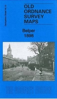
Belper 1898 Stanfords
£3.50
Vouchers
No voucher codes found.
Do you know a voucher code for this product or supplier? Add it to Insights for others to use.
Do you know a voucher code for this product or supplier? Add it to Insights for others to use.
 Denmark