
 United Kingdom
 France
 Germany
 Netherlands
 Sweden
 USA
USA
 Italy
Italy
 Spain
Spain
More From Contributor


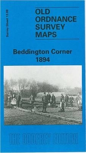
Beddington Corner 1894
Beddington Corner in 1894 in a fascinating series of reproductions of old Ordnance Survey plans in the Alan Godfrey Editions, ideal for anyone interested in the history of their neighbourhood or family. ”The River Wandle runs north to south through the centre of this map and most of the development of the area has taken place along its banks. The river provided the energy to turn the water wheels which powered the various mills and works established along the Wandle, many of which date from the 18th century.” So begins John Brown`s introduction to the map. The works include Eagle Leather Works, Wandle Tannery, Mitcham Leather Works, and there are also various watercress beds. The community of Beddington Corner is shown in a state of construction with roads such as Wolseley Road,
Wood Street and New Road partly built. The London Road runs north-south and almost parallel is the railway; Mitcham Junction station is at the top of the map. The map extends west to Greenwrythe Lane, and Ravensbury Park is in the north-western corner. Tramway Terrace is a reminder of the earlier Surrey Iron Railway.About the Alan Godfrey Editions of the 25” OS Series:Selected towns in Great Britain and Ireland are covered by maps showing the extent of urban development in the last decades of the 19th and early 20th century. The plans have been taken from the Ordnance Survey mapping and reprinted at about 15 inches to one mile (1:4, 340). On the reverse most maps have historical notes and many also include extracts from contemporary directories. Most maps cover about one mile (1.6kms)
north/south, one and a half miles (2.4kms) across; adjoining sheets can be combined to provide wider coverage.FOR MORE INFORMATION AND A COMPLETE LIST OF ALL AVAILABLE TITLES PLEASE CLICK ON THE SERIES LINK.

Product Description
Reviews/Comments
Add New
Intelligent Comparison
Archived Product

Teddington Lock 1894 Stanfords
£3.50
Vouchers
No voucher codes found.
Do you know a voucher code for this product or supplier? Add it to Insights for others to use.
Do you know a voucher code for this product or supplier? Add it to Insights for others to use.
 Denmark