
 United Kingdom
 France
 Germany
 Netherlands
 Sweden
 USA
USA
 Italy
Italy
 Spain
Spain
More From Contributor


Bed In A Tree
Bed in a Tree offers a handpicked selection of 27 weird and wonderful hotels from around the world each offering an unforgettable and original place to stay. There are hotels to suit a range of travelling budgets and interests, including the Ice Hotel in Sweden, an actual bed in a tree in South Africa, an aeroplane in New Zealand, a snooze in a suitcase in Germany and even a night in a stone pineapple in Scotland! The guide contains a large array of photographs
Product Description
Reviews/Comments
Add New
Intelligent Comparison
Archived Product
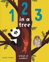
1 2 3 In A Tree Stanfords
£6.99
Vouchers
No voucher codes found.
Do you know a voucher code for this product or supplier? Add it to Insights for others to use.
Do you know a voucher code for this product or supplier? Add it to Insights for others to use.
 Denmark