
 United Kingdom
 France
 Germany
 Netherlands
 Sweden
 USA
USA
 Italy
Italy
 Spain
Spain
More From Contributor

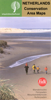
Baronie Van Breda
Baronie van Breda area of the Netherlands in a series of walking and cycling maps at 1:25, 000 – 1:35, 000, published by Falk BV in cooperation with Staatsbosbeheer – Dutch government’s organization for forestry and the management of nature reserves.Colouring indicates different types of vegetation or terrain: woodland, pastures, heath or sand dunes. Given the topography of most of the country, the maps have no contour lines. The maps show local hiking trails, indicating their waymarking and include cycle paths and horse riding. Many local crossroads are annotated with the numbers of ANWB signposts and ‘mushrooms’ – a useful aid when navigating in Dutch countryside. Symbols indicate various tourist facilities and places of interest, including different types of
accommodation, cafes, windmills, etc. The maps have no geographical coordinates. Map legend is in Dutch only. On the reverse each title has supplementary information, in Dutch only, about the region`s attractions.To see other titles in this series please click on the series link.
accommodation, cafes, windmills, etc. The maps have no geographical coordinates. Map legend is in Dutch only. On the reverse each title has supplementary information, in Dutch only, about the region`s attractions.To see other titles in this series please click on the series link.

Product Description
Reviews/Comments
Add New
Vouchers
No voucher codes found.
Do you know a voucher code for this product or supplier? Add it to Insights for others to use.
Do you know a voucher code for this product or supplier? Add it to Insights for others to use.
 Denmark