More From Contributor

£25.00
The Barograph Pen Felt Tip Cartridge (violet Ink) works on 90% or more of recorders. This cartridge pen comes violet in color, lasting an average of 2 years. The biggest advantage is onece you remove the cap at the tip, & slide its tapered sleeve onto the pen arm, there is zero maintenance. The only drawback is that it leaves a very fine trace. Those who desire a bolder trace can try to blunt the fine point just a little, or opt for the Metal Pen Nib & recorder ink.MXFTP once stood for Maxant Felt Tip Pen. This item will be ordered on dem&. If you need this urgently, please contact maritime@stanfords.co.uk. ...
Archived Product
£39.00
This Barograph Pen Metal Nib is individually tested. Overall length almost 20mm, from nib centre to end 17mm distance between the 2 clips 13mm the nib is almost 6mm long. This item will be ordered on dem&. If you need this urgently, please contact maritime@stanfords.co.uk. ...
Archived Product
£8.99
Baronie van Breda area of the Netherlands in a series of walking & cycling maps at 1:25, 000 – 1:35, 000, published by Falk BV in cooperation with Staatsbosbeheer – Dutch government’s organization for forestry & the management of nature reserves. Colouring indicates different types of vegetation or terrain: woodl&, pastures, heath or sand dunes. Given the topography of most of the country, the maps have no contour lines. The maps show local hiking trails, indicating their waymarking & include cycle paths & horse riding. Many local crossroads are annotated with the numbers of ANWB signposts & ‘mushrooms’ – a useful aid when navigating in Dutch countryside. Symbols indicate various tourist facilities & places of interest, including different types of accommodation, cafes, windmills, etc. The maps have no geographical coordinates. Map legend is in Dutch only. On the reverse each title has supplementary information, in Dutch only, about the region`s attractions. To see other titles in this series please click on the series link. ...
Archived Product
£14.99
Barra, Vatersay, Eriskay, Mingulay & the surrounding smaller islands on a detailed topographic & GPS compatible map No. 452, waterproof version, from the Ordnance Survey’s 1:25, 000 Explorer series. MOBILE DOWNLOADS: this title & all the other OS Explorer maps include a code for downloading after purchase the digital version onto your smartphone or tablet for viewing on the OS smartphone app.OS EXPLORER SERIES: to see the list of all the titles in the OS Explorer series, both paper & waterproof versions, please click on the series link. The Explorer series, Ordnance Survey’s most detailed maps recommended for anyone enjoying outdoor activities, provides topographic coverage of Great Britain at 1:25, 000 on GPS compatible maps with hiking trails, cycling routes & extensive tourist information. Each printed map is available either on paper or as a waterproof & tear-resistant OS Active Map, as indicated in its title. Britain’s National Parks & other areas of particular tourist interest are presented on often double-sided OL (Outdoor Leisure) maps, whilst most standard format Explorers cover an area of 30 x 20km (approx. 19 x 12 miles). All three versions (paper, waterproof & digital) are the same & provide plenty of recreational & tourist information, indicating the traditional public right of way paths (except in Scotland where different laws apply), including bridleways & byways. National Trails & other long-distance paths are marked, as well as permissive footpaths or bridleways & on-road or traffic-free cycle routes with, where appropriate, their National/ Regional Cycle Network numbers. Boundaries of access land are clearly marked. A wide range of symbols provides additional tourist information, highlighting camping & caravanning sites, information offices & visitors’ centres, parking & picnicking places, country pubs, sport & recreational facilities including cycle hire locations & mountain biking trails, historic buildings & museums, etc. Exceptionally clear presentation of the landscape is provided by contours at 5m or in the uplands at 10m intervals, with additional spot heights plus colouring and/or graphics for different types of woodlands, orchards, heath, marshl&, scree or boulders, & other topographic features. For GPS users the maps have British National Grid lines at 1km intervals, with latitude & longitude given by margin ticks at 1`. Clearly laid out map legend

Includes::
French & German translations for the tourist information symbols.

...
Archived Product
£8.99
Barra, Vatersay, Eriskay, Mingulay & the surrounding smaller islands on a detailed topographic & GPS compatible map No. 452, paper version, from the Ordnance Survey’s 1:25, 000 Explorer series. MOBILE DOWNLOADS: this title & all the other OS Explorer maps include a code for downloading after purchase the digital version onto your smartphone or tablet for viewing on the OS smartphone app.OS EXPLORER SERIES: to see the list of all the titles in the OS Explorer series, both paper & waterproof versions, please click on the series link. The Explorer series, Ordnance Survey’s most detailed maps recommended for anyone enjoying outdoor activities, provides topographic coverage of Great Britain at 1:25, 000 on GPS compatible maps with hiking trails, cycling routes & extensive tourist information. Each printed map is available either on paper or as a waterproof & tear-resistant OS Active Map, as indicated in its title. Britain’s National Parks & other areas of particular tourist interest are presented on often double-sided OL (Outdoor Leisure) maps, whilst most standard format Explorers cover an area of 30 x 20km (approx. 19 x 12 miles). All three versions (paper, waterproof & digital) are the same & provide plenty of recreational & tourist information, indicating the traditional public right of way paths (except in Scotland where different laws apply), including bridleways & byways. National Trails & other long-distance paths are marked, as well as permissive footpaths or bridleways & on-road or traffic-free cycle routes with, where appropriate, their National/ Regional Cycle Network numbers. Boundaries of access land are clearly marked. A wide range of symbols provides additional tourist information, highlighting camping & caravanning sites, information offices & visitors’ centres, parking & picnicking places, country pubs, sport & recreational facilities including cycle hire locations & mountain biking trails, historic buildings & museums, etc. Exceptionally clear presentation of the landscape is provided by contours at 5m or in the uplands at 10m intervals, with additional spot heights plus colouring and/or graphics for different types of woodlands, orchards, heath, marshl&, scree or boulders, & other topographic features. For GPS users the maps have British National Grid lines at 1km intervals, with latitude & longitude given by margin ticks at 1`. Clearly laid out map legend

Includes::
French & German translations for the tourist information symbols.

...
Archived Product
£10.39
Map No. 31, Barra & South Uist / Barraigh agus Uibhist a Deas, in a waterproof & tear-resistant version of the Ordnance Survey Landranger series at 1:50, 000, including the islands of Vatersay/ Bhatarsaigh, Eriskay/ Eiriosgaigh, Fuday/ Fuideigh, Gighay/ Gioghaigh, Sandray/ Sanndraigh, Pabbay/ Pabaigh, Mingulay/ Mi ...
Archived Product
£9.09
Map No. 31, Barra & South Uist / Barraigh agus Uibhist a Deas, in the waterproof & tear-resistant OS Active version of the Ordnance Survey Landranger series at 1:50, 000, including the islands of Vatersay/ Bhatarsaigh, Eriskay/ Eiriosgaigh, Fuday/ Fuideigh, Gighay/ Gioghaigh, Sandray/ Sanndraigh, Pabbay/ Pabaigh, Mingulay/ Mi ...
Archived Product
£14.99
Waterproof & tear-resistant OS Active version of map No. 31 from the Ordnance Survey’s Landranger series at 1:50, 000, with contoured & GPS compatible topographic mapping plus tourist information.MOBILE DOWNLOADS: As well as the physical edition of the map, each Landranger title now

Includes::
a code for downloading after purchase its digital version onto your smartphone or tablet for viewing on the OS smartphone app.OS LANDRANGER SERIES: to see the list of all the titles in the OS Landranger series, both paper & waterproof versions, please click on the series link. Maps in the Landranger series provide plenty of recreational & tourist information, indicating the traditional public right of way paths (except in Scotland where different laws apply), including bridleways & byways restricted or open to motorized traffic. National Trails & selected other long-distance paths are marked, as well as on-road & traffic-free cycle routes with their National/ Regional Cycle Network numbers. National Trust/ National Trust for Scotland & Forestry Commission land is clearly marked, indicating open or restricted access. A range of symbols highlights camping & caravanning sites, youth hostels, tourist information offices & visitors’ centres, parking & picnicking places, World Heritage sites, sport & recreational facilities, etc. The maps provide detailed presentation of topography with contours at 10m intervals, numerous spot heights & additional colouring and/or graphics for different types of woodlands, orchards or parkl&, rock features including scree & cliffs, water features inland & along the sea shore with marshl&, dunes, s&, mud, shingle & the high water mark. All the standard information expected of survey mapping at this scale is included: finely graded road network, railway lines with stations, cuttings, embankments, etc; individual isolated buildings; archaeological & historical sites, etc. For GPS users the British National Grid is shown at 1km intervals, with latitude & longitude given by margin ticks at 1` & cross hairs on the map at 5`. Each map covers an area of 40 x 40km, (approx. 25 x 25 miles).

...
Archived Product
£8.99
Paper version of map No. 31 from the Ordnance Survey’s Landranger series at 1:50, 000, with contoured & GPS compatible topographic mapping plus tourist information.MOBILE DOWNLOADS: As well as the physical edition of the map, each Landranger title now

Includes::
a code for downloading after purchase its digital version onto your smartphone or tablet for viewing on the OS smartphone app.OS LANDRANGER SERIES: to see the list of all the titles in the OS Landranger series, both paper & waterproof versions, please click on the series link. Maps in the Landranger series provide plenty of recreational & tourist information, indicating the traditional public right of way paths (except in Scotland where different laws apply), including bridleways & byways restricted or open to motorized traffic. National Trails & selected other long-distance paths are marked, as well as on-road & traffic-free cycle routes with their National/ Regional Cycle Network numbers. National Trust/ National Trust for Scotland & Forestry Commission land is clearly marked, indicating open or restricted access. A range of symbols highlights camping & caravanning sites, youth hostels, tourist information offices & visitors’ centres, parking & picnicking places, World Heritage sites, sport & recreational facilities, etc. The maps provide detailed presentation of topography with contours at 10m intervals, numerous spot heights & additional colouring and/or graphics for different types of woodlands, orchards or parkl&, rock features including scree & cliffs, water features inland & along the sea shore with marshl&, dunes, s&, mud, shingle & the high water mark. All the standard information expected of survey mapping at this scale is included: finely graded road network, railway lines with stations, cuttings, embankments, etc; individual isolated buildings; archaeological & historical sites, etc. For GPS users the British National Grid is shown at 1km intervals, with latitude & longitude given by margin ticks at 1` & cross hairs on the map at 5`. Each map covers an area of 40 x 40km, (approx. 25 x 25 miles).

...
Archived Product
£12.99
Daniel Kelly, a talented young swimmer, has one chance to escape his working-class upbringing. His astonishing ability in the pool should drive him to fame & fortune, as well as his revenge on the rich boys at the private school to which he has won a sports scholarship. Everything Danny has ever done, every sacrifice his family has ever made, has been in pursuit of his dream. But when he melts down at his first big international championship & comes only fifth, he begins to destroy everything he has fought for & turn on everyone around him. Tender & savage, Barracuda is a novel about dreams & disillusionment, friendship & family. As Daniel Kelly loses everything, he learns what it means to be a good person
- & what it takes to become one.
...
Archived Product

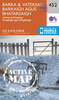
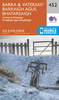
Barra And South Uist / Barraigh Agus Uibhist A Deas

Map No. 31, Barra and South Uist / Barraigh agus Uibhist a Deas, in the Ordnance Survey Landranger series at 1:50, 000, including the islands of Vatersay/ Bhatarsaigh, Eriskay/Eiriosgaigh, Fuday/Fuideigh, Gighay/Gioghaigh, Sandray/Sanndraigh, Pabbay/Pabaigh, Mingulay/Mi
RIP - This product is no longer available on our network. It was last seen on 25.09.2019

This page now acts as a permanent archive for this product. Add more information using the comments box below to ensure it can still be found by future generations.

Use our search facility to see if it is available from an alternative contributor.
  • Availability: Out Of Stock
  • Supplier: Stanfords
  • SKU: 9780319226315
Availability: In Stock
£5.59

Product Description

Map No. 31, Barra & South Uist / Barraigh agus Uibhist a Deas, in the Ordnance Survey Landranger series at 1:50, 000, including the islands of Vatersay/ Bhatarsaigh, Eriskay/ Eiriosgaigh, Fuday/ Fuideigh, Gighay/ Gioghaigh, Sandray/ Sanndraigh, Pabbay/ Pabaigh, Mingulay/ Mi

Reviews/Comments

Add New

Price History

Vouchers

No voucher codes found.
Do you know a voucher code for this product or supplier? Add it to Insights for others to use.

Facebook

Jargon Buster

Supplier Information

Stanfords
Stanfords was established in 1853 and opened their iconic Covent Garden flagship store in 1901. They have become the top retailer of maps, travel books and accessories in the UK and arguably offer the largest selection of maps and travel books worldwide. Famous names such as Captain Robert Falcon Scott, Ranulph Fiennes and Michael Palin have purchased from Stanfords. They now have a shop in Bristol and both stores together with other venues operate a calendar of events including talks, book signings and exhibitions. As a specialist map retailer, the map selection is comprehensive and includes road maps, street maps and walking maps from worldwide destinations, as well as a selection of world atlases and wall maps. Books include travel guides and travel literature. Stanfords also stock globes, from miniatures made of blue marble to magnificent floor-standing globes. The website features a selection of interesting articles on travel topics.
Page Updated: 2023-11-12 20:15:36

Community Generated Product Tags

Oh No! The productWIKI community hasn't generated any tags for this product yet!
Menu