More From Contributor
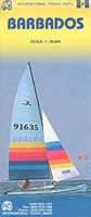
£5.99
Insight Guides Flexi Map: has a weather-proof fold out map of the country with top attractions listed. Ideal for taking on holiday. This Barbados Flexi Map is drawn to a scale of 1:60, 000 & shows the entire country complete with a comprehensive index. This is an ideal on-the-move companion when you`re exploring Barbados It

Includes::
larger scale maps of the west coast, south coast, Bridgetown & Garrison Outlines Top Attractions & places of interest with key facts on the sights
Includes: useful facts for people visiting Barbados Information on how to get around the country


...
Archived Product
£7.99
Barbados offers the ideal Caribbean holiday. Whether you're seeking some serious relaxation in the sun or rugged coastal walking, this island has something to offer everyone. Footprint Focus provides invaluable information on transport, accommodation, eating & entertainment to ensure that your trip

Includes::
the best of this sun-drenched isle. Essentials section with useful advice on getting to & around the island of Barbados. Comprehensive, up-to-date listings of where to eat, sleep & play.

Includes::
information on tour operators & activities, from sipping rum on the plantations to golfing in the sunshine. Detailed maps for Barbados & its key destinations. Slim enough to fit in your pocket. With detailed information on all the main sights, plus many lesser-known attractions, Footprint Focus Barbados provides concise & comprehensive coverage of one the Caribbean's most sought-after destinations.


...
Archived Product
£9.99
The highly successful Globetrotter Travel Series, which

Includes::
Travel Guides, Travel Maps, Road Atlases,

...
Archived Product
£9.99
Barbados in New Holland’s Globetrotter Travel Guide series, comprising a range of practical & accessible guides to a number of cities, regions & countries worldwide. Globetrotter guides incorporate essential information in an easy-to-carry & easy-to-reference format. They provide visitors with an introduction highlighting the country’s ‘must see’ areas, allowing readers to make the most of their time away. Presented in a paperback PVC format, each guide in the series provides vital tips for visitors &

Includes::
information on the best places to stay, eat & shop, star-rated top attractions, detailed regional profiles & recommendations of the best tours & excursions. Individual titles also have a separate, pull-out overview map in the rear pocket of the guide that serves as a companion to the book itself. An introductory section profiles the destination with details of the l&, a brief history, government & economy & the people. Every chapter is summarised in the ‘ At-a-Glance’ sections at the end of each chapter. There is also a Travel Tips section at the back of each guide providing practical guidance & information on tourist information services, entry requirements, customs, health requirements, getting there, what to pack, money matters, accommodation, transport, business hours, time difference, electricity, health precautions, useful phrases, personal safety, emergencies, etiquette & tipping.

...
Archived Product
£7.99
Barbados in the Pocket Guide series from Insight provides detailed commentary on a collection of itinerary based trips in a handy pocket format. Each guide has an historical & cultural introduction, profiling the growth of the region or city. There is also a large selection of localised & pedestrian friendly tour itineraries designed to take in the major sites, as well as a chapter on excursions to other destinations within easy reach. Further sections detail leisure activities including shopping, eating out, nightlife, festivals & local events with accompanying addresses & contact details where relevant. There is also practical guidance on transport, local services, language & accommodation. Each guide also has a large selection of colour photographs & a pull-out pocket map giving an overview of the region. ...
Archived Product
£4.99
Barbados at 1:41, 000 is an indexed map with additional street plans & enlargements of popular regions on the reverse. The publisher has chosen to concentrate on creating a map which will primarily be of use for a tourist navigating between main points of interest as opposed to stressing more detailed cartography. National roads, highways, tarred & untarred minor roads & tracks are clearly marked, as are provincial boundaries. In keeping with the publisher ...
Archived Product
£4.99
Barbados in the Pocket Guide series from Berlitz; a collection of handy, pocket-sized guides dedicated to an extensive range of cities, regions & countries worldwide. Written in narrative form, individual guides explore the history, main sights & attractions, food & drink, accommodation & local culture of the destination in detail. Each Berlitz pocket guide has a similar format, with colour-coded sections helping readers locate information quickly in addition to distinctive chapters exploring the city or region. An introduction outlines the destination for visitors & a section dedicated to 'A Brief History' actually explores the area in relative depth. A where to go chapter is organized by region & city & is written in prose form with references to individual sites highlighted in bold for clarity. There are also further suggestions on where & when to eat. Recommendations for leisure activities in the region, including sport, nightlife & shopping, are also provided & tailored accordingly for each destination. Handy travel tips are listed alphabetically in a dedicated section, providing practical guidance & helping visitors make the most of their stay. The main hotels, particularly for cities, are also listed in an accommodation section, offering a brief overview with approximate price bandings & relevant contact details. ...
Archived Product
£8.99
The highly successful Globetrotter Travel Series, which

Includes::
Travel Guides, Travel Maps, Road Atlases,

...
Archived Product
£9.99
WINNER OF THE PULITZER PRIZE FOR BIOGRAPHY 2016 Surfing only looks like a sport. To devotees, it is something else entirely: a beautiful addiction, a mental & physical study, a passionate way of life. William Finnegan first started surfing as a young boy in California & Hawaii. Barbarian Days is his immersive memoir of a life spent travelling the world chasing waves through the South Pacific, Australia, Asia, Africa, Peru & beyond. Finnegan describes the edgy yet enduring brotherhood forged among the swell of the surf; & recalling his own apprenticeship to the world`s most famous & challenging waves, he considers the intense relationship formed between man, board & water. Barbarian Days is an old-school adventure story, a social history, an extraordinary exploration of one man`s gradual mastering of an exacting & little-understood art. It is a memoir of dangerous obsession & enchantment. ...
Archived Product
£10.99
It`s 1977. Youth unemployment is at an all-time high & the pound is at an all-time low. Paul, Jan & Louis are bored, broke & demoralized by the hand that they`ve been dealt. How will these young lads fair with the odds stacked against them? How will they cope? Cut off from society with no-where to turn, the play resonates with a modern audience who will no doubt recognize the disaffected youth of 1970s Britain. Barrie Keeffe`s tragically dark play crackles with tension throughout, building to a twisted & dramatic end. This programme text edition was published to coincide with the revival of the play by Tooting Arts Club on 3rd October 2015, staged at the former Central St Martins School of Art on the Charing Cross Road, London. ...
Archived Product

Barbados ITMB

Barbados at 1:40, 000 indexed, clear road and tourist map from ITMB with a small enlargement of Bridgetown at 1:8, 000 showing the location of many places of interests. Road network includes motorway and highways with their respective codes, primary and secondary roads and tracks. Symbols clearly indicate petrol stations and the airport. Topography is represented by altitude colouring, contours at 25 metre intervals and spot heights; graphics indicate rivers, marshes, coral reef, etc. The map identifies many places of interest for the tourist such as nature reserves, caves, beaches, watersports and diving spots, marinas, ports, etc. Additional information includes the location of hotels and accommodation facilities, golf courses and embassies, restaurants and shopping areas.
Furthermore, regional boundaries are marked and named. The small insert of central Bridgetown extends just short of the Kensington Oval in the north and the Bayshore complex in the south, the Bridgtown Inter-Island Ferry and Bridgetown Cruiseship terminals in the west and the Weymouth area in the east. It conveniently identifies parking, attractions and shopping areas as well as restaurants, markets and bus terminals.The map is indexed, and latitude and longitude lines are drawn at intervals of 5’.
RIP - This product is no longer available on our network. It was last seen on 25.09.2019

This page now acts as a permanent archive for this product. Add more information using the comments box below to ensure it can still be found by future generations.

Use our search facility to see if it is available from an alternative contributor.
  • External links may include paid for promotion
  • Availability: Out Of Stock
  • Supplier: Stanfords
  • SKU: 9781553411253
Availability: In Stock
£9.99

Product Description

Barbados at 1:40, 000 indexed, clear road & tourist map from ITMB with a small enlargement of Bridgetown at 1:8, 000 showing the location of many places of interests. Road network

Includes::
motorway & highways with their respective codes, primary & secondary roads & tracks. Symbols clearly indicate petrol stations & the airport. Topography is represented by altitude colouring, contours at 25 metre intervals & spot heights; graphics indicate rivers, marshes, coral reef, etc. The map identifies many places of interest for the tourist such as nature reserves, caves, beaches, watersports & diving spots, marinas, ports, etc. Additional information

Includes::
the location of hotels & accommodation facilities, golf courses & embassies, restaurants & shopping areas. Furthermore, regional boundaries are marked & named. The small insert of central Bridgetown extends just short of the Kensington Oval in the north & the Bayshore complex in the south, the Bridgtown Inter-Island Ferry & Bridgetown Cruiseship terminals in the west & the Weymouth area in the east. It conveniently identifies parking, attractions & shopping areas as well as restaurants, markets & bus terminals. The map is indexed, & latitude & longitude lines are drawn at intervals of 5’.

Reviews/Comments

Add New

Price History

Vouchers

No voucher codes found.
Do you know a voucher code for this product or supplier? Add it to Insights for others to use.

Facebook

Jargon Buster

Graphics - A general term for visual aspects of an item/display
Network - A link and communication between things. Often computers or people.
Small - something that takes up less space than normal.
Road - a manmade lane or a path that is used to speed up travel.
Metre - 100cm. A unit of length.
Altitude - Something that can be quite high in relation to sea or ground level.
Golf - A sport played on a large outside grass course, the aim to hit a small ball with a club into small holes.
Accommodation - A room in which someone can live in, for example in a hotel
Regional - An adjective to describe a set geographic area.
Primary - the beginning of something, of chief importance.

Supplier Information

Stanfords
Stanfords was established in 1853 and opened their iconic Covent Garden flagship store in 1901. They have become the top retailer of maps, travel books and accessories in the UK and arguably offer the largest selection of maps and travel books worldwide. Famous names such as Captain Robert Falcon Scott, Ranulph Fiennes and Michael Palin have purchased from Stanfords. They now have a shop in Bristol and both stores together with other venues operate a calendar of events including talks, book signings and exhibitions. As a specialist map retailer, the map selection is comprehensive and includes road maps, street maps and walking maps from worldwide destinations, as well as a selection of world atlases and wall maps. Books include travel guides and travel literature. Stanfords also stock globes, from miniatures made of blue marble to magnificent floor-standing globes. The website features a selection of interesting articles on travel topics.
Page Updated: 2023-11-12 20:15:36

Community Generated Product Tags

Oh No! The productWIKI community hasn't generated any tags for this product yet!
Menu