
 United Kingdom
 France
 Germany
 Netherlands
 Sweden
 USA
USA
 Italy
Italy
 Spain
Spain
More From Contributor


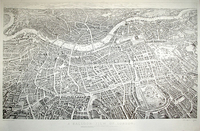
Balloon View Of London
One of several maps and panoramas of London to come out in 1851, the year of the Great Exhibition. This is an aerial panorama, naming streets and showing many individual buildings. The view is looking southwards and therefore appears ”upside-down” compared to most maps. The enormous glass building built in Hyde Park for the Great Exhibition is shown - Cockneys dubbed it the ”Crystal Palace” and it`s even named as such on the panorama.The map is an exhilarating view of London looking south over the River Thames, as if taken from a balloon over Hampstead. This plan/view`s extent (St John`s Wood - Battersea Park - De Beauvoir Town - Greenwich) and large size makes for a superbly detailed image with innumerable streets, buildings and landmarks identifiable. First published on the
opening day of the Great Exhibition, the plan proved immensely popular with reissues appearing into the late 1870s. This is an early Stanford edition with the aquatint detail fresh and distinct, and presents a wonderful picture of London prior to the great Victorian expansion.
opening day of the Great Exhibition, the plan proved immensely popular with reissues appearing into the late 1870s. This is an early Stanford edition with the aquatint detail fresh and distinct, and presents a wonderful picture of London prior to the great Victorian expansion.

Product Description
Reviews/Comments
Add New
Intelligent Comparison
Archived Product
Balloon View Of London, 1851 Stanfords
£7.99
Archived Product
Balloon View Of London, 1851 Stanfords
£7.99
Vouchers
No voucher codes found.
Do you know a voucher code for this product or supplier? Add it to Insights for others to use.
Do you know a voucher code for this product or supplier? Add it to Insights for others to use.
 Denmark