More From Contributor

£5.99
A sticker book with a difference, this delightful book contains 13 scenes & over 400 stickers to dress the ballerinas for different occasions. Scenes include the ballerinas performing in ballets such as Sleeping Beauty & the Nutcracker, as well as backstage, rehearsal & many more. Stickers include gorgeous tutus, headdresses & ballet pumps, as well as bags, shoes & jewellery to make the ballerinas beautiful. ...
Archived Product
£6.99
Pauline, Petrova & Posy Fossil are sisters
- with a difference. All three were adopted as babies by Great Uncle Matthew, an eccentric
...
Archived Product
£12.99
Topographic survey of France at 1:25, 000 in IGN`s excellent TOP25 / Série Bleue series. All the maps are GPS compatible, with a 1km UTM grid plus latitude & longitude lines at 5’ intervals. Contours are at 5m intervals except for mountainous areas where the maps have contours at 10m intervals, vividly enhanced by hill shading & graphics for rocky terrain. Colouring with graphics indicates different types of vegetation or land use (deciduous or coniferous forests, moors, orchards, vineyards, etc). PLEASE NOTE: coverage of France at this scale is currently being revised – the format & the presentation of each title are indicated by the letters at the end of its Sheet Reference number (e.g. 0416ET, 3531ETR, 1923SB, etc.)MAPS WITH FULL TOURIST OVERPRINT & AN ENGLISH MAP LEGEND: all TOP25 maps & the SB editions of Série Bleue have an overprint highlighting waymarked walking trails including long-distance GR routes &, where appropriate, ski routes. Symbols indicate campsites, gîtes d’etape, refuges, equestrian centres & other recreational facilities or sites, tourist information centres, cultural heritage, etc. Towns & locations of particular interest are highlighted.- ET or OT = single-sided TOP25 map covering approx. 29x 21 km / 18x 13 miles.- ETR or OTR = waterproof & tear resistant TOP25 map covering the same area as the corresponding ET or OT number, but double-sided, printed on a smaller size sheet with a good overlap between the sides.- SB = Série Bleue map with full tourist overprint; these maps, first introduced in summer 2014, each cover approx. 29x 24km / 18x 15 miles.SÉRIE BLEUE maps with numbers ending in E (Est) or O (Ouest): most editions now indicate the GR routes, but do not show any other tourist information. Map legend is in French only. Each map covers approx. 14x 20km / 9x 12 miles. ...
Archived Product
£19.95
One of several maps & panoramas of London to come out in 1851, the year of the Great Exhibition. This is an aerial panorama, naming streets & showing many individual buildings. The view is looking southwards & therefore appears ”upside-down” compared to most maps. The enormous glass building built in Hyde Park for the Great Exhibition is shown
- Cockneys dubbed it the ” Crystal Palace” & it`s even named as such on the panorama. The map is an exhilarating view of London looking south over the River Thames, as if taken from a balloon over Hampstead. This plan/view`s extent (St John`s Wood
- Battersea Park
- De Beauvoir Town
- Greenwich) & large size makes for a superbly detailed image with innumerable streets, buildings & landmarks identifiable. First published on the opening day of the Great Exhibition, the plan proved immensely popular with reissues appearing into the late 1870s. This is an early Stanford edition with the aquatint detail fresh & distinct, & presents a wonderful picture of London prior to the great Victorian expansion.


...
Archived Product
£7.99
This is a beautiful colour view of London from the perspective of an aerial balloon, looking southwards from Hampstead. Printed in 1851, it shows the brand new Crystal Palace
- erected to house the Great Exhibition
- as well as the early London railways, Victorian Oxford Street, the Tower & eight of the city's bridges, many of which were recent constructions. This is a stunning & unexpected window on a city that was at the centre of a vast empire & at the height of its pomp.

...
Archived Product
£19.99
5 Balloonomania Belles reveals the astonishing stories of the fabulous female pioneers of balloon flight. More than a century before the first aeroplane women were heading for the heavens in crazy, inspired contraptions that could bring death or glory & all too often, both. Award-winning journalist Sharon Wright reveals their hair-raising adventures in a book that brings the stories of the feisty female ballooning heroines together for the first time. Women were in the vanguard of the Balloonomania craze that took hold in the eighteenth & nineteenth centuries & swept across Europe then the world. Their exploits were a vital element of our first voyages into the sky. When womens options were often severely limited by law & convention they managed to join the exhilarating quest for spectacle, adventure & danger among the clouds. Many of the brightest stars of this extraordinary era of human flight were women. From the perilous ascent in 1784 by feisty French teenager Elisabeth Thible, female aeronauts have never looked back or down. Who were these brave women who took to the air when it was such an incredibly dangerous & scandalous thing to dosharon Wright brings together in one book the show-stopping stories of the very first flying women. ...
Archived Product
£6.50
Ballycastle, map No. 5 in the Discoverer series from the Ordnance Survey of Northern Ireland presenting the country on detailed topographic maps at 1:50, 000 with waymarked hiking trails, Sustrans National Cycle Network & other tourist information. Coverage

Includes::
Ballymoney, Bushmills, Cushendall & Rathlin Islands. Current edition F; publication date April 2011. Maps in the Discoverer series have contours at 10m intervals, with plenty of spot heights & bold altitude colouring above 150m. Graphics indicate different types of woodlands. In coastal areas the maps show high & low water mark, cliffs, mud/shingle or s&, etc. Road network grades minor roads according to their widths,

Includes::
local tracks & shows gradients on steep routes. Railways are shown with stations & the maps include other details expected of topographic mapping at this scale. An overprint highlights waymarked walking trails as well as cycle routes of the Sustrans National Cycle Network. Boundaries of National Trust land are marked, indicating areas with limited opening. Places of interest are prominently highlighted & a range of symbols provide other tourist information including camping or caravan sites & youth hostels, bus stations, parking, picnic areas, viewpoints, gold courses, etc. Each map covers an area of 40 x 30km (25 x 19 miles approximately) & has a 1km Irish Grid, plus latitude & longitude margin ticks at 1` intervals. Map legend is English, French & German. On the reverse each sheet has an indexed monochrome map showing townland boundaries. To see the list of all the titles in this series please click on the series link. Ordnance Survey of Irel&.


...
Archived Product
£6.30
Ballymena on an indexed street plan at 1:10, 000 from the Ordnance Survey of Northern Irel&, plus on the reverse an indexed road map at 1:50, 000 of Ballymena District. OSNI street plans highlight main traffic arteries in each town, indicating motorways, A or B roads, one way or pedestrianized streets & car parks. The plans show Sustrans National Cycle Network with route numbers, tow paths & waymarked walks. Also marked are boundaries of local government districts. Public buildings are highlighted by colour & named. Symbols indicate tourist information offices, bus & or railway stations, public toilets & golf courses. Each plan has Irish national grid lines. On the reverse the plans have an indexed road map of the relevant local government district. ...
Archived Product
£2.95
Ballymena in 1903 in a fascinating series of reproductions of old Ordnance Survey plans in the Alan Godfrey Editions, ideal for anyone interested in the history of their neighbourhood or family. Selected towns in Great Britain & Ireland are covered by maps showing the extent of urban development in the last decades of the 19th & early 20th century. In this title: the map covers much of Ballymena, including the town centre. Coverage stretches from the station eastward to the Braid River, & from the Union Workhouse southward to Harryville Bridge. Note that most of Harryville is off the map. Features include town centre with houses & other buildings all neatly delineated, The Castle, Braid Water Mills, station including narrow gauge line, Market Place, Fair Green, Town Parks area, Recreation Ground, Court House, Adair Arms Hotel, weaving factory, Mc Clurkanstown, St Patrick's church, Kintullagh House, District Model School, People's Park, cottage hospital etc. A list of private inhabitants from a contemporary directory is included. About the Alan Godfrey Editions of the 25 ...
Archived Product
£6.50
Map No. 8, Ballymoney, in the Discoverer series from the Ordnance Survey of Northern Ireland presenting the country on detailed topographic maps at 1:50, 000 with waymarked hiking trails, Sustrans National Cycle Network & other tourist information. Coverage in this title

Includes::
Portglenone, Cullybackey & Garvagh. The maps have contours at 10m intervals, with plenty of spot heights & bold altitude colouring above 150m. Graphics indicate different types of woodlands. In coastal areas the maps show high & low water mark, cliffs, mud/shingle or s&, etc. Road network grades minor roads according to their widths,

Includes::
local tracks & shows gradients on steep routes. Railways are shown with stations & the maps include other details expected of topographic mapping at this scale. An overprint highlights waymarked walking trails as well as cycle routes of the Sustrans National Cycle Network. Boundaries of National Trust land are marked, indicating areas with limited opening. Places of interest are prominently highlighted & a range of symbols provide other tourist information including camping or caravan sites & youth hostels, bus stations, parking, picnic areas, viewpoints, gold courses, etc. Each map covers an area of 40 x 30km (25 x 19 miles approximately) & has a 1km UTM grid, plus latitude & longitude margin ticks at 1' intervals. Map legend is English, French & German. On the reverse each sheet has an indexed monochrome map showing townland boundaries. Please note: numbers not listed here cover the Irish Republic (Eire) & are shown on our website in a separate


...
Archived Product

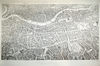
Balloon View Of London, 1851

This is a beautiful colour view of London from the perspective of an aerial balloon, looking southwards from Hampstead. Printed in 1851, it shows the brand new Crystal Palace - erected to house the Great Exhibition - as well as the early London railways, Victorian Oxford Street, the Tower and eight of the city's bridges, many of which were recent constructions. This is a stunning and unexpected window on a city that was at the centre of a vast empire and at the height of its pomp.
RIP - This product is no longer available on our network. It was last seen on 25.09.2019

This page now acts as a permanent archive for this product. Add more information using the comments box below to ensure it can still be found by future generations.

Use our search facility to see if it is available from an alternative contributor.
  • Availability: Out Of Stock
  • Supplier: Stanfords
  • SKU: 9781908402813
Availability: In Stock
£7.99

Product Description

This is a beautiful colour view of London from the perspective of an aerial balloon, looking southwards from Hampstead. Printed in 1851, it shows the brand new Crystal Palace
- erected to house the Great Exhibition
- as well as the early London railways, Victorian Oxford Street, the Tower & eight of the city's bridges, many of which were recent constructions. This is a stunning & unexpected window on a city that was at the centre of a vast empire & at the height of its pomp.

Reviews/Comments

Add New

Intelligent Comparison

Oooops!
We couldn't find anything!
Perhaps this product's unique.... Or perhaps we are still looking for comparisons!
Click to bump this page and we'll hurry up.

Price History

Vouchers

No voucher codes found.
Do you know a voucher code for this product or supplier? Add it to Insights for others to use.

Facebook

Jargon Buster

Balloon - A inflatable bag filled with a type of gas commonly helium, hydrogen or air
Railways - A set of tracks that have been laid for the purpose of trains to travel up and down them
Colour - The categorised spectrum of light visable to humans
Crystal - A solid substance that has symmetrically carved plane faces and can be regularly found in jewellery.
Crystal - A solid clear substance with many surfaces that glisten, commonly used in jewellery
Crystal - A solid substance with symmetrically arranged planes, commonly found in jewellery.

Supplier Information

Stanfords
Stanfords was established in 1853 and opened their iconic Covent Garden flagship store in 1901. They have become the top retailer of maps, travel books and accessories in the UK and arguably offer the largest selection of maps and travel books worldwide. Famous names such as Captain Robert Falcon Scott, Ranulph Fiennes and Michael Palin have purchased from Stanfords. They now have a shop in Bristol and both stores together with other venues operate a calendar of events including talks, book signings and exhibitions. As a specialist map retailer, the map selection is comprehensive and includes road maps, street maps and walking maps from worldwide destinations, as well as a selection of world atlases and wall maps. Books include travel guides and travel literature. Stanfords also stock globes, from miniatures made of blue marble to magnificent floor-standing globes. The website features a selection of interesting articles on travel topics.
Page Updated: 2023-11-12 20:15:36

Community Generated Product Tags

Oh No! The productWIKI community hasn't generated any tags for this product yet!
Menu