
 United Kingdom
 France
 Germany
 Netherlands
 Sweden
 USA
USA
 Italy
Italy
 Spain
Spain
More From Contributor


Bad Urach
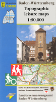
One of the titles in a series of double-sided topographic maps with hiking routes and tourist information. Cartography is identical to the standard topographic survey of Germany, with contours at 10m intervals. Extensive overprint highlights numerous local footpaths and long-distance hiking routes, indicating waymarking. Cycling routes, mountain bike centres and trails, and cross-country ski routes are also marked. Extensive range of symbols highlight sport and leisure facilities, various types of accommodation, places of interest, tourist railways, etc. Boundaries of national parks and nature reserves are marked. The maps have a 2km UTM grid. Map legend includes English. The maps also have lists of contact details of various organizations and facilities within the region, plus
brief descriptions in German only.
brief descriptions in German only.

Product Description
Reviews/Comments
Add New
Intelligent Comparison
Archived Product

Bad Rodach Stanfords
£11.50
Vouchers
No voucher codes found.
Do you know a voucher code for this product or supplier? Add it to Insights for others to use.
Do you know a voucher code for this product or supplier? Add it to Insights for others to use.
 Denmark