
 United Kingdom
 France
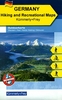
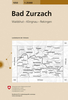
 Germany
 Netherlands
 Sweden
 USA
USA
 Italy
Italy
 Spain
Spain
More From Contributor
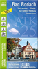

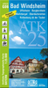

Bad Tölz - Lenggries And The Surrounding Area
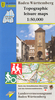
Bad Tölz - Lenggries and the Surrounding Area, map no. 50-52, in a series of special contoured and GP-compatible recreational maps from the Bavarian state survey organization, with cartography of the German topographic survey at 1:50, 000 and extensive additional tourist overprint highlighting waymarked hiking trails and cycling routes, campsites and youth hostels, etc.Maps in this series have cartography identical to the standard topographic survey of Germany. Topography is vividly presented by contours at 20m intervals, enhanced by bold shading and graphic relief, plus colouring and/or graphics to show forests and other types of vegetation.Extensive tourist overprint highlights local and long-distance footpaths and cycle routes - including King Ludwig Way, different variants of
the Way of St James, etc - indicating, where appropriate, their waymarking designation. Symbols show various types of accommodation (campsites, youth hostels, refuges, etc), sport and recreational facilities, places of interest, ski and cable car lift, etc. The maps have UTM grid lines at 1-km UTM intervals. Map legend and, where included, additional text, are in German only.To see the other titles in this series please click on the series link.
the Way of St James, etc - indicating, where appropriate, their waymarking designation. Symbols show various types of accommodation (campsites, youth hostels, refuges, etc), sport and recreational facilities, places of interest, ski and cable car lift, etc. The maps have UTM grid lines at 1-km UTM intervals. Map legend and, where included, additional text, are in German only.To see the other titles in this series please click on the series link.
Product Description
Reviews/Comments
Add New
Vouchers
No voucher codes found.
Do you know a voucher code for this product or supplier? Add it to Insights for others to use.
Do you know a voucher code for this product or supplier? Add it to Insights for others to use.
 Denmark