
 United Kingdom
 France
 Germany
 Netherlands
 Sweden
 USA
USA
 Italy
Italy
 Spain
Spain
More From Contributor


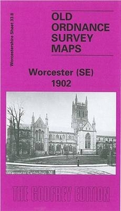
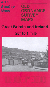
Worcester South-East 1902
Worcester South-East in 1902 in a fascinating series of reproductions of old Ordnance Survey plans in the Alan Godfrey Editions, ideal for anyone interested in the history of their neighbourhood or family. Worcester is covered by four maps; this title shows the south-eastern quarter of of the city, stretching from High Street eastward to Nunnery Farm, and from Tallow Hill southward to Redhill Cross. A major feature of the map is the Cathedral and a good part of the city centre is shown. Other features include Worcester & Birmingham Canal, south part of Shrub Hill station and railway approaches, MR engine shed, Wyld`s Lane Junction, Deanery, Guildhall, Worcester Vinegar Works, Workhouse, Spring Hill area, Green Hill area, Royal Porcelain Works, St Peter`s church, Cottage
Homes, St Catherine`s Hill, Battenhall Mount, Red Hill, Perry Wood, sauce manufactory, etc. On the reverse is selection of street directory entries, including College Green/Precincts/Street/Yard, The Cross, Friar Street, High Street, New Street, Shambles, Sidbury and Wyld`s Lane. About the Alan Godfrey Editions of the 25” OS Series:Selected towns in Great Britain and Ireland are covered by maps showing the extent of urban development in the last decades of the 19th and early 20th century. The plans have been taken from the Ordnance Survey mapping and reprinted at about 15 inches to one mile (1:4, 340). On the reverse most maps have historical notes and many also include extracts from contemporary directories. Most maps cover about one mile (1.6kms) north/south, one and a
half miles (2.4kms) across; adjoining sheets can be combined to provide wider coverage.FOR MORE INFORMATION AND A COMPLETE LIST OF ALL AVAILABLE TITLES PLEASE CLICK ON THE SERIES LINK.

Product Description
Reviews/Comments
Add New
Intelligent Comparison
Archived Product
Worcester North-East 1902 Stanfords
£3.50
Archived Product

Worcester South-West 1902 Stanfords
£3.50
Archived Product

Worcester North-West 1902 Stanfords
£3.50
Archived Product
Leicester South East 1902 Stanfords
£3.50
Archived Product
Gloucester South East 1901 Stanfords
£3.50
Archived Product

Bristol South-East 1902 Stanfords
£3.50
Archived Product
Manchester South-East 1915 Stanfords
£3.50
Archived Product
Doncaster South 1901 Stanfords
£3.50
Vouchers
No voucher codes found.
Do you know a voucher code for this product or supplier? Add it to Insights for others to use.
Do you know a voucher code for this product or supplier? Add it to Insights for others to use.
 Denmark