
 United Kingdom
 France
 Germany
 Netherlands
 Sweden
 USA
USA
 Italy
Italy
 Spain
Spain
More From Contributor


Worcester North-East 1902
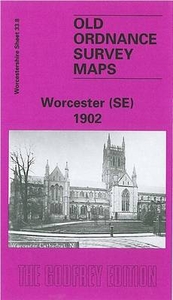
Worcester North-East in 1902 in a fascinating series of reproductions of old Ordnance Survey plans in the Alan Godfrey Editions, ideal for anyone interested in the history of their neighbourhood or family. Worcester is covered by four maps. This title covers the north-eastern quarter of the city, stretching from Foregate Street eastward to Elbury Hill, and from Lowesmoor northward to Astwood Cemetery. A major feature of the map is the railway coverage which includes Foregate Street station, the northern part of Shrub Hill station, engine sheds, loco and wagon repairing works, sidings, the Tunnel Loop Line, Tunnel Junction, Rainbow Hill Junction, Sheet Sheds etc. Other features include Shrub Hill Engineering Works, Shire Hall, Lansdowne Terrace, St Mary Magdalene church, gas
works, Vulcan Iron Works, Newtown, Merriman`s Hill, Gregory`s Mill (disused), Worcester & Birmingham Canal, Rainbow Hill area, Portefields Farm, Ronkswood House, Brickfields Farm, etc. On the reverse is a selection of street directory entries, including Arboretum Road, Astwood Road, Chesnut Walk, Foregate Street, Lowesmoor, Middle Street, Rainbow Hill, Sansome Place/Street/Walk, Shrub Hill Road and Tunnel Hill. About the Alan Godfrey Editions of the 25” OS Series:Selected towns in Great Britain and Ireland are covered by maps showing the extent of urban development in the last decades of the 19th and early 20th century. The plans have been taken from the Ordnance Survey mapping and reprinted at about 15 inches to one mile (1:4, 340). On the reverse most maps have
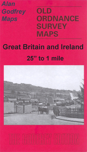
historical notes and many also include extracts from contemporary directories. Most maps cover about one mile (1.6kms) north/south, one and a half miles (2.4kms) across; adjoining sheets can be combined to provide wider coverage.FOR MORE INFORMATION AND A COMPLETE LIST OF ALL AVAILABLE TITLES PLEASE CLICK ON THE SERIES LINK.
works, Vulcan Iron Works, Newtown, Merriman`s Hill, Gregory`s Mill (disused), Worcester & Birmingham Canal, Rainbow Hill area, Portefields Farm, Ronkswood House, Brickfields Farm, etc. On the reverse is a selection of street directory entries, including Arboretum Road, Astwood Road, Chesnut Walk, Foregate Street, Lowesmoor, Middle Street, Rainbow Hill, Sansome Place/Street/Walk, Shrub Hill Road and Tunnel Hill. About the Alan Godfrey Editions of the 25” OS Series:Selected towns in Great Britain and Ireland are covered by maps showing the extent of urban development in the last decades of the 19th and early 20th century. The plans have been taken from the Ordnance Survey mapping and reprinted at about 15 inches to one mile (1:4, 340). On the reverse most maps have
historical notes and many also include extracts from contemporary directories. Most maps cover about one mile (1.6kms) north/south, one and a half miles (2.4kms) across; adjoining sheets can be combined to provide wider coverage.FOR MORE INFORMATION AND A COMPLETE LIST OF ALL AVAILABLE TITLES PLEASE CLICK ON THE SERIES LINK.
Product Description
Reviews/Comments
Add New
Intelligent Comparison
Archived Product

Worcester North-West 1902 Stanfords
£3.50
Archived Product
Worcester South-East 1902 Stanfords
£3.50
Archived Product

Worcester South-West 1902 Stanfords
£3.50
Archived Product

Bristol North-East 1902 Stanfords
£3.50
Archived Product
Leicester North East 1913 Stanfords
£3.50
Archived Product

Leicester North West 1902 Stanfords
£3.50
Archived Product
Leicester South East 1902 Stanfords
£3.50
Archived Product

Gloucester North West 1901 Stanfords
£3.50
Vouchers
No voucher codes found.
Do you know a voucher code for this product or supplier? Add it to Insights for others to use.
Do you know a voucher code for this product or supplier? Add it to Insights for others to use.
 Denmark