
 United Kingdom
 France
 Germany
 Netherlands
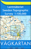
 Sweden
 USA
USA
 Italy
Italy
 Spain
Spain
More From Contributor


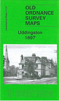
Uddingston 1897
Uddingston in 1897 in a fascinating series of reproductions of old Ordnance Survey plans in the Alan Godfrey Editions, ideal for anyone interested in the history of their neighbourhood or family. Features include Caledonian Railway with station, NBR railway with station, Bothwell & Uddingston Gas Works, Douglas Gardens, town centre, Bothwell Castle Home Farm, Gardenside area, Porters Well area, River Clyde, etc. Coverage extends south to Bothwell Castle, remains of Blantyre Priory, Kirklands Lunatic Asylum, and westward to Blantyreferme House. On the reverse is an 1892-3 directory of Uddingston.About the Alan Godfrey Editions of the 25” OS Series:Selected towns in Great Britain and Ireland are covered by maps showing the extent of urban development in the last decades of the
19th and early 20th century. The plans have been taken from the Ordnance Survey mapping and reprinted at about 15 inches to one mile (1:4, 340). On the reverse most maps have historical notes and many also include extracts from contemporary directories. Most maps cover about one mile (1.6kms) north/south, one and a half miles (2.4kms) across; adjoining sheets can be combined to provide wider coverage.FOR MORE INFORMATION AND A COMPLETE LIST OF ALL AVAILABLE TITLES PLEASE CLICK ON THE SERIES LINK.
19th and early 20th century. The plans have been taken from the Ordnance Survey mapping and reprinted at about 15 inches to one mile (1:4, 340). On the reverse most maps have historical notes and many also include extracts from contemporary directories. Most maps cover about one mile (1.6kms) north/south, one and a half miles (2.4kms) across; adjoining sheets can be combined to provide wider coverage.FOR MORE INFORMATION AND A COMPLETE LIST OF ALL AVAILABLE TITLES PLEASE CLICK ON THE SERIES LINK.

Product Description
Reviews/Comments
Add New
Intelligent Comparison
Archived Product

Paddington 1872 Stanfords
£3.50
Archived Product

Haddington 1893 Stanfords
£2.95
Archived Product

Paddington 1893 Stanfords
£3.50
Archived Product

Haddington 1893 Stanfords
£3.50
Archived Product
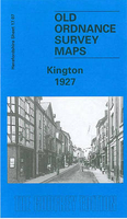
Kington 1927 Stanfords
£3.50
Archived Product

Paddington 1914 Stanfords
£3.50
Vouchers
No voucher codes found.
Do you know a voucher code for this product or supplier? Add it to Insights for others to use.
Do you know a voucher code for this product or supplier? Add it to Insights for others to use.
 Denmark