More From Contributor
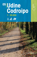
£16.99
Topographic survey of Sweden at 1:50, 000, the Terrängkartan, from the Lantmäteriet, covering most of the country in 244 double-sided maps. Please note: the mountainous regions of central & northern Sweden are not covered by this series but presented in a separate “ Fjällkartan
- Mountain Map” series also listed on our website. Each 1:50, 000 topographic survey map covers an area of 37.5 x 40km. The maps have contours at 5 metre intervals, plus relief shading & graphics for rocky outcrops & boulders. Further graphics and/or colouring show different types of land use or vegetation (forests, arable l&, orchards, marshes, peat bogs, etc). An unusual feature of this survey is the colouring indicating buildings below or above two storeys high & “leisure/holiday homes”. The maps indicate privately maintained roads & include all other information expected of topographic survey at this scale. The maps have a 1-km UTM grid, plus latitude & longitude lines 5’ intervals. Map legend

Includes::
English. For coverage of the country’s most visited hiking areas in central & northern Sweden please see Lantmäteriet’s Mountain Map series, listed separately on our website.


...
Archived Product
£3.50
Uddingston in 1897 in a fascinating series of reproductions of old Ordnance Survey plans in the Alan Godfrey Editions, ideal for anyone interested in the history of their neighbourhood or family. Features include Caledonian Railway with station, NBR railway with station, Bothwell & Uddingston Gas Works, Douglas Gardens, town centre, Bothwell Castle Home Farm, Gardenside area, Porters Well area, River Clyde, etc. Coverage extends south to Bothwell Castle, remains of Blantyre Priory, Kirklands Lunatic Asylum, & westward to Blantyreferme House. On the reverse is an 1892-3 directory of Uddingston. About the Alan Godfrey Editions of the 25” OS Series: Selected towns in Great Britain & Ireland are covered by maps showing the extent of urban development in the last decades of the 19th & early 20th century. The plans have been taken from the Ordnance Survey mapping & reprinted at about 15 inches to one mile (1:4, 340). On the reverse most maps have historical notes & many also include extracts from contemporary directories. Most maps cover about one mile (1.6kms) north/south, one & a half miles (2.4kms) across; adjoining sheets can be combined to provide wider coverage.FOR MORE INFORMATION & A COMPLETE LIST OF ALL AVAILABLE TITLES PLEASE CLICK ON THE SERIES LINK. ...
Archived Product
£9.99
Udine at 1: 10, 000 on an indexed street plan from Litografia Artistica Cartografica in their Globalmap imprint. 42 monuments including historic buildings & churches, cultural or educational institutions, & important municipal buildings or facilities are numbered & listed next to the plan. Car parks in & around the city’s historic centre are prominently marked. Litografia Artistica Cartografica (LAC) are Italy’s leading publishers of street plans with an extensive range of titles. Where appropriate, the plans include an enlargement showing the historic centre in greater detail. On each plan monuments including historic buildings & churches, archaeological sites, cultural or educational institutions, & important municipal buildings or facilities are numbered & listed next to the plan. Unless indicated to the contrary in the individual description, one way streets are not marked. Street index is on the reverse. ...
Archived Product
£11.50
This series of Odos cycling maps are at a scale of 1:35, 000 & have prominently marked out cycling routes that are differentiated into different types of cycle situation & terrain. Ideal for planning suitable routes & knowing which routes to avoid whether you are on a mountain bike or road bike. These maps are also suitable for walking & horseback riding. Routes marked include: cycle path, cycle route with low motor traffic, cycle route with moderate motor traffic, cycle route on unpaved country road, motorway, district road, secondary paved road, unsurfaced road & footpath. Campsites & other useful details are also marked. With elevation markings, UTM coordinate references, longitude & latitude lines at 3’ intervals. Accompanied by a colour booklet with around 40 pages with places of interest & suggested routes with symbols to indicate difficulty, distances there & back. Please note that the booklet is in Italian but map legend

Includes::
an English translation.

...
Archived Product
£12.99
Udine Province at 1:150, 000 in a series of handy size provincial road maps from Litografia Artistica Cartografica (LAC) with more minor local roads & country tracks than can be found on most regional maps from other publishers. This title is now available in a digitally produced edition.LAC’s provincial series is gradually being changed to a new style of digitally derived cartography, so presentation of adjoining titles may vary. All the maps have hill shading to represent the general relief with spot heights for selected peaks, & show a few more local roads & rough tracks than the other road map series. Intermediate road distances are indicated. Regional, provincial & communal borders are marked, & railways, funiculars, airports, sea ferry links & campsites are shown. The legend is in Italian only. The new, digitally produced editions are indexed & have enhanced, more finely drawn cartography: the hill-shading is less bold, motorway service areas are marked, natural parks are highlighted & an expanded range of symbols indicates various landmarks & sites, e.g. antiquities, churches, etc. Two styles of the new cartography are produced, differing only in the colour of the predominant background shading: grey or yellow/green. Some of the new editions include geographical coordinates for the map corners. The index of localities is on the reverse. To see all the titles in this series please click on the series link. ...
Archived Product
£190.00
Udrone, an original antique map by J. Hondius, published in Amsterdam, 1607 -1608. A copperplate engraving, original colour. Map size 13 x 17 cm, with a mount size of 33.5 x 39.5 cm.A seventeenth-century map of Udrone with original colour. The title appears in a decorative cartouche at lower right & the map was published in Hondius' Atlas Minor. Jodocus Hondius I (1563-1612) was one of the foremost map engravers of his day. Having settled in the relatively stable Amsterdam, Hondius bought the copperplates of Mercator's Atlas Sive Cosmographicae.. . at the auction of Gerard Jr.'s effects in 1604. He added another forty maps, including new maps of the continents & important regional maps of the Americas, before publishing a new edition of the Atlas.. . in 1606. Jodocus also had the plates of the Atlas.. . reduced at this time in order to publish them in the Atlas Minor that first appeared in 1607. Cornelis Clasz & Johannes Janssonius of Arnhem (the elder Janssonius) were the publishers involved in this `miniature' endeavour. Antique maps from various original publishers are presented on the Stanford ...
Archived Product
£8.50
Map No. 859, Ueckermünde
- Pasewalk
- Prenzlau, in a series of hiking maps from Kompass providing extensive coverage of Austria

...
Archived Product

Udine - Codroipo

This series of Odos cycling maps are at a scale of 1:35, 000 and have prominently marked out cycling routes that are differentiated into different types of cycle situation and terrain. Ideal for planning suitable routes and knowing which routes to avoid whether you are on a mountain bike or road bike. These maps are also suitable for walking and horseback riding.Routes marked include: cycle path, cycle route with low motor traffic, cycle route with moderate motor traffic, cycle route on unpaved country road, motorway, district road, secondary paved road, unsurfaced road and footpath. Campsites and other useful details are also marked.With elevation markings, UTM coordinate references, longitude and latitude lines at 3’ intervals.Accompanied by a colour booklet with around 40
pages with places of interest and suggested routes with symbols to indicate difficulty, distances there and back. Please note that the booklet is in Italian but map legend includes an English translation.
RIP - This product is no longer available on our network. It was last seen on 25.09.2019

This page now acts as a permanent archive for this product. Add more information using the comments box below to ensure it can still be found by future generations.

Use our search facility to see if it is available from an alternative contributor.
  • External links may include paid for promotion
  • Availability: Out Of Stock
  • Supplier: Stanfords
  • SKU: 9788896303177
Availability: In Stock
£11.50

Product Description

This series of Odos cycling maps are at a scale of 1:35, 000 & have prominently marked out cycling routes that are differentiated into different types of cycle situation & terrain. Ideal for planning suitable routes & knowing which routes to avoid whether you are on a mountain bike or road bike. These maps are also suitable for walking & horseback riding. Routes marked include: cycle path, cycle route with low motor traffic, cycle route with moderate motor traffic, cycle route on unpaved country road, motorway, district road, secondary paved road, unsurfaced road & footpath. Campsites & other useful details are also marked. With elevation markings, UTM coordinate references, longitude & latitude lines at 3’ intervals. Accompanied by a colour booklet with around 40 pages with places of interest & suggested routes with symbols to indicate difficulty, distances there & back. Please note that the booklet is in Italian but map legend

Includes::
an English translation.

Reviews/Comments

Add New

Intelligent Comparison

Oooops!
We couldn't find anything!
Perhaps this product's unique.... Or perhaps we are still looking for comparisons!
Click to bump this page and we'll hurry up.

Price History

Vouchers

No voucher codes found.
Do you know a voucher code for this product or supplier? Add it to Insights for others to use.

Facebook

Jargon Buster

Motor - A evice that converts electricity into motion
Italian - A word used ot descibe something from Italy
Colour - The categorised spectrum of light visable to humans
Road - a manmade lane or a path that is used to speed up travel.
Ideal - Something that satisfies a perfect criteria.

Supplier Information

Stanfords
Stanfords was established in 1853 and opened their iconic Covent Garden flagship store in 1901. They have become the top retailer of maps, travel books and accessories in the UK and arguably offer the largest selection of maps and travel books worldwide. Famous names such as Captain Robert Falcon Scott, Ranulph Fiennes and Michael Palin have purchased from Stanfords. They now have a shop in Bristol and both stores together with other venues operate a calendar of events including talks, book signings and exhibitions. As a specialist map retailer, the map selection is comprehensive and includes road maps, street maps and walking maps from worldwide destinations, as well as a selection of world atlases and wall maps. Books include travel guides and travel literature. Stanfords also stock globes, from miniatures made of blue marble to magnificent floor-standing globes. The website features a selection of interesting articles on travel topics.
Page Updated: 2023-11-12 20:15:36

Community Generated Product Tags

Oh No! The productWIKI community hasn't generated any tags for this product yet!
Menu