
 United Kingdom
 France
 Germany
 Netherlands
 Sweden
 USA
USA
 Italy
Italy
 Spain
Spain
More From Contributor

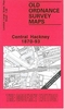


Haddington 1893
Haddington in 1893 in a fascinating series of reproductions of old Ordnance Survey plans in the Alan Godfrey Editions, ideal for anyone interested in the history of their neighbourhood or family. Selected towns in Great Britain and Ireland are covered by maps showing the extent of urban development in the last decades of the 19th and early 20th century.In this title: the map covers most of the town, stretching southward to Lennoxlove Acredales and Clerkington, and westward to St Laurence House Bridge. Features include Trinity church, Haddington Maltings, Rosehall, River Tyne, Nungate Bridge, Market Street area, High Street area, Gimmers Mills, Nungate, Eastgate End, Court Street, Town Hall, Distillery Park, St Mary's church, Acredales, Dobson's Well, Clerkington Mill,
St Laurence House, NBR railway with terminus, Somnerfield Works, etc. On the reverse is a register of voters for 1892.About the Alan Godfrey Editions of the 25
St Laurence House, NBR railway with terminus, Somnerfield Works, etc. On the reverse is a register of voters for 1892.About the Alan Godfrey Editions of the 25

Product Description
Reviews/Comments
Add New
Vouchers
No voucher codes found.
Do you know a voucher code for this product or supplier? Add it to Insights for others to use.
Do you know a voucher code for this product or supplier? Add it to Insights for others to use.
 Denmark