
 United Kingdom
 France
 Germany
 Netherlands
 Sweden
 USA
USA
 Italy
Italy
 Spain
Spain
More From Contributor


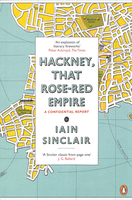
Hackney, That Rose-Red Empire
Hackney, That Rose-Red Empire is Iain Sinclair’s personal record of the area of London in which he has lived for forty years. Fusing fact and fiction, Sinclair seeks to document the traditional spirit of Hackney and to capture the essence of the place, as he has known it, before it succumbs to perfidious green papers, eco exaggerations, sponsored public art and the Olympic Park snapping at its heels. Varyingly described as a comprehensive and intricate historical map of a book, a maze of symbols to interpret, a twisted love letter to the borough and a memoir of dizzying associations, Hackney: That Rose-Red Empire is a message in the bottle of a book, flung into the flood of the future.

Product Description
Reviews/Comments
Add New
Vouchers
No voucher codes found.
Do you know a voucher code for this product or supplier? Add it to Insights for others to use.
Do you know a voucher code for this product or supplier? Add it to Insights for others to use.
 Denmark