
 United Kingdom
 France
 Germany
 Netherlands
 Sweden
 USA
USA
 Italy
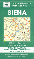
Italy
 Spain
Spain
More From Contributor

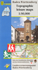


Stuttgart And The Surrounding Area
Map No. 775, Stuttgart and the Surrounding Area, in a series of hiking maps from Kompass providing extensive coverage of Austria and Germany plus the Slovenian Alps, with hiking routes on a topographic base, various types of accommodation, recreational facilities, places of interest, etc. Many titles are now published as competitively priced sets of two or more maps, offering a wider coverage. Kompass are Europe
Product Description
Reviews/Comments
Add New
Intelligent Comparison
Archived Product
Siena And The Surrounding Area Stanfords
£10.99
Archived Product
Moena And The Surrounding Area Stanfords
£6.95
Archived Product
Dortmund And The Surrounding Area Stanfords
£8.95
Archived Product
Merano And The Surrounding Area Stanfords
£8.95
Archived Product
Trento And The Surrounding Area Stanfords
£7.95
Archived Product
Merano And The Surrounding Area Stanfords
£10.95
Archived Product
Kempten And The Surrounding Area Stanfords
£8.25
Archived Product
Kempten And The Surrounding Area Stanfords
£11.50
Vouchers
No voucher codes found.
Do you know a voucher code for this product or supplier? Add it to Insights for others to use.
Do you know a voucher code for this product or supplier? Add it to Insights for others to use.
 Denmark