
 United Kingdom
 France
 Germany
 Netherlands
 Sweden
 USA
USA
 Italy
Italy
 Spain
Spain
More From Contributor

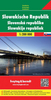


Slovakia Road Atlas
A4 sized, spiral-bound, indexed road atlas of Slovakia at 1:100, 000, with street plans of 35 city centres. Road detail includes minor roads, toll roads and footpaths, with intermediate driving distances marked. Rest areas, petrol stations, bridge heights, gradients, passes, road closures and border crossings are shown. Other transport details include railways, funiculars, cable railways, chair-lifts, airports, airfields and car ferries. Internal administrative boundaries with border crossings and military areas.National parks, other natural reserves, and military reservations are also marked, as are hiking trails, scenic viewpoints and routes and administrative boundaries. A comprehensive range of symbols indicates all religious buildings, various kinds of
accommodation including campsites, antiquities and ruins, leisure facilities and many more geographical and cultural landmarks and places of interest. Latitude and longitude lines are drawn at 5' intervals. The multilingual legend includes English, although notes on GPS use are in Slovakian only. Some useful tourist information for drivers, a distance table, a table of filling station facilities, an index or border crossing points and an extensive index are included. The collection of city centre street plans are at 1:10, 000. These show one-way streets, public buildings, pedestrian areas, railways, information offices and other useful facilities, but are not indexed.
accommodation including campsites, antiquities and ruins, leisure facilities and many more geographical and cultural landmarks and places of interest. Latitude and longitude lines are drawn at 5' intervals. The multilingual legend includes English, although notes on GPS use are in Slovakian only. Some useful tourist information for drivers, a distance table, a table of filling station facilities, an index or border crossing points and an extensive index are included. The collection of city centre street plans are at 1:10, 000. These show one-way streets, public buildings, pedestrian areas, railways, information offices and other useful facilities, but are not indexed.
Product Description
Reviews/Comments
Add New
Intelligent Comparison
Archived Product
Romania Road Atlas Stanfords
£17.95
Archived Product

Bulgaria Road Atlas Stanfords
£9.99
Archived Product
Slovakia Tourist Atlas Stanfords
£24.95
Archived Product
Estonia Road Atlas Stanfords
£23.95
Archived Product
Karelia Road Atlas Stanfords
£13.95
Archived Product
India Road Atlas Stanfords
£17.50
Archived Product
India Road Atlas Stanfords
£4.95
Archived Product
India Road Atlas Stanfords
£17.50
Vouchers
No voucher codes found.
Do you know a voucher code for this product or supplier? Add it to Insights for others to use.
Do you know a voucher code for this product or supplier? Add it to Insights for others to use.
 Denmark