
 United Kingdom
 France
 Germany
 Netherlands
 Sweden
 USA
USA
 Italy
Italy
 Spain
Spain
More From Contributor


India Road Atlas
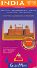
India Road Atlas from TTK providing for state-by-state overview of the road network accompanied by a list of places to visit, plus street plans, regional maps, general maps of India showing main tourist and wildlife sites, etc.The atlas has one page per state, but with the North-Eastern states covered together on one map and Sikkim shown with West Bengal. Scales vary according to the size of each state. The maps show principal road connections and a selection of local roads, plus mail railway lines. Each map page is accompanied by a page with facts and figures about the state, a list of places to visit, and a list of local festivals. Street plans, one page each for Ahmadabad, Bengaluru (Bangalore), Chandigarth, Chennai, Delhi, Hyderabad with Secunderabad, Kolkata, Mumbai,
Mysuru, Thiruvananthapuram and Tirumala, have varying degree of detail but show main streets, railway lines with stations, places of interest, important services and facilities, etc. Also provided are regional maps, e.g. Kolkata to Darjeeling or Mumbai to Goa, to cover larger, cross-state areas. The atlas has an index of principal locations (headquarters) in each state, a plate showing main road signs, a distance table, plus additional maps of the whole of India with main tourist sights, wildlife locations, national highways, principal railway connections, and air routes. Illustrated with several colour photos, the atlas is printed on good quality, glossy paper.
Mysuru, Thiruvananthapuram and Tirumala, have varying degree of detail but show main streets, railway lines with stations, places of interest, important services and facilities, etc. Also provided are regional maps, e.g. Kolkata to Darjeeling or Mumbai to Goa, to cover larger, cross-state areas. The atlas has an index of principal locations (headquarters) in each state, a plate showing main road signs, a distance table, plus additional maps of the whole of India with main tourist sights, wildlife locations, national highways, principal railway connections, and air routes. Illustrated with several colour photos, the atlas is printed on good quality, glossy paper.
Product Description
Reviews/Comments
Add New
Intelligent Comparison
Archived Product
India Road Atlas Stanfords
£17.50
Archived Product
Romania Road Atlas Stanfords
£17.95
Archived Product
Italy Road Atlas Stanfords
£12.99
Archived Product

India Road Map Stanfords
£9.99
Archived Product
Africa Road Atlas Stanfords
£24.95
Archived Product
Poland Road Atlas Stanfords
£33.95
Archived Product
Ireland Road Atlas A4 Stanfords
£7.99
Archived Product
Thailand Road Atlas Stanfords
£7.99
Vouchers
No voucher codes found.
Do you know a voucher code for this product or supplier? Add it to Insights for others to use.
Do you know a voucher code for this product or supplier? Add it to Insights for others to use.
 Denmark