
 United Kingdom
 France
 Germany
 Netherlands
 Sweden
 USA
USA
 Italy
Italy
 Spain
Spain
More From Contributor


Saudi Arabia
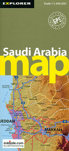
Saudi Arabia at 1:3, 000, 000 from the Dubai based Explorer Publishing, with in the reverse the central part of the country shown at 1:1, 600, 000. Road network shows locations of petrol stations and a distance table is provided. Coverage extends to north-west to Amman, includes Kuwait, Qatar and the United Arab Emirates, although outside Saudi Arabia’s borders only main roads are shown.The map uses satellite image as its base, overprinted with the road network graded into main highways, major and secondary roads and tracks. Driving distances are marked on highways, main and selected secondary roads, with locations of petrol stations and border crossings. Railway lines are included and domestic airports are marked. Symbols highlight various places of interest. The map has
latitude and longitude crosshairs at 2° intervals. On the reverse the country’s central region is shown at 1:1, 600, 000, although without much extra detail in the road network, etc. One combined index for both sides lists selected locations, places of interest, archaeological sites, etc. All place names are shown in Latin alphabet, with map legend and other text in English. Also provided is a distance table.
latitude and longitude crosshairs at 2° intervals. On the reverse the country’s central region is shown at 1:1, 600, 000, although without much extra detail in the road network, etc. One combined index for both sides lists selected locations, places of interest, archaeological sites, etc. All place names are shown in Latin alphabet, with map legend and other text in English. Also provided is a distance table.

Product Description
Reviews/Comments
Add New
Intelligent Comparison
Archived Product
Saudi Arabia Stanfords
£9.95
Archived Product

Saudi Arabia F&B Stanfords
£10.99
Archived Product

Flag Of Saudi Arabia Stanfords
£8.99
Archived Product

Saudi Arabia Gizi Map Stanfords
£9.99
Archived Product
Saudi Arabia Wall Map Stanfords
£13.50
Archived Product
Saudi Arabia: North 24 Stanfords
£14.95
Vouchers
No voucher codes found.
Do you know a voucher code for this product or supplier? Add it to Insights for others to use.
Do you know a voucher code for this product or supplier? Add it to Insights for others to use.
 Denmark