
 United Kingdom
 France
 Germany
 Netherlands
 Sweden
 USA
USA
 Italy
Italy
 Spain
Spain
More From Contributor


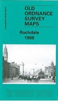
Rochdale 1908
Rochdale in 1908 in a fascinating series of reproductions of old Ordnance Survey plans in the Alan Godfrey Editions, ideal for anyone interested in the history of their neighbourhood or family. The map covers the town centre and an area to the east. Coverage stretches from Lord Street and St Mary`s Gate eastward to Firgrove Bridge, and from Grasmere Street southward to Bilberry Street. Features St Mary`s church, New Market Hall, Butts Mill, Rochdale Bridge, tramways, Town Hall, Broadfield Park, railways (but station is just off to the south), Wardleworth station and part of Facit Branch, Town Head, Public Baths, Croft Mill, Clover Mill, Roach Carriage Works, Belfield Print Works, athletic grounds, Canal Wharf, Belfield, Newbold Brow, Newbold, Waith Lane, St Ann`s
church, Firgrove Mill, Lowfield Mill with stretch of Rochdale Canal, etc. On the reverse are street directory entries for Drake Street, East Street, Molesworth Street and Toad Lane.About the Alan Godfrey Editions of the 25” OS Series:Selected towns in Great Britain and Ireland are covered by maps showing the extent of urban development in the last decades of the 19th and early 20th century. The plans have been taken from the Ordnance Survey mapping and reprinted at about 15 inches to one mile (1:4, 340). On the reverse most maps have historical notes and many also include extracts from contemporary directories. Most maps cover about one mile (1.6kms) north/south, one and a half miles (2.4kms) across; adjoining sheets can be combined to provide wider coverage.FOR MORE INFORMATION
AND A COMPLETE LIST OF ALL AVAILABLE TITLES PLEASE CLICK ON THE SERIES LINK.

Product Description
Reviews/Comments
Add New
Intelligent Comparison
Archived Product
Rochdale West 1908 Stanfords
£2.95
Archived Product
Rochdale West 1908 Stanfords
£3.50
Archived Product
Rochdale South 1908 Stanfords
£3.50
Vouchers
No voucher codes found.
Do you know a voucher code for this product or supplier? Add it to Insights for others to use.
Do you know a voucher code for this product or supplier? Add it to Insights for others to use.
 Denmark