
 United Kingdom
 France
 Germany
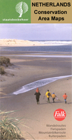
 Netherlands
 Sweden
 USA
USA
 Italy
Italy
 Spain
Spain
More From Contributor


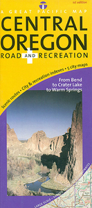
Oregon Central
Central Oregon on a detailed, GPS compatible, double-sided map from the Great Pacific Recreation & Travel Maps at 1:203, 000 approx, with a very extensive index of recreational facilities, geographic features, parks and campgrounds, etc.The map covers an area of central Oregon extending on its northern side from roughly north of Madras to south of Bend and from the Cascades range in the west to the Ochoco Mountains in the east. The map continues on the reverse extending the coverage to Cabin Lake - Fort Rock Wildlife area and including the Newberry National Volcanic Monument and the Deschutes National Forest with numerous lakes. A separate inset at 1:345, 000 approx. extends the map further to the south to include the Carter Lake National Park.Topography is shown by relief shading
with altitude colouring. Numerous peaks are marked and boundaries of various protected areas are shown. Road network indicates unpaved roads, 4WD tracks and other backroads, with scenic routes prominently highlighted. The map also shows the course of the Pacific Crest Trail and local trails. Symbols indicate locations of campgrounds, picnic areas, winter recreational areas, etc. Latitude and longitude lines are drawn at 10’ intervals/ A very extensive index lists communities and Indian reservations, natural features and wonders, parks, campgrounds and recreational areas, fishing lakes and reservoirs, trails and trailheads, viewpoints, etc.The map also includes five panels with more detailed street maps of local towns: Bend, Redmond and Prineville (all with enlargement for
downtown areas), plus Sisters and Sunriver. All have indexes for places of interest, parks, recreational facilities, etc.

Product Description
Reviews/Comments
Add New
Intelligent Comparison
Archived Product
Drenthe Central Stanfords
£8.99
Archived Product

Siena Central Stanfords
£6.50
Archived Product
Sligo Central Stanfords
£8.25
Archived Product

Florence Central Stanfords
£6.50
Archived Product
Sarhro Central Stanfords
£10.00
Archived Product
Preston Central 1909 Stanfords
£3.50
Vouchers
No voucher codes found.
Do you know a voucher code for this product or supplier? Add it to Insights for others to use.
Do you know a voucher code for this product or supplier? Add it to Insights for others to use.
 Denmark