
 United Kingdom
 France
 Germany
 Netherlands
 Sweden
 USA
USA
 Italy
Italy
 Spain
Spain
More From Contributor

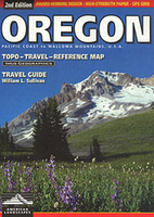
Oregon
Oregon at 1:750, 000 on a detailed, indexed map published by Imus Geographics, highlighting Oregon’s numerous state forests and other protected areas, with lists of scenic roads and waterways, descriptions of various regions, etc.Topography is shown by light relief shading, with plenty of names of various topographic features: mountain ranges, peaks with heights, etc. More rivers or lakes are shown and named than on other maps of the state. Boundaries of national parks, state forest and other protected areas are highlighted. Also marked are Indian reservations and internal administrative boundaries.With the wealth of topographic information in the background, road network is inevitably less clearly visible than on purely road maps, but is presented distinguishing between paved
highways (shown with driving distances), improved dirt or gravel highways and 4WD tracks. Railways lines are included and local airports are marked. Also shown is the course of the historic Oregon Trail. Symbols indicate state parks with camping facilities or for day use only, ranger stations and visitor centres, wildlife watching sites, ski areas, etc. Latitude and longitude lines are drawn at 30’ and 1° intervals respectivelyThe map includes a distance table, lists of Oregon’s scenic roads and waterways, plus on the reverse descriptions of the state region by region.
highways (shown with driving distances), improved dirt or gravel highways and 4WD tracks. Railways lines are included and local airports are marked. Also shown is the course of the historic Oregon Trail. Symbols indicate state parks with camping facilities or for day use only, ranger stations and visitor centres, wildlife watching sites, ski areas, etc. Latitude and longitude lines are drawn at 30’ and 1° intervals respectivelyThe map includes a distance table, lists of Oregon’s scenic roads and waterways, plus on the reverse descriptions of the state region by region.

Product Description
Reviews/Comments
Add New
Vouchers
No voucher codes found.
Do you know a voucher code for this product or supplier? Add it to Insights for others to use.
Do you know a voucher code for this product or supplier? Add it to Insights for others to use.
 Denmark