
 United Kingdom
 France
 Germany
 Netherlands
 Sweden
 USA
USA
 Italy
Italy
 Spain
Spain
More From Contributor


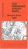
Newark East 1899
Newark East in 1899 in a fascinating series of reproductions of old Ordnance Survey plans in the Alan Godfrey Editions, ideal for anyone interested in the history of their neighbourhood or family. Selected towns in Great Britain and Ireland are covered by maps showing the extent of urban development in the last decades of the 19th and early 20th century.In this title: the map covers the eastern part of Newark, stretching from Wellington Road eastward to Hillside and beyond. Features include GNR railway with Newark Junction but not station, gas works, Hatton House, engine shed, Beaconhill Road area, Cemetery (at foot of map), malthouse with railway connection, Hillside, Beacon Hill, Highfield, Great Northern Brick Works etc. On the reverse are street directory entries for Barnby
Gate, Barnby Road, Beacon Hill, Beacon Hill Road, Charles Street, Cross Street, Harcourt Street, Private Street, Vernon Street and Wellington Street. About the Alan Godfrey Editions of the 25
Gate, Barnby Road, Beacon Hill, Beacon Hill Road, Charles Street, Cross Street, Harcourt Street, Private Street, Vernon Street and Wellington Street. About the Alan Godfrey Editions of the 25
Product Description
Reviews/Comments
Add New
Intelligent Comparison
Archived Product

Newark East 1899 Stanfords
£3.50
Archived Product

Newquay East 1933 Stanfords
£3.50
Archived Product

Crook East 1896 Stanfords
£3.50
Vouchers
No voucher codes found.
Do you know a voucher code for this product or supplier? Add it to Insights for others to use.
Do you know a voucher code for this product or supplier? Add it to Insights for others to use.
 Denmark