More From Contributor
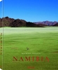
£5.99
The Globetrotter Travel Map of Namibia caters specifically for the needs of tourists who are new to a destination. The town plans of the major centres pinpoint key buildings & places of interest as well as where to stay. Distance & climate charts enable travellers to plan their visits in advance. ...
Archived Product
£65.00
Michael Poliza captures some of the country`s most spectacular scenery, from the highest star dunes in the world around Sossusvlei to the Namib Rand Nature Reserve, the Kalahari Desert, & the granite peaks of the Spitzkoppe. Taken from both the ground & the air, more than 100 photographs present the country`s nature & wildlife, as well as its indigenous peoples & their ways of life as cattle breeders & smallholder farmers. ...
Archived Product
£10.99
Namibia at 1:1, 500, 000 on a double-sided, waterproof & tear-resistant map from Nelles Verlag, with coverage of western Botswana including the Okavango Delta & Chobe NP, plus the Victoria Falls. Several insets provide street plans & enlargements of popular tourist areas. Namibia is divided north/south, with a generous small overlap; Windhoek, Swakopmund & Walvis Bay are included on both sides. Coverage along the Zambezi Region (formerly the Caprivi Strip) extends eastwards to include Livingstone & the Victoria Falls, plus northern Botswana with the Okavango Delta & Chobe National Park; the southern half also covers most of the Kgalagadi Transfrontier Park with the Mabuasehube Reserve. Relief shading with spot heights & names of mountain ranges & peaks very effectively presents the topography. Road network distinguishes between asphalt, gravel or dirt roads & 4WD only tracks, & shows distances on many routes. Restricted access areas are clearly marked. Railway lines & local airports are included, & the map also shows internal administrative boundaries with names of the provinces. National parks or protected areas & numerous other places of interest are prominently highlighted. Latitude & longitude lines are drawn at intervals of 30’. The map has no index. Map legend

Includes::
English. Numerous insets, highlighting places of interest & selected tourist accommodation, cover: central Windhoek, Walvis Bay, Swakopmund, Keetmanshoop, Lüderitz, Tsumeb, Okahandja, & Maun. Enlargements show in greater detail Fish River Canyon, Sossusvlei, environs of Lüderitz, Waterberg, plus the Victoria Falls including the town on the Zimbabwe side of the border.

...
Archived Product
£6.95
Namibia in the Culture Smart range of pocket-sized guide books; providing detailed information on local customs, culture, etiquette & manners & ensuring that visitors are prepared for a diverse range of social environments. The series covers an extensive number of countries worldwide & are designed both for those working & living abroad, as well as for visitors who do not want to offend, either intentionally or inadvertently. Their aim is to prevent readers from making embarrassing mistakes & feel confident in unfamiliar situations, while preparing them before arrival on what to expect & how to behave. Each guide is arranged thematically, with dedicated individual chapters on land & people, values & attitudes, customs & traditions, making friends, people at home, ‘time-out’, travelling & communicating. There is also a separate chapter for business travelers, with important information on subjects such as business culture, meetings & making appointments. A Further Reading section also offers a list of recommended other history, travel literature & language titles available on the country. ...
Archived Product
£13.99
Namibia on a large, waterproof & tear-resistant map at 1:1, 000, 000 from the Swiss Hallwag/Kümmerly + Frey cartographic house, highlighting the county’s 77 best sights, each with a brief description, plus street plans of central Windhoek, Walvis Bay, Lüderitz & Swakopmund. The map is double-sided with a generous overlap & Windhoek included on both sides. The Zambezi Province (previously the Caprivi Strip) is shown on an inset, with coverage there extending to the Victoria Falls. Topography is indicated by shading & altitude colouring, with numerous spot heights & names of mountain ranges, deserts, etc. Graphics show swamps & salt pans; national parks & other protected areas are highlighted. Road classification indicates main roads with bad surface, minor roads & selected cross-country tracks. Restricted entry sections & locations of fuel stations are marked & border crossings indicate opening times. Railway lines are shown with stations & local airports are marked. Namibia’s 77 best sights are cross-referenced to the surrounding panels of brief descriptions, many illustrated with photos. The map also highlights numerous accommodation options, graded as: hotel or B&B, guest or hunting farm, lodge or tented lodge, & campsite indicating those operated by the Namibia Wildlife resort of Namibia Community Based Tourism organizations. The map has no geographical coordinates. The index lists a selection of locations. Also included are street plans of central Windhoek, Walvis Bay, Lüderitz & Swakopmund annotated with main sights & recommendations for hotels, restaurants, shopping, etc. Map legend & all the text include English. ...
Archived Product
£9.99
National Geographic Adventure Maps are the most authoritative maps for touring international destinations. Each waterproof & tear-resistant map provides travellers with the perfect combination of detail & perspective, highlighting points of interest for those venturing outside city centres. Visit Namibia with this National Geographic Adventure Map. Scale: 1:1, 200, 000 Flat Size: 959 x 648 mm. ...
Archived Product
£16.99
Namibia in the Travel Guide series from Bradt; encompassing a comprehensive range of titles to destinations worldwide, with a particular focus on Africa, Central & South America. Bradt are one of the country’s leading independent publishers & have an ethos that focuses on responsible travel, in alliance with a philosophy of sustainability; both in the destinations the guides cover but also in encouraging tourists to limit the impact they have on the local environment. Bradt guides have a reputation for appealing to more independent travelers & often cover destinations that are not available from other publishers. Each guide opens with two comprehensive chapters on Background & Practical Information, covering details of the country’s geography, culture, natural history, government & politics, economy, people, language, religion, education & culture. Important practical advice

Includes::
when to visit, highlights, suggested itineraries, tour operators, red tape, embassies & consulates, getting there & away, health, safety, what to take, money, budgeting, getting around, accommodation, eating & drinking, public holidays, shopping, arts & entertainment, media & communications, business, travel culture & cultural etiquette. Individual sections are organized geographically by region & typically open with information on practicalities & orientation, before focusing on what to see & where to go. Information on what to see, where to stay, where to eat & how to find your way around is provided, with a range of budgets catered for. Simple black & white maps locate key visitor sites & places of accommodation. Bradt Travel Guides include appendices that provide an in-depth introduction to the language of each country, a glossary of terms & a listing of books & internet resources providing further information on the destination.

...
Archived Product
£10.99
Namibia at 1:1, 000, 000 from Freytag & Berndt with a separate booklet attached to the map cover also providing a street plan of central Windhoek. The map is double-sided with a very generous overlap between the sides. Caprivi Strip is shown as a separate inset at 1:1, 200, 000 Topography is shown by relief shading with spot heights plus graphics and/or colouring indicating sandy or rocky deserts, salt lakes or flats, wells & hot springs, etc. Many seasonal rivers & lakes are included. National parks & other protected areas are prominently highlighted. Road network

Includes::
country tracks, with road numbers very clearly presented & distances shown on many smaller routes. Locations of petrol stations & border crossings are marked. Railway lines are included & local airports are marked. Also shown are internal administrative boundaries with names of the provinces. Symbols highlight various places of interest including UNESCO World Heritage sites. The map has latitude & longitude lines at 1° intervals. Most place names are in larger print than found on other maps. Multilingual map legend

Includes::
English. The index is in a separate booklet attached to the map cover &

Includes::
a street plan of central Windhoek. Also provided is a showing time zones within Africa & Europe.


...
Archived Product
£9.99
Namibia at 1:1, 400, 000 on light, waterproof at tear-resistant map published by Freytag & Berndt in their “ World Compact” series which combines a country map with street plans & extensive tourist information: descriptions of places of interest, a fact-box, etc. The map is double-sided, with an overlap between the sides; the Caprivi Strip is shown as an inset. Topography is shown by very effective relief shading with spot heights, graphics for salt lakes, swamps, deserts, oasis, water wells, etc, & plenty of names of geographical features. National parks & other protected areas are highlighted. Road network

Includes::
main & selected local tracks, gives distances on most routes & shows locations of filling stations. Railway lines are included & local airports are marked. Also shown are internal administrative boundaries with names of the provinces. Icons indicate various places of tourist interest such as campsites, archaeological sites, hot springs, beaches & snorkeling sites, etc. The map is indexed & has latitude & longitude lines drawn at 1° intervals.A special feature of Freytag & Berndt’s World Compact series are additional street plans & information panels, illustrated with colour photos, with descriptions of main tourist destinations, important natural features, facts & figures about the country, a phrase book, tourist tips, etc. The map of Namibia

Includes::
a street plan of central Windhoek. Map legend & all the text in the information panels is bilingual English – German.


...
Archived Product
£9.99
Namibia in New Holland’s Globetrotter Travel Guide series, comprising a range of practical & accessible guides to a number of cities, regions & countries worldwide. Globetrotter guides incorporate essential information in an easy-to-carry & easy-to-reference format. They provide visitors with an introduction highlighting the country’s ‘must see’ areas, allowing readers to make the most of their time away. Presented in a paperback PVC format, each guide in the series provides vital tips for visitors &

Includes::
information on the best places to stay, eat & shop, star-rated top attractions, detailed regional profiles & recommendations of the best tours & excursions. Individual titles also have a separate, pull-out overview map in the rear pocket of the guide that serves as a companion to the book itself. An introductory section profiles the destination with details of the l&, a brief history, government & economy & the people. Every chapter is summarised in the ‘ At-a-Glance’ sections at the end of each chapter. There is also a Travel Tips section at the back of each guide providing practical guidance & information on tourist information services, entry requirements, customs, health requirements, getting there, what to pack, money matters, accommodation, transport, business hours, time difference, electricity, health precautions, useful phrases, personal safety, emergencies, etiquette & tipping.

...
Archived Product

Namibia 4

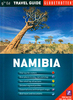
The highly successful Globetrotter Travel Series, which includes Travel Guides, Maps and Road Atlases, presently covers more than 80 destinations worldwide. The Packs are excellent value, including both a guidebook and a softcover version of the fold-out Globetrotter map of the region, in a printed plastic wallet. The handy pocket-size guide is packed with useful information, tips and recommendations, accompanied by colour photographs, charts and maps for the first-time traveller who wants to experience the major highlights that Namibia has to offer.This travel book surpasses other guides in that it incorporates essential information in an easy-to-carry and easy-to-read format that is attractive and useful at the same time. It provides a visitor with an invaluable introduction to
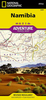
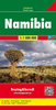
Namibia by concisely highlighting the region's 'must see' areas in a practical and user-friendly format, thus encouraging the tourist to make the most of his/her available time. All the essential information you need to get around an unfamiliar region is compacted into useful and practical 'At-a-Glance' sections at the end of each chapter. The fold-out map of Namibia is ideal for tourists and visitors.In addition to the main map of Namibia, which highlights scenic routes, it features 3 detailed area maps and 5 town plans.
RIP - This product is no longer available on our network. It was last seen on 25.09.2019

This page now acts as a permanent archive for this product. Add more information using the comments box below to ensure it can still be found by future generations.

Use our search facility to see if it is available from an alternative contributor.
  • Availability: Out Of Stock
  • Supplier: Stanfords
  • SKU: 9781847730428
Availability: In Stock
£8.99

Product Description

The highly successful Globetrotter Travel Series, which

Includes::
Travel Guides, Maps & Road Atlases, presently covers more than 80 destinations worldwide. The Packs are excellent value, including both a guidebook & a softcover version of the fold-out Globetrotter map of the region, in a printed plastic wallet. The handy pocket-size guide is packed with useful information, tips & recommendations, accompanied by colour photographs, charts & maps for the first-time traveller who wants to experience the major highlights that Namibia has to offer. This travel book surpasses other guides in that it incorporates essential information in an easy-to-carry & easy-to-read format that is attractive & useful at the same time. It provides a visitor with an invaluable introduction to Namibia by concisely highlighting the region's 'must see' areas in a practical & user-friendly format, thus encouraging the tourist to make the most of his/her available time. All the essential information you need to get around an unfamiliar region is compacted into useful & practical ' At-a-Glance' sections at the end of each chapter. The fold-out map of Namibia is ideal for tourists & visitors. In addition to the main map of Namibia, which highlights scenic routes, it features 3 detailed area maps & 5 town plans.

Reviews/Comments

Add New

Intelligent Comparison

Oooops!
We couldn't find anything!
Perhaps this product's unique.... Or perhaps we are still looking for comparisons!
Click to bump this page and we'll hurry up.

Price History

Vouchers

No voucher codes found.
Do you know a voucher code for this product or supplier? Add it to Insights for others to use.

Facebook

Jargon Buster

Plastic - A generic term for a synthetic product used in the manufacture of products
Colour - The categorised spectrum of light visable to humans
Size - is the measurement of how big an object is in space.
Road - a manmade lane or a path that is used to speed up travel.
Practical - Weather a task is easy to carry out and realistically succeed.
Experience - To gain further knowledge by practising.
Pocket - A bag shaped insert in clothing used to carry items
Invaluable - Something that cannot be replaces as it is indispensable.
Ideal - Something that satisfies a perfect criteria.

Supplier Information

Stanfords
Stanfords was established in 1853 and opened their iconic Covent Garden flagship store in 1901. They have become the top retailer of maps, travel books and accessories in the UK and arguably offer the largest selection of maps and travel books worldwide. Famous names such as Captain Robert Falcon Scott, Ranulph Fiennes and Michael Palin have purchased from Stanfords. They now have a shop in Bristol and both stores together with other venues operate a calendar of events including talks, book signings and exhibitions. As a specialist map retailer, the map selection is comprehensive and includes road maps, street maps and walking maps from worldwide destinations, as well as a selection of world atlases and wall maps. Books include travel guides and travel literature. Stanfords also stock globes, from miniatures made of blue marble to magnificent floor-standing globes. The website features a selection of interesting articles on travel topics.
Page Updated: 2023-11-12 20:15:36

Community Generated Product Tags

Oh No! The productWIKI community hasn't generated any tags for this product yet!
Menu