
 United Kingdom
 France
 Germany
 Netherlands
 Sweden
 USA
USA
 Italy
Italy
 Spain
Spain
More From Contributor


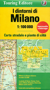
Milan And Environs
Milan and its environs on a light, waterproof and tear-resistant, double-sided map with excellent clear cartography, plus street plans of town centres of Milan, Como, Bergamo, Monza, Lecco, Varese, Stresa and Vimercate. On one side is a map at 1:52, 500 of the city’s immediate environs, showing detail down to many isolated individual farmhouses. Road junctions are very clearly drawn and, where appropriate, named. The map is accompanied by a street plan of central Milan and a diagram of the city’s metro network.On the reverse a map at 1:100, 000 covering the area mainly north of Milan, including the southern part of the lakes Como, Maggiore and Lecco. Relief shading shows the topography and regional parks are clearly marked. The map is accompanied by street plans of local
towns: Bergamo with a separate enlargement of the Old Town, plus Como, Monza, Lecco, Varese, Stresa and Vimercate. Unusually for street plans, where appropriate, e.g. for Bergamo’s Old Town, the plans have contour lines.Neither of the two road maps has geographical coordinates or an index. Map legend includes English.
towns: Bergamo with a separate enlargement of the Old Town, plus Como, Monza, Lecco, Varese, Stresa and Vimercate. Unusually for street plans, where appropriate, e.g. for Bergamo’s Old Town, the plans have contour lines.Neither of the two road maps has geographical coordinates or an index. Map legend includes English.

Product Description
Reviews/Comments
Add New
Intelligent Comparison
Archived Product
Bolzano And Environs Stanfords
£8.50
Archived Product
Vlora And Environs Stanfords
£11.99
Archived Product
Ulm And Environs Stanfords
£10.95
Archived Product

Ljubljana And Environs Stanfords
£11.99
Archived Product

Ljubljana And Environs Stanfords
£14.99
Archived Product

Puka And Environs Stanfords
£11.99
Archived Product
Livigno And Environs Stanfords
£12.99
Archived Product

Saranda And Environs Stanfords
£10.99
Vouchers
No voucher codes found.
Do you know a voucher code for this product or supplier? Add it to Insights for others to use.
Do you know a voucher code for this product or supplier? Add it to Insights for others to use.
 Denmark